
1 August 2016 Padang Melang, Anambas
We left “Amulet” in the anchorage and went off to explore the (“pirate”) islands to the north of Jermaja. On the way, we popped into a couple of anchorages on the northern tip of Jemaja that we thought might be suitable for an overnight stay.
The first small bay (Jemaja North 2) at 03°02.87N 105°43.96E was okay, but we would have to anchor in 15-18 metres between fringing reefs. The second bay (Jemaja North 1) at 03°02.10N 105°43.30E was better protected, but again the anchorage is in 17 metres between reefs. Neither of these anchorages seemed special to us.

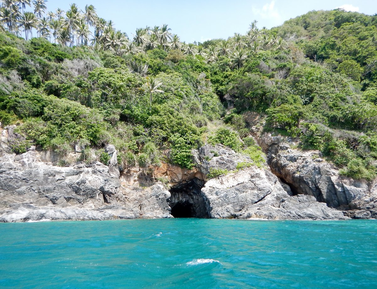
A few days ago, I’d been told by a Reef Survey Team that there was an underwater cave at the east point of Pulau Impul, so we headed a few miles north to that island, where there’s a bay containing a small island (Pulau Impul Kecil) and a large village ashore. After exploring the bay, we found two possible anchorages - one in 20 metres of water in the middle of the bay and the other on a shallower sandy patch to the east of Pulau Impul Kecil. Both are very exposed to the south winds that we have at the moment.
I was keen to find the underwater cave, so we anchored on the sandy patch at 03°04.83N 105°43.73E in 7 metres on sand. It’s great holding and, even with 20 knot south winds, it’s a good day anchorage.
We hopped into the dinghy and found the Cave at 03°05.10N 105°44.10E. Feeling all excited, we donned our snorkelling gear and swam into the cave. It was a huge disappointment. The cave was only 40 metres long and fizzled out with no underwater passages - just a load of garbage floating on the water. While we were there, we spent 15 minutes snorkelling around the rocky reef outside the cave which was average.
On our way back to the boat, we snorkelled next to a big rock awash on the rocky reef to the south of Pulau Impul Kecil, which was interesting - there’s some huge plate coral structures and plenty of large fish. Glenys spotted a Blacktip Reef Shark and I found some interesting Pelagic Trunicates, which are like transparent sponges. These creatures join together and form ribbon like colonies, which swims around as water is siphoned through the middle of their bodies. Being translucent they are very hard to photograph.

By this time, it was around noon. We were hoping to head west to an anchorage at Pulau Anak, but the clouds were building and the south wind was picking up, so we decided to give up on our exploration and head back to the rock-solid anchorage at Padang Melang.
On the way, we stopped for lunch at an anchorage next to a beach in Kembung Bay at 03°02.32N 105°44.10E in 12 metres of water on sand. It was very close to the reef, but you could anchor further out in 18 metres. It’s a very pretty place to anchor, but is exposed for south-east and south winds.
Back at Padang Melang, we chilled out for the rest of the afternoon and invited Rick and Marianne from “Going Easy Too” over for a beer in the evening.
2 August 2016 Padang Melang to Tukan Bay, Anambas
The wind blew hard last night and we woke to a pleasant day, but strong 20-25 knot winds from the south. We were planning to head towards Letung, on the west coast of Jemaja, but we would be pounding into the south wind and the anchorages are exposed, so we decided to wait until the winds drops.
Over the past three years, when we’re in remote places, we’ve been relying on getting GRIB files via our satellite phone, but I’ve let the call-plan on our satellite phone expire for this year and have been relying on 3G internet access. The only place in the Anambas with internet access is Tarempa, so we’ve not had a weather forecast for the last 5 days, which is very frustrating. Fortunately, “Going Easy To” has a recent forecast stretching to Friday, which indicates that the winds will drop later in the week.
For a change of scenery, we upped anchor and had a lovely sail a few miles east to Tukan Bay, where we anchored in 7 metres of water at 02°58.49N 105°46.94E. It’s a nice looking bay with a white sand beach fringed by coconut palms.

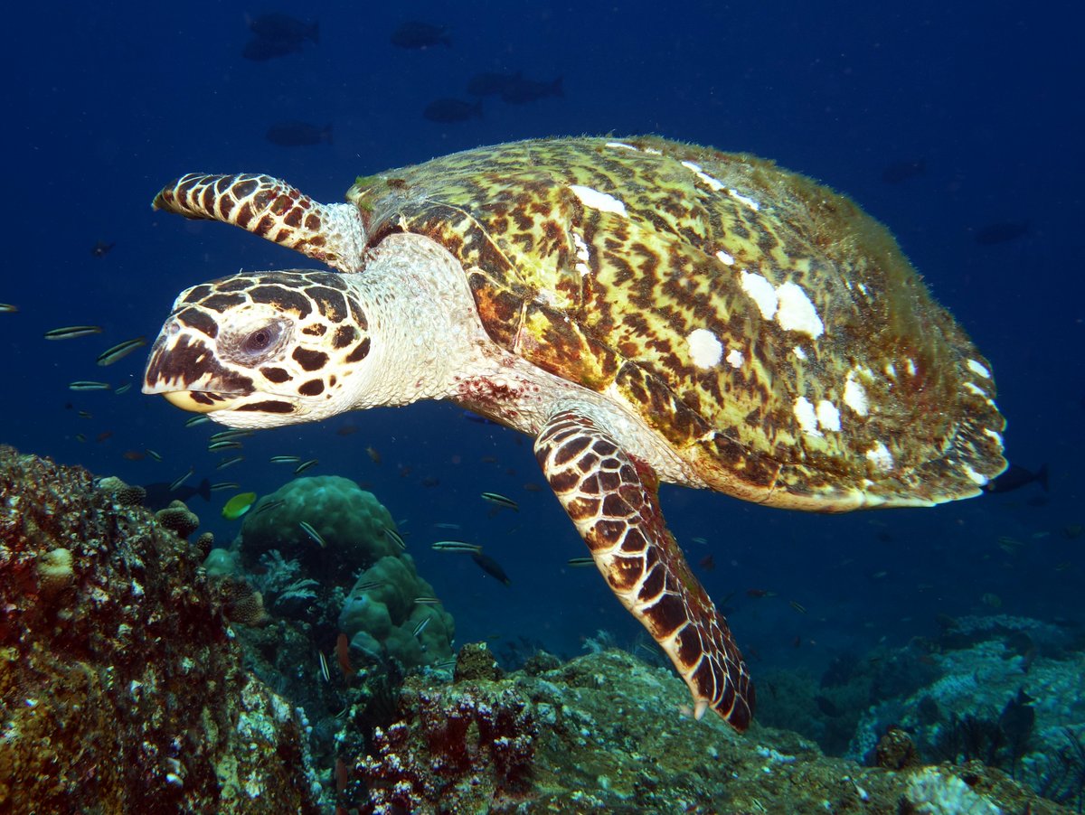
In the afternoon, we went snorkelling at a couple of spots, which were above average. We especially liked the reef on the west side of the bay, which was very healthy. Glenys come across a turtle which swam around here once before disappearing off - she thinks it was a Hawksbill Turtle.
In the evening, we went over to “Easy Going Too” for a few beers - they only had a couple of weeks here and are heading back to Nongsa tomorrow.
3 August 2016 Tukan Bay to Letung, Anambas
We woke to a lovely morning, a little overcast, but the wind was below 15 knots, so we planned to head west to check out Pulau Anak and then, in the afternoon, continue down to Letung on the west coast of Jemaja.
It took us a couple of hours to reach the north-west tip of Jemaja, by which time ominous black clouds had built in the south-west sky, so we abandoned going to Pulau Anak and decided to head straight for Letung. We rounded the corner with only five miles to go, but ten minutes later, a squall line hit us with 40 knot south-west winds and lashing rain. There was nothing that we could do apart from motor straight into the wind and building waves.
“Amulet” was an hour ahead of us and they headed for Djutan Bay, anchoring at 03°00.64N 105°41.27E in 22 metres of water. We had twenty minutes of bashing into 40 knot winds and lashing rain, but by the time that we arrived next to “Amulet”, the wind had abated to less than 25 knots and the rain had reduced considerably, so we decided to carry on to Letung, just a couple of miles around the corner.
It was tough getting through the gap between the mainland and a small island called Pulau Ipan because we had a south setting current with a strong 25 knot wind from the south. The wind against tide plus the wind waves that had built up in the storm left some spectacular standing waves in the passage. We took a few corkers with the bow being buried deep beneath the waves, but managed to power our way through the 15 metre deep channel without any real dramas.

We anchored off the small island next to the town of Letung at 03°00.64N 105°41.28E in 20 metres of water. It seems to be good holding sand - I hope so, this weather still looks unsettled and we might get another 40 knot squall go through like this morning.
The island next to the anchorage is attractive and there looks to be a rocky outcrop on the rather steep hill, which might be a photo opportunity, but the anchorage was so bouncy with waves coming from all directions, that we couldn’t be bothered to get off our backsides. We just lurked on the boat and sulked all afternoon.
Just before we were going to open a cold beer, a local coastal cargo ship left the nearby ferry dock and anchored too close to us. He was about 100 foot long and anchored on a length of rope, so I was worried that they were going to swing differently to us with our chain. After staring at them for fifteen minutes, we cracked up and moved. As always seems to happen when we re-anchor, we got it wrong the first time and ended up too close to “Amulet”, but on the second attempt, we were miles away from both of them. Hopefully, I’ll get some sleep tonight.
Whenever, we go to a beach in the Anambas, there's always a huge pile of plastic garbage. To our dismay, a guy on the cargo boat dumped a huge bag of garbage overboard which then floated past us. They just don't understand that it takes thousands of years to break down the plastic.
4 August 2016 Letung to Padang Melang, Anambas
It was an unsettled night, a little windy at times, but mostly very bouncy and rolly - I had to get up at 02:00 to stop some torches rolling about in a drawer - clunk, clunk…..clunk. The alarm went off at 06:00 and, with a deep sigh, we crawled out of bed to go to the local market.

The dinghy route into the town is 1.2 miles long and rather convoluted having to avoid numerous shallow reefs with the sun in our sleep-bleary eyes…
We parked the dinghy at a dock next to a restaurant at 02°59.25N 105°42.28E. There was a large coastal cargo boat tied up, but more than enough room for our dinghy. The dock has horizontal wooden planks, thankfully without any sharp nails, and we were easily able to scramble up to dry land.
The market street was much busier than when we visited last week and we were able to buy a frozen chicken, some squid and various vegetables that will keep us going for a couple of weeks until we get back to Tarempa.
We were back at the boat by 07:30 and, after a quick bowl of cereal, we were soon on our way. I’m sure that this would be a good anchorage in settled weather, but it’s unpleasant in this south-west swell.
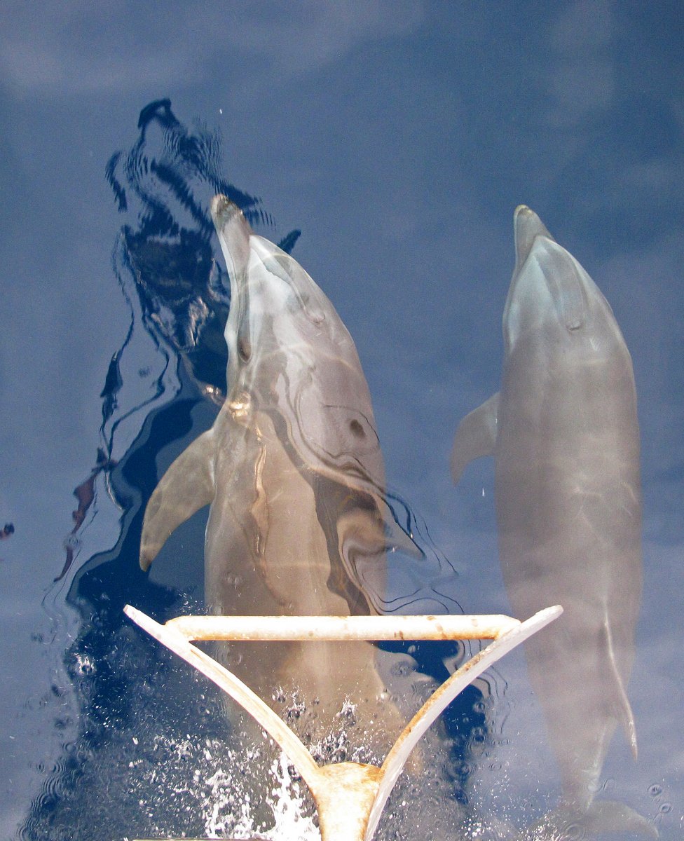
As we went past Pulau Ipan, we had two Bottle-nosed Dolphins join us for ten minutes - they looked like a mother and youngster and were enjoying the standing waves as we crashed through the passage. On the way north, we had a look at three more possible anchorages, but didn’t stop because they were affected by swell. (See my Cruising Notes for more information).
It was a great relief to drop our anchor in 5 metres of water in the lovely Padang Melang anchorage. We spent the afternoon chilling out and catching up on some sleep.
5 August 2016 Padang Melang, Anambas
It was a fabulously calm night and we woke refreshed. Glenys was feeling dynamic, so she did a load of washing and then baked some bread. Meanwhile I caught up on my blog and editing photographs, while I ran the water maker.

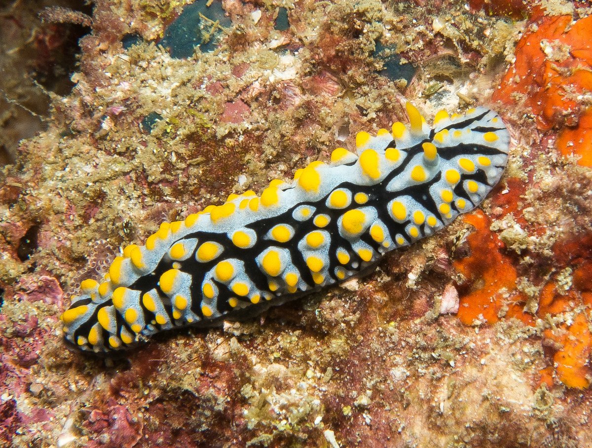
Later in the morning, we zipped off to some isolated rocks which are 1¼ miles to the north-east of the anchorage. It was above average snorkelling, with fairly clear water and interesting rocky terrain, especially on the deeper eastern side of the largest rocks. Not many big fish, but I found a Sky Blue Phyllidia nudibranch and Glenys came across a large lobster carcass - so there are some lobsters around - we’ll be keeping our eyes peeled from now on …
We chilled out for the afternoon and then had “Amulet” over for a beer.
6 August 2016 Padang Melang, Anambas
The weather looked nice and settled this morning, so we decided that we’d have a third attempt to go out to Pulau Anak, with the intention of staying the night. However, the God of Weather had a different idea and by the time that we’d got to the north-west corner of Jemaja, there were thick black clouds gathering on the horizon.
Remembering the hammering that we had three days ago, we spun around 180 degrees and headed back to Padang Melang. Within 15 minutes, the wind was up to 20 knots and, 35 minutes later, we were getting gusts of 35 knots as we rounded Pulau Mingga and into the shelter of Telok Mampo Bay. Thirty minutes later, we were anchoring back where we started in torrential rain - at least I had a nice cooling shower.
The speed that this weather changes is incredible. “Amulet” have managed to download a 7 day GRIB weather forecast, but it doesn’t show these localised squalls that just seem to bubble up. However, there is a kind of pattern with the systems approaching from the south-west and the strong winds coming from the south to south-west. Also, at least the heavy weather only lasts for a couple of hours.

This is the third time this week that we’ve attempted to get out to Pulau Anak, so it’s obvious that some Deity doesn’t want us to go there. We’ve decided to give up and we’re going to start heading east tomorrow, back towards Tarempa. We chilled out for the afternoon, hiding from the persistent rain.
Later, while Glenys was making dinner, she discovered that her precious Basmati Rice is now loaded with Weevils. The worrying thing is how long have we been eating “extra protein”?
7 August 2016 Padang Melang to Pulau Telaga, Anambas
It was a lovely day, so we headed 10 miles east to Pulau Telaga and had a lovely sail. We anchored at 03°05.55N 105°58.01E in 18 metres on sand. Even though the wind was blowing at 15-20 knots from the south, the anchorage was settled and it’s a pretty place.
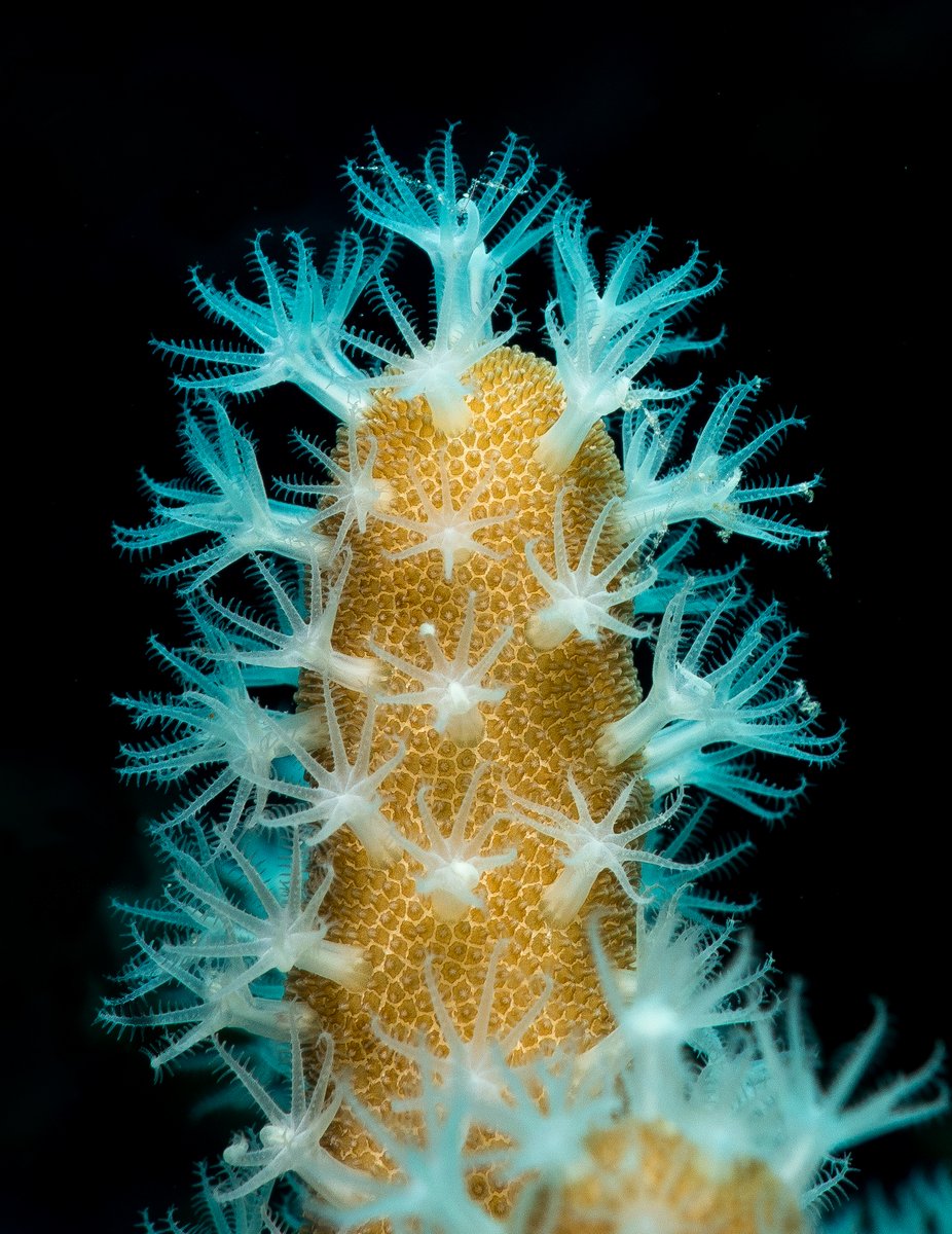
After lunch, I filled our dive tanks and we went for a scuba dive. The wind was quite strong, so we took the dinghy across the channel and anchored in the shelter of a small headland at 03°05.71N 105°57.80E. We descended to 22 metres and turned south following the bottom of the reef. There was a lot of sediment and small jellyfish in the water, but the hard and soft corals were in very good condition.
When our tanks were down to 100 bar we headed up to 12 metres and returned to the dinghy. We spotted a couple of nudibranchs and some fabulous Soft Coral, which gave me an opportunity to work on my macro photography. It was a surprisingly good dive. I suspect that the other side of the channel at 03°05.72N 105°58.05E would be as good.
- Prev
- Next >>