Last Updated: 26 October 2017
1. INTRODUCTION
These notes cover the passage from Madagascar to South Africa. These notes are a mostly extracts from various blogs and articles, plus our personal experiences.
Most of these notes are based on the excellent guide for crossing the Mozambique Channel produced by Des and Nell Cason from SV Gambit in 2015 :
http://www.noonsite.com/Countries/Madagascar/madagascar-cruising-notes
If you find any errors in these notes or want to add new information then drop me a quick message using our Contact page and we'll have an email conversation about it.
The latest version of this document can be viewed on line at:
http://www.thehowarths.net/cruising-information/cruising-notes
A PDF version is available from:
http://www.thehowarths.net/cruising-information/downloads
We kept a daily diary of our voyage across the Indian Ocean, which can be found at:
http://www.thehowarths.net/alba-chronicles/2017-indian-ocean
A set of GPX routes and waypoints (which will load into OpenCPN) can be downloaded from:
http://www.thehowarths.net/cruising-information/downloads
A set of KAP charts (which will load into OpenCPN) can be downloaded from:
http://www.thehowarths.net/cruising-information/downloads
2. OVERVIEW
2.1 Introduction
The best guide for the passage to South Africa is written by Des & Nell Cason of SY Gambit, who lived and cruised in Madagascar for many years. It covers the strategy for getting to Madagascar from the Masculines and the Seychelles and most importantly gives great details and advice on how to get to South Africa via the Mozambique Channel:
http://www.noonsite.com/Countries/Madagascar/madagascar-cruising-notes
Another guide is by Yolo:
http://www.noonsite.com/Countries/Mozambique/mozambique-a-cruising-guide-nov-2015
2.2 Suggested Route
The most commonly used route is to head west from Cap St Andre until you hit the Mozambique Current about 70nm from the coast and then turn South.
2015 Gambit - This route uses the confluence of the south flowing current from Cap D'Ambre and the north flowing current from the south which meet at Cap St Andre and then turns due west until it hits the Moz current flowing south. There is always some turbulent conditions at CapSt Andre because of the two currents meeting, but nothing serious as it flows at 1.5 -2kts max. The west flowing current can run up to 2.5kts. Heading SW from Cap St André puts you in the north flowing current and with a predominantly SE/S/SW wind this results in a tough beat into the wind and current against you. One yacht lay hove to south of Juan De Nova for two days in 35kts SW and 6m swells!
Getting over to Mozambique also puts you in the favorable quadrant with lighter winds in the event of a heavy SW gale coming up from the south, as the wind usually sweeps across the channel in a NE direction and the bulk of the wind will be found in the middle of the channel towards the west coast of Madagascar.
This westerly route from Cap St Andre to Ilha De Mozambique has the advantage of many islands to visit south of Ilha Moz (the Primeras) with hardly any population. In addition you have two secure hideaways at Bazaruto and Inhambane en route with an additional one at Inhaca Island just outside Maputo. This breaks the trip into 3 stages of approx 250nm each, which is manageable in between the strong southerlies:
- Cap St Andre to Bazaruto - 700 miles
- Bazaruto to Inhambane - 130 miles
- Inhambane to Maputo - 210 miles
- Maputo to Richards Bay - 200 miles
Bear in mind that the SW’s coming up the coast are bent by the land mass and when anchored at Bazaruto or Inhambane the wind is actually ESE and you have good protection behind the islands, despite at places a 14-20 nm fetch to the mainland in a SW direction.
The main criticism of this tactic is that often there is not much wind, so have some spare diesel. It beats the mid channel route as you have up to 3kts of current with you, so true boat speed through the water is not too serious. You will recognize the current by the appearance of a distinct line of what we refer to as "puff ball clouds" which lie directly above the current.
2015 Yolo - Most yachts leave from a location on the northwest corner of Madagascar. There are several potential departure points after clearing out of Majunga, Madagascar:
- Majunga, 15.43.8 South and 046.18.4 East
- Nosy Antsoheribory, 15.49.7 South and 045.59.9 East, aka Boeni Bay
- Baie De Maroambitsy, 15.59.0 South and 045.35.6 East
- Baie De Baly, 16.01.6 South and 045.19.2 East
The lats and longs noted above are general reference locations, NOT specific anchor locations. Sit back and enjoy your anchorage while you wait for the appropriate eastern and/or northern winds. When the weather looks right, exit Madagascar.
From this point forward it is important to pull the RTOFS current files. Traveling in the swift west or south bound currents is critical after leaving Madagascar. It can mean potentially traveling at 10 knots with the current, or literally sailing forward while actually traveling backwards in light winds when fighting the current! To minimize sailing time and potential exposure to heavy weather you must position your yacht in the Mozambique Channel to optimize wind AND current.
Given a good weather window, most yachts can cover about 700 nm before they have to seek shelter along the coast of Mozambique. So, the first anchorage is usually Baia Do Bazaruto.
2.3 Direct from Cap St Andre to Bazaruto
2015 Gambit - Direct route Cap St Andre to Bazaruto on heading 225/230 deg T. The Westerly flowing equatorial current hits Mad south of Diego Suarez on the east coast and splits into two. The current around the top of Cap D'Ambre flows SW down the NW coast and meets the southerly flowing section that goes down the east coast and around the bottom at Toliara and up the coast at Cap St Andre. This causes turbulence and washing machine conditions and attempting a direct route to Bazaruto in light conditions puts you in a 2-4kt negative current as far south as Juan De Nova. Invariably the wind is SW/S/SE. The SE is ok for a beam reach across but is not guaranteed. Taking the route direct across gives you up to 2kts favorable current heading 270degT from the confluence of these two currents meeting at Cap St Andre. We have had two runs direct to Bazaruto on this route but maybe were lucky with the wind. The NE in this area is unreliable and normally dies after a day or two.
2.4 Southern Route across the Mozambique Channel
2015 Totem: A more unusual and direct route allowing you to visit the Barren Islands, but have to be fully committed with no place to hide in a southerly.
http://www.sailingtotem.com/2015/11/passage-hindsight-sailing-from-madagascar-to-south-africa.html
2015 Gambit: Down the west coast of Madagascar towards Toliara approx 180degT. This is a very pleasant part of Madagascar with lots of islands to stop off at, but you face a slight negative current coming up the coast and predominantly SW/S winds. This can become a bit frustrating if you are in a hurry. Normally yachties will head for Toliara or preferably Ifaty just north (highly recommended) and set off from there for Richards Bay. The draw back is that unless you can do 200nm a day you will get caught in a south westerly blow with no place to hide. If you elect the west coast stop at Morombe and then head for Europa Island and then Inhambane which gives you two hide aways en route to the Mozambique coast.
2.5 Formalties
2015 Yolo reported:
NAVIGATION - My Navionics and C-Map electronic charts were pretty accurate in Mozambique.
Consider the navigational information noted below as suggestions, and rely on your own sailing skills for accuracy and safety. In good weather and light conditions it is very obvious where reefs, shallow water, and deep channels are located.
PORTS OF CALL - For practical purposes Maputo is the only port-of-call when sailing between Madagascar and Richards Bay, South Africa. I only know of one yacht which officially cleared into and out of Mozambique in 2015. And, if my memory is correct the total cost of doing so was around $400 USD. Personally, I know the fee for Immigration for 2 US citizens is a total of $100 USD, however I don't know the details concerning the other fees.
AGENTS - You are NOT required to have a shipping agent when clearing into and out of Mozambique.
VISA AND BONDS - There is confusion concerning these requirements. According to all of the official Mozambique websites a VISA in advance is required for most visitors. After reviewing the requirements for the VISA , I determined that they were impossible to achieve during the average lifetime of a healthy human. So, I did not apply for a VISA.
However in December 2015, I visited a land-base border crossing in Mozambique and the officials stated that prior to arrival VISAs were NOT required. Just hand over $50 USD per person and the officials will stamp your passport.
SUMMARY - Yachts typically keep a low profile when seeking shelter in Mozambique waters. Several great anchorages provide relief from the strong southern winds. In 2015 most governmental officials remained in their environmentally controlled offices during the windy periods, so the transient yachts were left in peace with their unmolested wallets.
3. WEATHER
3.1 Weather Routing
Des Cason does a fantastic job of helping yachts to understand the weather around South Africa and provides a weather routing service. It is totally free of charge and Des will send you daily emails with the forecast weather and routing suggestions. Contact him on sygambit (at) gmail.com.
3.2 Mozambique Channel
2015 Gambit: Weather forecasting down the channel is pretty easy if you have access to Grib files, and we have found that Ugrib is pretty accurate up to 5 days, especially south of Bazaruto. The weather nets will also give you valuable info. As you will know barometric pressure in the tropics is not critical - however from Bazaruto south it becomes critical. The rule of thumb is; A rising barometer means SW/S/SE wind a dropping barometer means NE. This pattern becomes apparent when you have monitored SA Weather Service via Cape Town Radio on the 1335UTC broadcast. Once you know where the low pressure is you can easily calculate how long you have before the wind switches to S.
A critical factor once you get down to say 23-25deg S is your barometer. In the tropics one becomes a bit blaze about the movement as the weather systems are seldom generated by a rise or drop of pressure, but the further south you come down the coast this instrument becomes critical. The gale force SW/S winds coming up the channel are generated by a combination of deep low pressure followed up by a strong ridge of high pressure which both originate in the S Atlantic at approx 0 – 10deg E and at 25 – 30 deg S. So if you know where the low is and at what speed it is traveling you can do the math and figure out how much time you have to find a hideaway.
This information is freely available on the SA Weather Service website on the synoptic charts, or best still is to access Cape Town radio on 4375 8740 13146Mhz USB at 1015 1330 1815 utc daily for forecasts and reports. The 1330 UTC transmission is vital as this gives you barometer pressure and wind speed around the entire SA coast line and if you jot them down for a couple of days the pattern will make itself apparent. Once you know where the low is you can predict to within a few hours when the wind switch will come through.
The Golden Rule; Rising barometer, SW wind. Dropping barometer E/NE wind.
So once your barometer tops out at say 1025-1030 mb, the wind will switch to E/NE for a couple of days. Conversely, once your barometer bottoms out at say 1005-1010 mb, the wind will switch to S/SW and at very short notice. When the NE slacks off to a light breeze, you are in for a sudden switch.
The Cape Town report at 1330 utc will make this pattern of wind switches quite clear. You can also pick up the PERI PERI Net on 8101 and 12353 MHz USB at 0500 and 1500 utc daily, for forecasts based on Ugrib and Buoyweather. If you’re a Ham you can also pick up SAMNET on 14316 MHz USB at 0630 and 1130 utc daily, who give a general forecast for the coast and channel even if you can’t communicate with either Sam or Graham. If you have access to Ugrib on board you can trust it up to 5 days as our experience has shown. Buoyweather unfortunately, due to errors in their predictive algorithms, are not that good as after 2 days it becomes a fairy tale.
Final Comment. Quite often a forecast predicts strong SW/S/SE wind in the channel which do not arrive, although there is a wind switch to SW/S/SE but in the 20kt range. This is due to the high pressure over the interior of SA forcing the system off shore round about East London (32 50S) and it heads due E. These are sailable conditions and the one to be aware of is the system which is backed up by a strong ridge of high pressure wrapping around the south of SA and reinforcing the SW/S wind. It is not unusual in these conditions to have 35kts+ in the channel with swell in the 6-9m range!! The only remedy is get offshore out of the current (approx 100nm off) and hove to.
2017 Gambit email - Normal weather cycles every 3-4 days. High and low pressure systems generated in the S Atlantic at +-0deg W and 30S sweep west to east and bring SW/S 15-25kts wind on the coast with a low pressure (rotating clock wise) and E/NE 15-25kts wind with high pressure (rotating anti clock). As a rule the low pressure system veers East just north of Durban and brings SW/S/SE 15-20kts into the lower part of the channel and then sweeps east brushing the southern tip of Mada. The SW/S normally lasts 24-36 hrs with the highest wind strength at the front edge which lasts for 2-3 hrs max. The NE normally starts fairly light but strengthens as the high pressure moves further east as it is strengthened by the approaching low pressure which sucks it in.
Dangerous system - This is the low pressure which follows the normal pattern, but has a high pressure system right behind it which ridges in to the SW side of the low and drives it up the coast and prevents it from veering east over to Mada. This system generates SW/S/SE 30-45kts and reaches as high as 16S (Cap St Andre) and can last up to 60 hrs generating swell in the channel 6-9 m at 7sec intervals. On the SA coast this results in survival conditions between Richards Bay and East London and you do not want to be there!! Friends of ours on a 45t yacht were in hove-to for 2 days just south of Juan De Nova just south of Cap St Andre in 6m swells. This is the system that needs to be avoided. The only way of predicting this is watching the system as it approaches Cape Town from the west and the wind speeds generated which is an indication of the system developing into a killer.
It is possible to sail down the channel from say Baly Bay in S/SE wind of 15-20 kts providing you have no ambitions as far as going south
Jimmy Cornell. In World Cruising Routes, the general advice about weather for South Africa is:
Signs of approaching SW gale - cirrus clouds start marching in from the west. Then replaced by dense banks of cumulus, wind backs slowly from E to NW, freshening all the time. After a brief interlude the gale arrives from the SW.
Keep an eye on the barometer - as it starts falling, the winds will probably be NE. Once it stops falling, the wind becomes light and then ceases altogether. The moment the barometer starts rising, you have between 0.5 and 1 hour before the arrival of the SW gale, which may be enough warning to quickly leave the 100 fathom line.
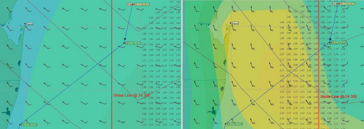
2017 Alba - When we were two days from Richards Bay, we had a strange anomaly in our GRIB files. I downloaded a low resolution (2.5 degree) GRIB in the morning and then a few hours later, I downloaded a high resolution (1.0 degree GRIB). The difference was astounding.
The low resolution GRIB showed no strong southerlies, while the high resolution GRIB showed a strong shear line with 20-30 knot south winds to the west of us. We turned south, stayed to the east of the shear line and avoided the strong head winds.
I'm not sure why there was an anomaly, but in future, I'll be getting a low res GRIB file for a large forecast area and a high res GRIB file for my local area.
4. NAVIGATION
4.1 Electronic Charts

We use OpenCPN with CM93 charts and Navionics charts on our 8” Samsung Tablet and our Raymarine Chart Plotter.
Both the CM93 charts and Navionics charts can be very inaccurate in this area, showing very little detail and can be out by up to ½ mile - they are okay for rough planning. Therefore I'm a great advocate for the use of satellite images for navigation.
There are several ways to do this, but the method I prefer is to produce KAP charts from Google Earth to use in OpenCPN.
The image shows our track in a remote part of the Anambas Islands, viewed with a CM93 chart and a KAP chart.
My KAP files can be downloaded from:
http://www.thehowarths/cruising-information/downloads
We have a separate article, if you are interested in more detail:
http://www.thehowarths.net/cruising-information/technical-notes/494-kap-charts-and-opencpn
5. MOZAMBIQUE ANCHORAGES
5.1 Introduction
2015 Gambit - Bazaruto (12 30S) and Inhambane (23 40S). Both give good shelter during SW gales, but bear in mind as the wind passes Maputo up to these areas it is bent by the land mass and becomes more S/SE. Very seldom do you get a true SW in these areas. The tide and consequent over falls in narrow channels due to a 3-4m tidal difference makes entry into and out of these areas critical.
DO NOT ATTEMPT ENTRY OR EXIT EXCEPT ON A RISING TIDE!
Whilst navigating behind Bazaruto or the headland at Inhambane, always start the trip on low tide, as if you get jammed the tide will lift you in a couple of minutes. In addition, a low tide allows you to navigate visually as the sand bars are clearly visible.
5.2 Diaz Point (21°08.858S 35°06.621 E)
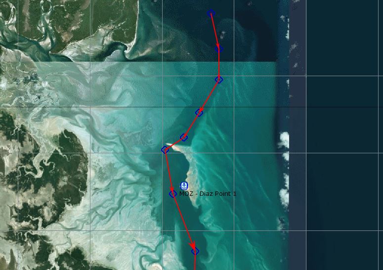
2015 Gambit: The spot is generally known as Bartholomew Diaz/Diaz Point and is a sheltered river mouth which is protected by a spur of land projecting in an easterly direction from the main land and then extends north protecting the river with sand bars and some dry land.
Up until 2007 this spur of land had a road on it leading to a lodge built on one of the substantial “islands” connected to the mainland with extensive sand bars etc. The area was ravaged by a cyclone in 2007/8 which destroyed the access road and the lodge and remodeled the entire area to the extent that it has taken close on 10 years for nature to put it all back together. It is only in recent times that the local yachties have been frequenting this spot during extreme weather and is now a viable alternative to the shelter behind Bazaruto.
Advantages - Apart from the shelter, it is removed from the islands and being isolated takes the yachties out of reach of the corrupt officialdom. In addition when the weather turns, it is lot less complicated to get out from a time point of view and head south.
Interestingly, this spot was used by Japanese submarines as a refueling stop during WW2 and I had the opportunity in 1969 during my first visit to Vilanculos to meet the son of the guy who was involved. He was the owner of the Donna Anna Hotel in Vilanculos, which he inherited from his father.
Waypoints:
- 21 04.3805 S 35 07.3633 E
- 21 05.3079S 35 07.5864E
- 21 06.0927S 35 07.5897E
- 21 06.9542S 35 07.0319E
- 21 07.5948S 35 06.6061E
- 21 07.9150S 35 06.0791E
- 21 09.0629S 35 06.3023E
- 21 10.5453S 35 06.9203E
- 21 11.9091S 35 06.8893E
- 21 13.1445S 35 06.7623E
- 21 14.2678S 35 06.5873E
- 21 14.9365S 35 06.3125E
Anchorages
1 21 08.86S 35 06.6215 E
2 21 15.47S 35 06.5187E
The normal caveats apply as far as entering/exiting only on an incoming tide and visual navigation is required paying particular attention to draft and depth.
5.3 Santa Carolina Island, Bazaruto Bay (21°37'S 35°20'E)
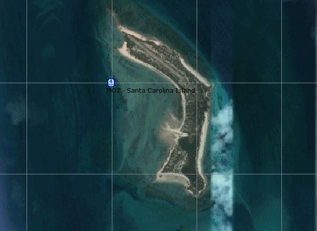
Ocelot 2007 - Our final challenge was that we arrived at the entrance to Bazaruto Bay at full ebb tide, so this brought the current against us. The outer anchorages would not have been protected with the prevailing easterly winds, so we had to go 9 miles inside the bay, with a 2 knot current against us, to anchor. We arrived about 10 minutes before absolute dark and anchored in 27' (9m) at 21°37'S 35°20'E, behind Santa Carolina (Paradise) Island.
We had to weather a nasty 40 knot southerly squall (which had us scurrying around to the other side of Paradise Island in the middle of the night). We'll probably go do some exploring until our next weather window lets us hop south.
2013 Two Oceans: Saturday – With daylight the way to Santa Carolina island, again at close to low water, was less intimidating but still we had to dodge some shoals that were not indicated on the chart, as the red line on the chart shows. At one point we crossed a bar 1.6 meters deep, which my eyes told me was O.K to go over. Coming into the western side of the island, we saw s/v Myriam at anchor. We met Annie, Jerry and their two boys, William and Oliver, who are French Canadians, in Chagos and then again along the way to Mozambique.
Santa Carolina, according to the guide I have, used to be a penal colony and deserted buildings and structures are all over the place. A sign on shore proclaims the project of "rehabilitating the island" but no meaningful steps in that direction could be seen.
Sunday – In a very early hour we woke up by the violent movement of the boat and the shriek of the wind. I rushed out and saw a strange phenomenon; the wind came from the south at 29 knots but the boat was facing north, pushed by the mighty tidal current. This went on almost all night and there was nothing we could do but hope that the anchor will hold, which fortunately it did.
5.4 North Entrance into Bazaruto
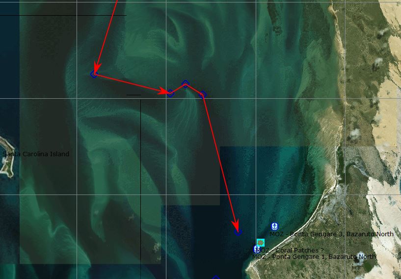
2015 Gambit: North Entrance Bazaruto. You will use this entry with a strong S/SE imminent or already there, but usually with the NE still blowing. Starting on a low tide with sand bars visible, proceed to the first anchorage with good NE/SE protection.
Entering the north channel set out at low tide or incoming tide during daylight and don’t cut corners. One yachtie with a 2m draught got jammed between the last wpt and the anchorage due to taking a short cut.
Entrance Waypoints:
- 21 30 00E 35 25 00S
- 21 32.50E 35 23.40S
- 21 35.50E 35 22.40S
- 21 35.90E 35 24.10S
2017 Alba: We started our approach into the channel one hour before low tide, following a set of way-points published by Des Cason. They were spot on, but we were eye-balling the water depth all the time, using the colour of the water. There are many sand banks along the 12 mile route, but the water is clear and the lighter colour of the shallow spots is easy to see. We had to do a bit of a dog-leg around one shallow sand spit - 21°35.711S 035°24.441E and 21°35.930S 035°24.819E gets you around it.
All our way points were:
- 21°30 00E 35°25 00S
- 21°32.50E 35°23.40S
- 21°35.50E 35°22.40S
- 21°35.90E 35°24.10S
- 21°35.711S 035°24.441E
- 21°35.930S 035°24.819E
- 21°38.77S 035°25.60E
5.5 Ponta Gengare 1, Bazaruto (21°39.13S 35°26.04E)
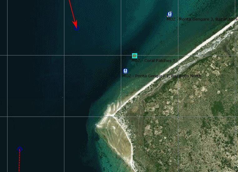
2015 Gambit: (21°39.13S 35°26.04E) This has good NE/SE protection. You can remain here till the wind switches, but this will put you in sight of the conservation authorities who will try and extort cash out of you for being inside a conservation area ($10 per person last we heard). When it is time to leave it can take you up to 6-8 hours to get out as you may have to wait for the tide – time you can ill afford when sailing to a deadline and your next safe spot.
We recommend you move from this anchorage to the one south at Benguerra Island which is more relaxed.
2017 Gambit (eMail) - At best spend one night at Punta Gengarema and move to Benguerra Lodge as soon as possible. The Bazaruto lodge (at Punta Gengarema) is of the opinion that us grotty yachties lower the tone of their establishment so are anything but welcoming. We are also notoriously tight with cash and don’t spend as if there is no tomorrow.
Why pay their inflated prices for a cold frosty and surly service when you can have them at wholesale price on the back deck. Bazaruto lodge is also known for tipping off the local “Nature Conservation Official” and he will be on your back to collect his $10-15 per head which needless to say goes into the back pocket as official receipts are unheard of.
On the other hand, Benguerra lodge has always welcomed yachties as the charter fleet normally is based there and they have been “detribalized” They even allow you to run a “tab” at their pub !
2015 Yolo - Sailboats typically approach Bazaruto Island from the north and end up anchoring on the west side of the island. The approximate anchorage location is 21.38.9S and 035.26.1E. Bazaruto is a very large island with just a few locals on it. It is a huge high sand dune which stretches for kilometers.
The anchorage can handle dozens of boats at the same time. Anchor in 8 to 10 meters of water. The bottom is endless sand and the holding is great. Just what you need when the winds are 30+ knots out of the south for days on end. Put out plenty of scope and don't crowd your neighbour because the winds are often very strong.
You might get a visit from several guys who claim to be from the local Marine Park. It appears that they only approach yachts when the weather is settled, so that they can stay dry during their money collecting round. Their clothing and vessel certainly fails to give you the feeling that they are "official" park employees. In November 2015, SOME yachts were asked to pay a Marine Park Fee of $47.30 USD. The fee was payable in local currency, U.S. dollars, or South African Rands. There are no local ATMs or banks at this anchorage. They did not approach or ask for payment from about half the boats during my stay at Bazaruto. Those that paid did get a paper receipt. None of the yachts were requested to officially clear into the country.
2017 Alba: We were all planning to head down to an anchorage at Benguerra today, but the prospect of SSW winds made us rethink because Benguerra might not be so good in that wind direction.
After some debate, our mini-fleet upped anchor and sailed back north a couple of miles to anchor to the North of Ponta Gengare, which is better protected from the SW. We dropped our anchor at 21°38.66S 035°26.43E in 5 metres on a huge area of good holding sand. (There’s a recommended anchorage closer to the point, at 21°39.13S 035°26.04E, but there seemed to be too many coral patches for my liking.)
At 02:00, the wind veered around to the south and picked up to 25-30 knots, blew hard for a few hours and then settled down to 20-25 knots. As forecast, the wind was SSW and soon a swell was hooking around Ponta Gengare bringing in 2 foot waves from the south-west. This made it a bouncy, noisy night with the waves slapping on the side of the hull.
2013 Two Oceans. Deciding to go into the bay at night was not a light matter. The C-Map chart for the area is not very detailed and Santa Carolina Island, where we thought of making our first anchorage, had no depth information at all. I spotted a bight on the west side of Bazaruto Island, to which there was an approach with no obstacles and where the bottom shoaled gradually towards shore from 7 to 2.8 meters.
Approaching the entrance to the bay the conditions did not ease at all; the wind rose to 35 knots and with the shoaling bottom the sea built up menacingly. The moon came up red and almost full on the eastern horizon, lighting the scene in a surreal way. I followed the route on the chart-plotter, eyes glued to the depth gauge. Passing an area of 4 meters at night, having to put your trust on the chart and not able to see anything was nerve wracking. Add the fact that the sea was far from calm and you have the perfect precondition for a heart attack.
Frankly we had no other choice but to go in; staying outside with that rough sea, waiting for the morning, was out of the question. At the depth of 4.5 meters I thought that we were as close to shore as we should go and dropped the anchor. the time was 0100. A sip of whiskey to lower the adrenalin level and off to bed.
5.6 Ponta Gengare 2, Bazaruto (21°40.39S 035°25.87E)
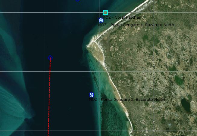
2017 Alba: (21°40.39S 035°25.87E) There was a strong NNE15-20 knot wind when we arrived and the anchorage on the north side of Ponta Gengare was very exposed. We dropped the anchor in 12 metres (10.5m LAT) - this was a fairly calm anchorage with a little swell hooking around the corner.
The next day, we went ashore. It was approaching low tide when we landed ashore and the water was very shallow a long way from shore, so we had to carry the dinghy 100m from the water’s edge and left it high and dry to fend for itself. As we walked onto the dry beach, we attracted a lot of attention and a small crowd of adults and kids soon gathered, but mostly kept their distance with a few braver children approaching us.
Being low tide, the beach was a hive of activity. Kids were digging for lug worms for fishing bait and people were wading in the shallow water looking for clams, which they dry on platforms on the beach. A couple of National Park wardens came over and chatted to us in broken English - they speak Portuguese, but neither of us speak that language. The wardens were very friendly and nicely told us that we would have to pay $10US per person (plus $20 per boat) entry fee into the National Park. We said sure, but we had no money with us, so they’ll have to come out to the boats later.
The island of Bazaruto is mostly made of huge sand-dunes and it was a very steep climb up to the village above the beach. The villagers live in round huts called Rondavels made from wood and some kind of cane - we’re definitely in Africa. We walked around looking at the way of life on this barren island. The people appear to live in family groups with a few Rondavels for living/sleeping and one Rondavel for cooking. Each family had a rough set of shelving outside their cooking hut which held the pots and pans.
It was very arid, sandy ground, but we saw coconut palms and payaya trees growing. Each family has a garden area where they looked to be growing some kind of yams. The Park Wardens said that the villagers survive by exporting sea food to the mainland, which is used to buy rice and vegetables. It looks like a tough life living on a sand-dune.
5.7 Ponta Milixa, Bazaruto (21°42.56S 035°25.86E)
2017 Alba: The wind is forecast to be NE 15 tonight and tomorrow morning, but will then veer around to 20+ knots from the south tomorrow night. The plan is for our small fleet to move tomorrow to an anchorage at Benguerra Island 10 miles further south, which we hope has good protection from the strong southerlies.
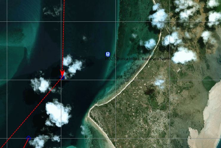
So, we all moved a couple of miles further down the coast to an anchorage at 21°42.56S 035°25.86E (7m LAT on good holding sand). The anchorage wasn’t as good as the previous one and it was a bit bouncy in the NE20 winds at sunset.
The NE wind continued blowing strongly until the early hours of the morning and, to make matters worse, the current switched at midnight and turned us so that our stern was pointing into the wind and the waves. We have a “sugar scoop” stern, which is a low angle extension to the hull, designed to increase the waterline length and make the boat sail faster. Unfortunately, it’s hollow and when waves slap underneath it, the loud bang is amplified and it sounds awful in the back cabin where we sleep. There’s nothing worse than being “slapped up the sugar scoop” to keep you awake.
After breakfast, the Park Rangers arrived in a small power boat and we had to pay $10US per person and $20US for the boat - we didn’t escape after all. I tried to negotiate them down and didn’t want to pay for the boat, but they produced an official looking receipt with the tariffs clearly shown, so I paid up. We’re not cleared into Mozambique, so we want to keep a low profile and don’t want any trouble with the local officials.
A cynic might say that the money we paid out will go into their pockets, but we’re clean - we’ve paid what we should officially pay. I’ve heard that one scam is to put a piece of card behind the carbon paper, so that nothing is imprinted on the “office copy” of the receipt book. They then later write in lower figures on the “office copy” and pocket the balance. On the other hand, they may be honest…
5.8 Punta Gengare to the South Exit
2015 Yolo: You have several options for exiting Bazaruto.
1. Sail North, East and South, around the northern end of the island, retracing your entry route through the channels. This certainly take several hours in good winds.
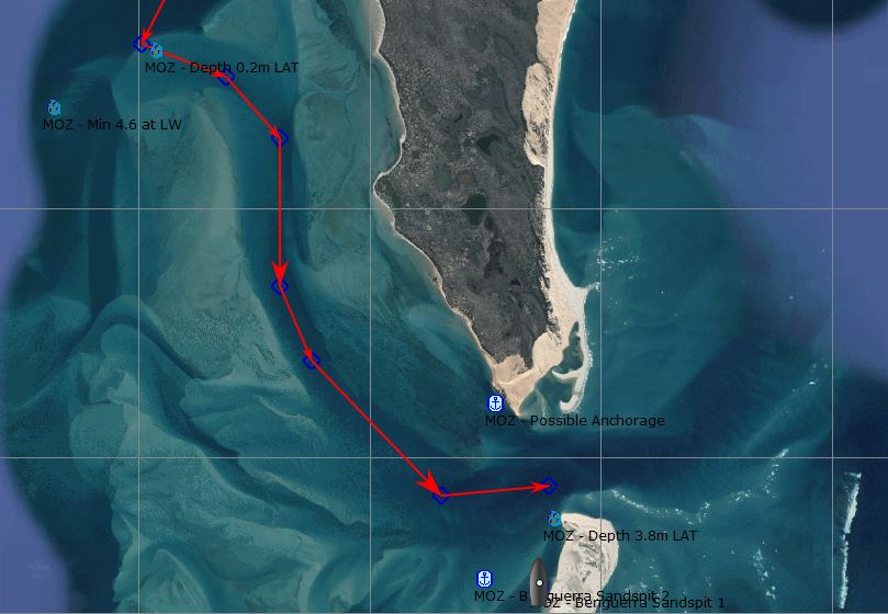
2. Sail/motor out the pass at the southern end of Bazaruto Island, via the northwest channel. This is the quickest way to leave the area. Nine yachts used this course during November 2015 and the minimum water depth I saw at mid-tide was 3.4 meters, which only lasted for 2 short distances. Most of the time the water was 10 meters deep or more. The waypoints that I and others used were:
- 21 44.0S 035 24.4E
- 21 44.4S 035 24.4E
- 21 44.9S 035 24.5E
- 21 45.3S 035 25.2E
- 21 47.0S 035 25.3E
- 21 47.5S 035 25.7E
- 21 48.4S 035 26.8E
- 21 48.0S 035 28.6E
- 21 47.6S 035 29.7E
3. Sail/motor out the pass at the southern end of Bazaruto Island, via a channel near Ilha De Santo Antonio Island. Numerous historical documents distributed among yachties reference this departure method and related waypoints. This exit strategy will take you at least 1 hour longer than Option 2.
Departing Bazaruto Island during a strong easterly wind can be very challenging. Especially when crossing the outer channel bar for Options 2 and 3 noted above.
2017 Alba: From Benguerra, we didn't like the look of the shallow water on a direct route to the anchorage by the pass, so we headed back north, re-tracing our route and then looping back south along what looked to be a much deeper and safer channel. It was 15 miles, but we were hoping that our destination would be a well-protected anchorage and it’s close to the pass that we will use when we finally go out to sea.
The start of the route south goes over a shallow sand bar and we were unsure what the depth would be. Fortunately, there was a local sport-fishing boat going out and he told us that he had a minimum depth of 3.4m over the bar. We put a trace on his AIS and followed his track over the shallows and then down the channel - I love AIS. The minimum depth that we saw was 3.4m (0.2m LAT) and most of the route was over 7 metres deep.
Our waypoints were:
- 21°44.68S 035°24.03E
- 21°44.95S 035°24.76E
- 21°45.44S 035°25.22E
- 21°46.63S 035°25.23E
- 21°47.23S 035°25.50E
- 21°48.31S 035°26.62E
- 21°48.48S 035°27.59E
- 21°48.67S 035°27.60E
- 21°48.92S 035°27.51E
5.9 Route from Punta Gengare to Benguerra
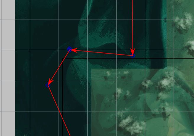
2017 Alba: At midday, the fleet of 5 boats set off for Benguerra, 15 miles south. The route was a little torturous passing through a shallow area, where we did a dog-leg west, but the minimum depth that we saw was 4.5m at low tide (3.2m LAT).
Our waypoints were:
- 21°42.96S 035°25.02E
- 21°44.78S 035°23.33E
- 21°45.46S 035°23.28E
- 21°46.73S 035°23.12E
- 21°46.49S 035°22.19E
- 21°47.07S 035°21.83E
- 21°51.20S 035°23.75E
5.10 Benguerra Island, Mozambique (21°51.25S 35°24.60E)
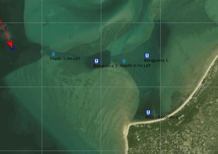
2015 Gambit: Benguerra Island (21 51.25E 35 24.60S) is a lot more relaxed and also gives you access to the lodge and a local shop for basic provisions.
From the Northern anchorage navigate visually on low tide approx. 180T according to your charts, which will have one shallow patch at approx 21 46S. As there are a number of yachts moored here you get lost amongst the crowd and duck the officials - they don’t pay attention when there is a crowd.
2017 Gambit (eMail) - Benguerra lodge has always welcomed yachties as the charter fleet normally is based there and they have been “detribalized”. They even allow you to run a “tab” at their pub !
There is a small shop for basics and fresh Portuguese Prego rolls and water from the lodge. You become part of the crowd so no one as a rule hassles you. Your closest officials are in Vilankulos 15nm away on the mainland and they are too lazy to come and check and they invariably don’t have fuel for their boat. The shelter is pretty good except in true SW, S/SE is no problem.
Whenever you move during your sojourn always leave on a low tide as this makes the sand bars and channels more visible and even if you do get jammed the tide coming in will lift you off. Bear in mind average tidal difference 3.5-4.5m.
Whoever stated that the channel between 2Mile Reef and Pansy Island breaks either has not been there or tried this passage on an outgoing tide (suicide).
Check with the local charter guys as far as the channel is concerned as they will have the updated co-ords. Whilst they change over time the deviation is so small (2-3m either way at best).
2017 Alba: The entrance into the anchorage was very shallow. There’s a 0.4 mile long channel leading to a deeper “pool”, which went down to 2.4m (1.0m LAT) at one spot. “Red Herring” and “Luna Blu” anchored in the 7m deep pool, which is ¾ mile from the shore and exposed to the south, so we went further to see if there was somewhere closer to shore to anchor. Unfortunately the depth dropped to 2.1m (0.7m LAT), our draft is 2.0 metres, so we turned around and anchored back with the rest of the fleet. We slowly dragged (on weed?) a couple of times before settling at 21°51.29S 035°24.42E in 8 metres of water.
It’s not a very good place to be. We’re ¾ mile from land and exposed to the forecast SSE winds; the “pool” that we’re in is only 200m wide and surrounded by very shallow water. I’m not a happy bear. If the wind picks up from the south tonight, then it will be very, very unpleasant. The plan is to go to another anchorage tomorrow morning. High tide is at 09:00, so we’re planning to weave our way through the sand bars starting at 07:00.
As it was Graham’s birthday, we all piled into dinghies and went ashore hoping to be able to buy a beer or even have a meal at the "friendly" holiday lodge ashore. It was actually an up-market resort catering to honeymooners, so we weren’t allowed to buy anything. After a short walk on the beach, we retired back to “Red Herring” for a rum or three.
“Continuum” and “Mowana” with their shallower drafts, elected to stay at an anchorage a little closer to shore (at 21°51.27S 035°24.90E in a depth of 2m LAT). "Continuum" went ashore and a guy at the resort guided them to a local village where they were able to buy a few items - Coca Cola and a couple of bottles of the local beer, but not much else. They couldn't find the "friendly" lodge that Des Cason talks about - we think that it's the closed lodge at the west end of the beach.
Ocelot 2007 - (21 51.70S 035 24.90E) So we moved to Benguerra (Santo Antonio) Island, just south of Bazaruto Island. Getting there was quite interesting as much of Bazaruto Bay is very shallow, so we left on a rising tide with the sun high so we could see and dodge around shallows and sand-banks. We actually visited 2 anchorages off Benguerra, the first at 21°51.7'S 35°24.9'E where we spent several days exploring, playing on the sand dunes, hiking, birding, shelling, helping the 2 small resorts with their computers, and visiting with a neighboring catamaran. Note: Catamaran with very shallow draft.
5.11 Benguerra Island to the South Exit
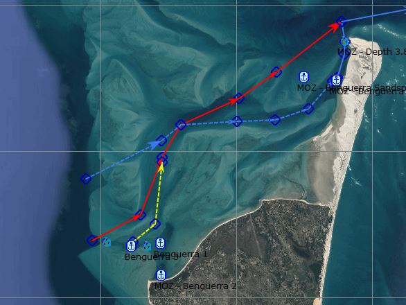
2015 Gambit: The exit from here is via a narrow channel between the 2 islands and past the north of 2 mile reef and puts you out in deep water within an hour.
EXIT Channel (RED Route in Image):
- 21 51.2813E 35 23.7465S
- 21 50.7555E 35 24.6186S
- 21 50.0799E 35 24.9069S
- 21 49.1493E 35 25.9609S
- 21 48.9189E 35 26.5961S
- 21 48.2536E 35 27.4785S
- 21 48.0209E 35 27.9522S
- 21 47.6193E 35 29.5042S
- 21 47.7851E 35 30.3144S
2017 Alba - We were up at 05:15, with the wind at 10-15 knots from the south bringing 2 foot waves into the anchorage. There was a discussion on the VHF and the consensus was to move at 06:00 - three hours before high tide. We had some waypoints through the sand banks to our next anchorage, which were a mixture of some waypoints from previous cruisers; information from a local boat; and inspection of Google earth images in KAP Charts. (YELLOW Route in Image then Blue)
The route looked deeper than 5 metres for most of the way, with the shallowest point being at the beginning. A local boat had told us that there’s a channel heading NE from our anchorage, but it didn’t look promising with wind waves and overcast, early morning skies. I dropped our dinghy into the water and picked up Graham from “Red Herring” to go and look at the “channel” using our portable depth sounder.
It wasn’t good. We recorded depths of 2.1 to 2.4 metres and it looked shallower further on. We were at half tide with a tidal depth of 2.5m. We’re approaching neaps at the moment and high tide is only 3.2m. Graham and I agreed that it was too risky to head off across uncharted sand banks especially because the strong wind would be pushing us forward and making it hard to stop. Not that I’m superstitious, but it’s also Friday the 13th…
There was a rapid change of plans. “Red Herring”, “Luna Blu” and we headed back north, re-tracing our route and then looping back south along what looked to be a much deeper and safer channel. It was 15 miles, but we were hoping that our destination would be a well-protected anchorage and it’s close to the pass that we will use when we finally go out to sea.
2017 Alba - A couple of days later, Continuum took the BLUE route, two hours before high water (tide 2.7m) and saw 3.0 metres (0.3m LAT) at the start and then over 5 metres (2.2m LAT) for the rest of the way.
5.12 Benguerra Sand Spit (21°49.03S 035°27.48E)
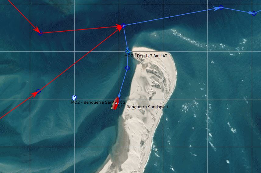
2015 Gambit: You can move to an anchorage behind a substantial sand bar right at the entrance (21 49.26S) prior to the weather actual turning in your favor. We have sat behind this sand bar in 9m of water in 40kts SE and were as safe and comfortable as can be.
2017 Alba: We entered this anchorage from the north. The anchorage is close to a long sand spit and there’s a shallow-looking sand bar to the west of it, so we sailed very close to the end of the sand spit and then along the shore. The minimum depth that we saw was 7 metres (3.8m LAT), so we’ll be able to get out of the anchorage and into the pass at any state of tide.
Our waypoints were:
- 21°48.23S 035°27.55E
- 21°48.50S 035°27.60E
- 21°48.67S 035°27.60E
We anchored at 21°49.03S 035°27.48E in 10 metres on good holding sand. It’s a huge anchorage about 0.5 miles long by 0.2 miles wide. The sand spit is a beautiful set of sand dunes - white coral sand, tufts of grass and nothing else. By the time that we arrived at the anchorage, the wind was blowing 20-25 knots from the SSE, but we were very comfortable with just 1 foot wind waves and no swell.
After lunch, we had a quiet afternoon, catching up on some sleep and reading. Our relaxation was interrupted by some Park Rangers stopping by, wanting us to pay park fees. We produced the receipt from the rangers at Bazaruto and they were happy. So it is an official fee…
The next day (Saturday), the North-east wind picked up through the morning and, by lunch-time, we had 20 knots, which was raising 2 foot waves in the anchorage. There was a quick discussion on the VHF and then we all left and headed across to the south west corner of Bazaruto to Ponta Dundo.
Monday - After a restless night at Ponta Dundo, we returned to the Sand-spit anchorage. We had a bouncy trip across, but it was only a mile or so. Once in the anchorage, the waves settled down and it seemed okay. We reported back to the rest of the fleet and they all decided to come over to join us.
Unfortunately, by 15:00, the tide was going out and once again, we had strong tidal currents pushing us against the wind. The afternoon was unpleasant with the boat pointing sometimes downwind and sometimes sideways with NNE 20-25 knot winds hitting our stern. At least this anchorage has more space and we’re not close to a rocky shore.
The wind is forecast to continue from the NNE until tomorrow afternoon, when it will slowly veer to SE - I can’t wait because this anchorage will be nice and flat again. The SE wind will continue at 20-25 knots for 36 hours and, by the morning of Thursday 19th, the wind will have reduced to E 10-15. Fingers crossed, that’s when we will start heading south towards South Africa.
The wind blew at NNE 20 all night which was OK until the tide started to go out at 03:00. Our bow turned south into the strong current and the waves remorselessly slapped our stern. The boat would turn slightly and then sail across the wind, heeling over 5 degrees. A few minutes later we would gybe, with some resounding slaps up the sugar scoop and then slowly sail the other way, heeling over degrees to the other side. It was irritating.
Tuesday - We dragged ourselves out of bed at 07:00 and all the boats were still pointing downwind with waves hitting our sterns. After breakfast, we went for a long walk with “Red Herring” - the other boats in the anchorage politely declined when we started talking about making sandwiches and taking lots of water for the hike.
Our aim was to walk 3½ miles along the windward beach to the huge sand dune at 21°52.17S 035°27.20E and hopefully find a lake that has Flamingos. We had a pleasant walk along the beach and, after a couple of miles, just past a small pine-tree wood, we headed up into the lower sand dunes, where we could see a path leading inland. A local guy shouted to us and said that he would show us the Crocodiles, so we went with the flow.
Our guide led us along narrow paths which eventually came out to the south end of the larger of the three lakes. On the way, I enquired about palm trees that had been chopped down to a few feet, the tops of which were covered by small baskets. He showed us that they were extracting some kind of sap from the palms, which was turned into some sort of mildly alcoholic drink. He gave us a taste of the finished product which was quite pleasantly bitter reminiscent of lemon.
We were then led around the west side of the larger lake, but alas the crocodiles weren’t to be seen. Our guide led us to the smallest lake, which is directly below the huge sand dune, where there was a solitary Flamingo, so I took some photos and we said goodbye to our guide. We hadn’t expected to meet any one, so we hadn’t taken any “gifts” with us, but Karen gave the guy an old pair of sunglasses, which he seemed pleased with.
Our next objective was the huge sand dune, which I guess is a few hundred feet high. The first section up the face was very steep, but once on the ridge it was easy going. The sand dune is a bizarre geological formation, isolated and high above the rest of the land - I have no idea how it would have been formed. We had our sandwiches on the summit, staring at the fabulous view.
After a long walk back along the beach, we arrived back at the boat at 13:15 - a 4½ hour trek, so we were shattered. However, no peace for the wicked - it was high tide at 14:30, so we had slack tide at 14:00 and had to jump in the water to scrub the hull and replace the anode on the propeller. As well as the usual green slime, we’d picked up an impressive collection of goose-neck barnacles, which had to be scraped and scrubbed off.
By 14:40, the tide had changed and there was a significant out-going current, which brought the job to an end. We’d managed to remove most of the barnacles, but we need to have another go tomorrow. We chilled out for a few hours and went ashore for a sunset beer or two.
Wednesday - Overnight the wind veered to the south-east and picked up fast. Just after midnight, I was woken by the uncomfortable motion and found that the wind was blowing 25-30 knots with the tide against the wind, raising 2-3 foot waves. By dawn, the wind was blowing hard from the SSE at 30 knots gusting to 35 knots, so it was gnarly.
The weather forecast looks good. These strong SSE winds will start to abate this afternoon and then will back to ENE 10 by morning. We’re still planning on leaving at 14:00 tomorrow and the first night of our passage should be ENE 10.
5.13 Ponta Dundo (21°47.63S 035°27.14E)
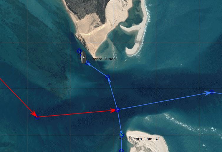
2017 Alba: The North-east wind picked up through the morning and, by lunch-time, we had 20 knots, which was raising 2 foot waves in the anchorage. There was a quick discussion on the VHF and then we all left and headed across to the south west corner of Bazaruto to Ponta Dundo. There’s a deep water channel quite close to the shore next to some trees and the least depth that we saw while going across was 7 metres.
We anchored at 21°47.61S 035°27.12E in 12 metres (9m LAT) on what felt like good holding sand. There’s a swell hooking around the corner making it a bit bumpy, but it’s definitely much more protected from the North-east winds than the previous anchorage. Ashore is a huge sand dune that is obviously a tourist attraction, judging by the number of local boats and tourists milling about.
Our waypoints were:
- 21°48.22S 035°27.56E
- 21°47.87S 035°27.44E
- 21°47.72S 035°27.20E
It was low tide at 18:00, so the bouncy waves reduced and we had calm conditions for our dinner. However, by 21:00 the tide was coming in at full flood, so the boat turned to face south with the wind from the north-east, making our rigging rattle and shake. It didn’t bode well for the night.
It was a turbulent night as the tide pushed us back and forth. When the tide was ebbing we pitched into the wind; we rolled when we were sideways; and we were slapped up the sugar scoop when the tide was coming in. However, the wind was only 20 knots, so it was just very uncomfortable and not dangerous.
After breakfast, we went for a walk with “Red Herring” up the huge sand dunes. It was fabulous walking along the wind-swept ridges of pristine sand. It was very reminiscent of walking along snowy arêtes in the Alps, but we were blasted by sand instead of snow by the strong NE winds. From the top, there was a good view of our proposed route out to sea, which goes over a sand bar, but it was hard to see the best route through the many sand banks, some of which were breaking.
After a short stop overlooking a small lake packed with Herons and Ibis, we walked down to sea level and strolled back along the shoreline. When we arrived at the anchorage we could see mayhem as the boats were all pirouetting around in the strong current against the wind. Alba looked very close to “Luna Blu” and we couldn’t see whether or not we’d dragged, so we rushed back to the dinghy.
We hadn’t dragged, but it was very unpleasant on board. We were bouncing about, lying side onto the wind and “Luna Blu” were sailing around on their anchor - sometimes they were 100 metres away and within five minutes they’d be 20 metres away. I didn’t fancy the prospect of another boisterous night being only 80 metres from the shore, so we upped anchor and headed back to the sand spit anchorage.
5.14 The South Exit from Bazaruto
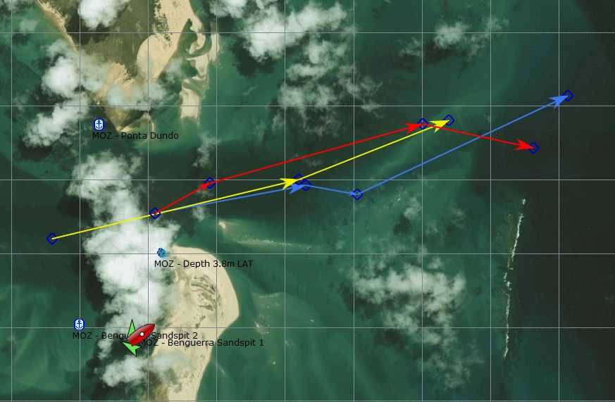
2015 Gambit - Exit waypoints (RED):
- 21 48.2536E 35 27.4785S
- 21 48.0209E 35 27.9522S
- 21 47.6193E 35 29.5042S
- 21 47.7851E 35 30.3144S
2015 Yolo - Exit Waypoints (YELLOW):
- 21 48.4S 035 26.8E
- 21 48.0S 035 28.6E
- 21 47.6S 035 29.7E
2017 Alba - At dawn, the wind was 10-15 knots and then slowly backed to the NE. We spent the morning tidying up, running the watermaker and getting ready for sea. There wasn’t much to do, so we were ready to go by 11:00 and then had to wait for the tide, so that we could get over the sand bar in the pass.
We were planning to leave two hours before high water at 14:00. This would ensure that we had an incoming tide which would flatten the incoming swell from the east. The worst time would be to try to leave in an out-going tide, which would mean that the current was against the swell and would cause steep “overfall” waves. The other factor in our timing was that, just before high tide, the tidal current would be less and we would have more water over the bar.
“Luna Blu”, “Continuum” and “Fortuna” cracked up early and left the anchorage at 12:00. The least depth that they saw was 5 metres and the sea was fairly calm, but they had to battle against a strong current over 3 knots. “Fortuna” have an engine problem and can only run at low revs, so they were only making 1.5 knots over the ground.
We were good little bears and stuck to the plan, pulling up our anchor at 14:00 together with “Red Herring” and “Mowana”. There was still a strong 3 knot current against us in the narrowest part of the channel between the two islands and the water was very turbulent, pushing us around. However, it calmed down to 0.5 to 1 knot after that and we made good progress - the waves also settled down to a smooth 1 metre swell.
A few days ago, we tracked a sport fishing boat on AIS, going out of the southern pass and had a conversation with the skipper about the depths. He reported that the shallowest point was 5 metres. We decided to follow his route (BLUE), which went along a channel to the south of the shallowest sand bar - the lowest spots were 6.5 metres (2.5m LAT) in a few places after 21°48.10S 35°29.05E.
Our way points were:
- 21°48.23S 35°27.55E
- 21°48.05S 35°28.09E
- 21°48.10S 35°29.05E
- 21°47.56S 35°30.21E
- 21°48.06S 35°31.02E
Once clear of the bar and in deeper water, we turned SSE and reached away from the reefs. There was a smooth 1-2 metre swell from the east; east 10-15 knot winds; and we had current with us, so we made good progress doing 6.5-7.5 knots over the ground up to midnight.
5.15 Linga Linga, Inhambane (24°44.149S 35°23.692E)
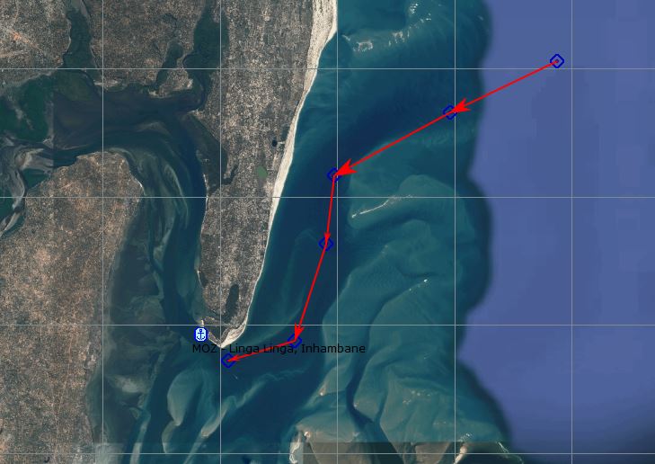
2015 Gambit - Anchorage at 23 44.149E 35 23.692S
Entrance to LingaLinga anchorage:
23 39.888E 35 29.755S
23 40.680E 35 27 928S
23 41.661E 35 25.951S
23 42.736E 35 25.821S
23 44.251E 35 25.285S
23 44.559E 35 24.146S
2017 Gambit (eMail) - We have been in Linga Linga twice during hectic SW/SE gales there are some major drawbacks you should take into account.
The sand bar with depth at LAT of .4m bearing 225T +- .6nm from fairway buoy 23 39.899S 35 29.726E can only be crossed 1-2 hours before high tide. Do not attempt on outgoing tide !!
There is a small village and fishing lodge at the point which is frequented by locals who inform the authorities in Maxixe and Inhambane of your presence and before you know it you have them on your back with their hands out demanding all sorts.
I was fortunate to spend 2 weeks at the lodge in the late 90’s and got to know the sand bars and effect of tidal flow quite well. Most of the channel markers are non existent and the water flow in and out the bay and river system to the NW of the point is impressive.
The major drawback is the tide as you can only leave on the incoming tide and as happened to us once this meant a 5 hrs delay in getting out which cut down our time to get to Rbay before the next SW/S came through.
Those 5-7 hours you lose is quite often the difference between squeaking in and getting hammered 20-30 miles out of Rbay. Anchorage at LingaLinga SW of wreck on beach 23 44.243S 35 23.641E
2015 Yolo - About 140 nm south of Bazaruto is Linga-Linga and Barrow. Some yachts seek shelter at these locations. Linga-Linga is located near 23.44.5 South and 035.24.1 East. Barrow is near 24.46.5 South and 035.30.8 East. Yachts which went to both locations in 2015 reported good holding. Those that anchored near Linga-Linga enjoyed better protection from the screaming southerly winds and waves. Locals did not approach the yachts at these locations.
5.16 Barrow Point, Inhambane (23°47.33S 35°31.198E)
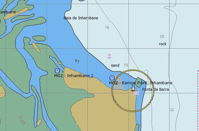
2015 Gambit: Inhambane /Ponta Barra: Arriving in a S/SE anchor on the north side of the headland just to the west of the light house in front of the lodges in 7-10m (23 47degS). This gives you very good protection and once the wind switches to ESE leave on a beam reach on 060T until the wind turns more E and eventually NE.
If you arrive on a NE with an impending S/SE due, you have 2 choices. You can slow down to arrive at Ponta Barra as the S/SE arrives, or you will have to negotiate the entrance into the shelter of the bay and anchor at LingaLinga. This entry and exit again can only be done on an incoming tide and again you face a time delay in getting out when the weather turns in your favor.
Lying in front of the light house at the above co-ordinates is not impossible, but in a NE swell of up to 1.5-2 m is not comfortable. However if the arrival of the S/SE is imminent, it may be worth it to sail offshore and double back when the S/SE arrives.
2016 Adina: Good shelter from S/SW winds, less so from SE but fine. There is swell and with the coming and going of the tide, you often end up beam to the swell so expect lots of rolling. We moved closer to the beach 23 47.33S 35 31.198E trying to get more protection from some reef but it didn't make much difference. The holding is very good in sand.
You need to time your arrival to be anchoring once the winds have gone south. The swell can be quite large with winds from the north and put you on a lee shore. It takes a few hours for the southerlies to calm the swell down.
We departed when the winds went light and slowly started clocking east. There is definitely a coastal effect and grib files saying the wind would be 120 were more like 160. We set off upwind, but the winds were light so no problem.
Good favourable current approaching Inhambane and some great current going south. This fizzles out as you turn west towards Maputo.
We stayed inshore to avoid some strong winds forecast overnight which worked but watch out, the light winds on the gribs will likely be no wind!
5.17 Inhaca Island (25°57.60S 032°59.00E)
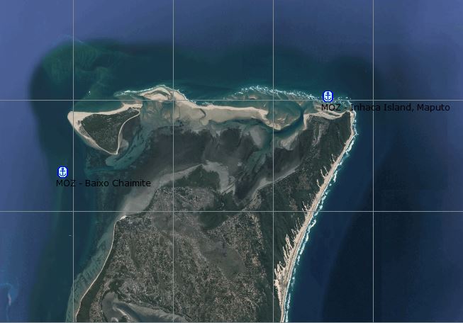
2015 Gambit: Inhaca Island (25 57.54 degS): Very good shelter in SW/S/SE right below light house in 7-10m. Line up the light house with the white lattice tower on the beach bearing 142T. Do not anchor on the west of the island at the hotel as the local naval chap will be on your back ASAP demanding all sorts.
If you are arriving in NE conditions, which as with Inhambane makes the anchorage uncomfortable, either slow down to arrive just as the SW/S arrives or sit it out for a while.
Take note that Baixo Danae (exposed reef) is a real danger and should be given a wide berth.
When your barometer tops out and the wind starts to turn SE, leave on a reach and as the wind turns to NE you are on the last stretch.
2017 Gambit (eMail) When travelling from Inhambane, you will lose the current just south of Pta D’Zavora and on the coast on approach to Maputo you could have 1 - 1.5 kts negative current, which is the top of the eddy which runs clockwise up the coast back to Zavora from +-Jesser Point 27 32S 32 40E. This accounts for the turbulence normally experienced at Zavora.
The anchorage at Inhaca is good providing you tuck in close in 6-8m as some of the S swell can wrap around the point. However in a heavy SW/S it normally gets blown flat for days and only once the deep ocean swell coming up from Cape Town gets there (2-3 days) you will be pretty comfy.
2015 Yolo - Maputo is the capital of Mozambique, and it's largest city. It is an official port of entry. It is about 250 nm south of Linga-Linga. In 2015 yachts avoided poor weather conditions by dropping their anchors in several locations:
1. Cabo Inhaca, 25.57.6S 032.59.0E
2. Baixo Chaimite, 25.59.3S 032.53.8E
3. Near downtown Maputo in the river, 25.57.6S 032.31.4E
Yachts at all three locations reported good holding. The downtown Maputo option certain exposes you to clearance officials. However, several yachts anchored here for three days to sit out ugly weather and were NOT required to clear in or out of Mozambique. One yacht was approached by a local marine police boat and asked to move several hundred meters to make sure that the yacht was outside of an unidentified marine park area. The crew of these yachts never ventured to shore.
It is about 200 nm from Maputo, Mozambique to Richards Bay, South Africa.
5.18 Richards Bay, South Africa (xxxxxxx)
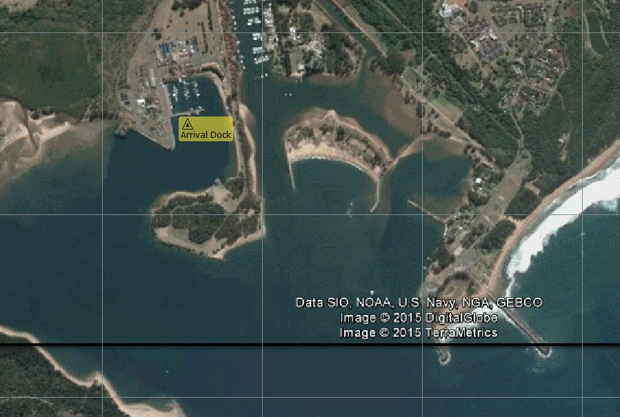
2017 Gambit (eMail) - To optimise the current you need to aim for Jesser PT (Sodwana Bay 27 32S 32 40E), which is the centre of the current for max boost.
From there stay 10-15 nm off up to Cape Vidal (28 08S 32 33E) and then close to within 3nm off Cape St Lucia (28 24S 32 26E). Then get into max 50m depth on approach to Richards Bay ensuring you don’t miss the entrance.
Especially at night, being close in allows you to pick up the light on the south break water with no background glare.
2017 Zululand Marina - INTERNATIONAL ARRIVALS
Call Port Control on CHANNEL 12 to request permission to enter harbor – Please note this is very important, Port Control will not respond to any calls made to them on Channel 16.
Upon entering the harbor, proceed past the channel to Zululand Yacht Club to Small Craft Harbor/Tuzi Gazi Marina. International yachts require Customs and Immigration clearance and are required to tie up on the concrete wall, in front of the Dros restaurant and await Customs and Immigration. This can take anything from a couple of hours to a couple of days. If the wall is completely occupied and it is not logistically possible to raft up against another boat, it is permissible to tie up on one of the moorings in the Marina, make sure to notify Port Control that is what you have done. Make sure you are flying the Yellow flag.
Note – The Marina access is restricted by a locked gate. This means you can open it from the Marina side but will not be able to re-enter the Marina without a key. Keys are available from the Marina office between 8:00 and 16:00 Monday to Friday.
Once you have cleared Customs and Immigration you may proceed to the Tuzi Gazi Marina or to Zululand Yacht Club.
2017 Alba - Dawn brought us 100% cloud cover; SE 10-15 winds and more than 1.5 knots of current with us. At 07:00, we had 120 miles to go, so there was no way that we would make it to Richards Bay before sunset. If we average 5.5 knots then we’ll arrive at dawn tomorrow. Once again, we’re having to slow down to arrive in daylight.
Entering the main port of Richards Bay at night is not a problem, but visiting yachts have to go alongside a concrete wall next to the Tuzi Gazi small boat marina and it looks like a tight place to manoeuvre. Some of the bigger, faster boats will get in about 21:00, which will okay as long as there’s someone around to help find a berth and tie up, but I don’t fancy attempting it in the pitch black after midnight.
The weather forecast is for the SE winds to back to the NE and increase to 20-25 knots overnight. This won’t be too bad because the wind will be directly behind us. However, with the Agulhas current pushing us south, we might struggle to slow down tonight, so we dropped the main sail and spent the morning bobbing along at 3-3.5 knots through the water (still 5 knots over the ground).
It was a very pleasant morning, the sun came out and the motion was comfortable. We even had a pod of dolphins pass by. It was a huge group and they were in hunting mode, leaping out of the water as they pursued their prey at high speed. They didn’t bother to come and play in our bow wave.
At midday, we were surprised to hear an announcement on VHF 16 for a weather broadcast from Capetown Radio. There are repeater stations all the way along the South African coast and we picked up the weather transmission on VHF 03 (other channels in the area are 01, 24 &25). We were 20 miles from the coast and it’s nice to know that we’re now within radio range of the authorities. Just after lunch, Glenys spotted land and we turned south, with only 80 miles of coastal sailing remaining to Richards Bay.
The wind slowly picked up during the afternoon and, by 16:00, we had NE 25-30 knots and 3 metre seas throwing us around. Our sail plan had been reduced to a tiny 3 sq.m. of genoa, but we were still doing 7 knots over the ground, pushed along by a 3 knot current. Fortunately, the wind dropped to 20-25 knots at sunset, so we were able to slow down a little bit.
Our friends on ”Jackster” had been gradually catching us up and, when they were within 20 miles, I was able to have a chat with them on the VHF. Jacqui had the GPS coordinates of an anchorage that “Yolo” reported (at 28°48.2S 32°04.7E, 8m deep), which is just next to the main channel inside the port. “Jackster’s” plan was to sail comfortably and anchor at this spot if they arrive at night.
I had not seen this anchorage when researching into Richards Bay and was uncertain whether the Port Control would allow visitors to anchor there, so I fired off an email to various cruising friends. Des Cason came back and said that the Port Control don’t care where you go once you have entered the port. Tom from “Adina” replied with GPS coordinates and depths, suggesting that we anchor a 80 metres further north than “ Yolo’s” position to keep further from the main shipping channel - should be 6.5 m depth.
Glenys and I discussed this additional information and decided that we might as well sail at a comfortable speed and if we arrive at night we enter the port and anchor. We let out all of our genoa, our boat speed picked up to 5 knots and the boat’s motion became much more stable. I wish that I’d done my research a little better because we’ve wasted our time fighting to slow down all day.
By 21:00, the wind had dropped to N 15-20 and the motion was pleasant, apart from the occasional monster roll when a wave caught our stern. With a speed over the ground of 8 knots and only 40 miles to go, we’d be there in 5 hours. The sail just got better and better, the seas calmed down and we made good time, approaching the outer port limit at 01:30.
Before I could call the Port Control, they must have spotted our AIS because they contacted us and asked our intentions. They took basic details port of registration, number of people on board, etc and then gave us clearance after one huge tanker exited and another smaller boat entered. It’s a very busy port specialising in coal and there were a score of ships at anchor waiting their turn to pick up cargo.
On AIS, Glenys watched “Nathape” go into the Small Boat Harbour, so she called them up. They said that the harbour was brightly lit and there was a space for us on the concrete Visitor's Dock. The wind had dropped and it was very calm in the main port channel, so we went past the anchorage and directly into the Small Boat Harbour, where we managed to dock in front of “Red Herring” without any dramas.
We collapsed into bed at 03:00. We’re in South Africa…
2015 Infini - After calling Port Control on VHF 16, we switched to working channel 12, gave our particulars, and were instructed to go to the international dock for clearing in. We can't tell you how good it felt to go thru the breakwater at 1430 hours, in good visibility, with a bit of jib flying, the Perkins going, and doing 5.5 knots, knowing we'd be tied up before dark. There seemed to be no room for us anywhere, and a fellow cruiser waved to us to tie alongside the concrete wall at the very back of a long U-shaped channel where the only free space was; the worst possible place to try to get out of! Our bow was about 10 feet away from the end of the U-shape. However, we had arrived! No damage, no drama, good health, strong boat...it was all good.
Port Control said they'd contact Customs and Immigration, so we met the two cruisers who helped us tie up, tidied up a bit, and tried to stop swaying; you know that drunken sailor walk. The Immigration Official showed up and couldn't have been nicer.
2016 TinTin - So after a very anxious 24 hrs and tied up in Tuzi Gazi marina nothing ever tasted as good as those 4 ice cold cold beers in the fridge. For those following on we found that once past Cape St Lucia, 25m north of RB, and within 5m of the shore there is no current so if you get caught short with a southerly the seas would not be dangerous like out in the current.
2015 Sage - 55 miles from Richards Bay the wind died, the motor broke down and for the third time in two months we were towed into port. This time though we sailed to within 6 miles of Richards Bay. We were within VHF contact of cruising friends and support from the local volunteer organization here called the NSRI, National Sea Rescue Institute. They needed some practice, put a team together and within a few hours we were comfortably tied up to the dock in Richards Bay and collapsed.
6. OTHER ANCHORAGES IN MOZAMBIQUE CHANNEL
6.1 Juan de Nova Island (17°03.3S, 042°43.6E)
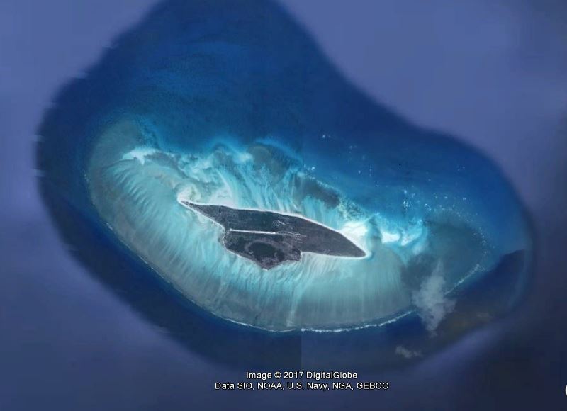
Cruiserswiki.org - (also Saint-Christophe, French: locally Île Juan de Nova or officially Île Juan da Nova) is a 4.4 km² low, flat, tropical island in the narrowest part of the Mozambique Channel, about one-third of the way between Madagascar and Mozambique. Anchorage is possible off the northeast of the island which also has a 1,300-metre-long airstrip.
Administratively, the island is one of the Scattered islands in the Indian Ocean, a district of the French Southern and Antarctic Lands.
Juan de Nova, about six kilometres long and 1.6km at its widest, is a nature reserve surrounded by reefs which enclose an area (not a true lagoon like in an atoll) of roughly 40 km². Forests, mainly of Casuarinaceae, cover about half the island. Large numbers of terns (Sterna fuscata) breed there from November to March. Turtles nest in the beaches around the island.
The island is named after João da Nova, a Galician admiral in the service of Portugal who came across the island in 1501. It has been a French possession since 1897. Guano (phosphate) deposits were exploited from the start of the 20th century until 1970. The island was abandoned during World War II and was visited by German submariners. Installations, including a hangar, rail lines, houses and a jetty are in ruins.
Juan de Nova, with an Exclusive Economic Zone (EEZ) of 61,050 km², is claimed by Madagascar. The island is garrisoned by French troops from Reunion and has a meteorological station (Saint-Christophe).
Juan de Nova, in the sea route between South Africa and the northern tip of Madagascar, is affected by strong currents, and has become the site of numerous wrecks. Most visible are the remains of the SS Tottenham which ran onto the southern fringing reef in 1911.
6.2 Bassas Da India (21 26.70S 039 42.50E)
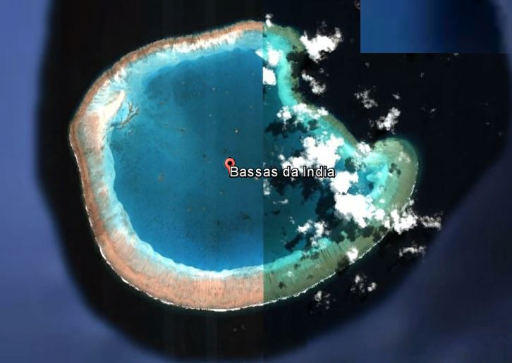
2017 Blue Sky - Anchored here for a SW blow at 21 26.70S 039 42.50E. Good anchorage, good snorkelling. Strong currents.
CruisersWiki.org - The enclosed lagoon is full of coral heads and the small coral atoll at the north end (that covers at high tide) is the most prominant section of the reef and has a very old, large anchor on it. A narrow boat passage leads into the lagoon around 1M south of the northernmost point of the reef. The outer edge of Bassas da India has a very steep drop-off - a diver's paradise.
It is possible to anchor off the easternmost point of the atoll in calm conditions but, be aware that the tide sets at about 1 knot across this side of the reef.
Bassas da India is a small submerged atoll-like reef, located almost in the centre of the Mozambique Channel, situated around 110 km northwest from Île Europa and 385 km west from the eastern coast of Madagascar.
The reef is largely submerged, but at low tide emerges from the water to a height of 1-2 m. In addition there are a few rocks that are usually above water at all times — these being the only emergent parts of this reef-capped seamount that rises steeply from the seabed 3,000 m below. The reef rim averages around 100 m across and completley encloses a shallow lagoon that has a maximum depth of 15 m.
6.3 Europa Island (22°22.0S 40°21.8E)
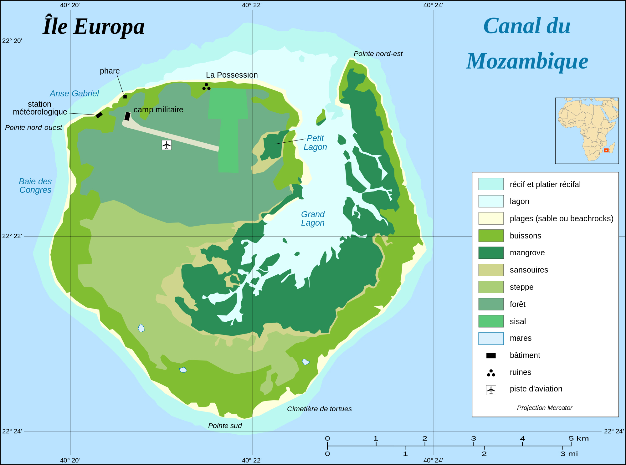
CruisingWiki.org - a 28 km² low-lying tropical island in the Mozambique Channel, about a third of the way from southern Madagascar to southern Mozambique. It has 22.2 kilometres of coastline, but no ports or harbours. Anchorage is possible offshore. The airstrip is 1,500 metres long.
The island is surrounded by coral beaches and a fringing reef and encloses a mangrove lagoon of around 9 km². Its vegetation also consists of dry forest, scrub, euphorbia and the remains of a sisal plantation.
Europa Island is a nature reserve and host to migratory seabirds. It is one of the world's largest nesting sites for green turtles (Chelonia mydas). It is also home to goats introduced by settlers in the late 18th century.
The island takes its name from the British ship Europa, which visited it in 1774. It has been a possession of France since 1897, but is also claimed by Madagascar. Ruins and graves on Europa island attest to several attempts at settlement from the 1860s to the 1920s.
Its Exclusive Economic Zone (EEZ) is contiguous with that of Bassas da India, is 127,300 km². The island, garrisoned by a detachment from Réunion, has a meteorological station and is visited by scientists. Europa though uninhabited is formally part of the "Îles Eparses" district (Scattered Islands) of the TAAF (Terres Australes et Antarctiques Françaises) administrative region.
You are welcome to go ashore to the met station (with passports in hand) on the strict understanding that you cannot be supplied with water, food or medicines.
There is anchorage with shelter from the southerly winds north of the island, off the only visible building ashore (meteoroligical station). Anchor beyond the fringing reef in 5 to 6 meters on sand, among patches of coral. The anchorage is only really comfortable in calm weather
7. TRIP REPORTS
7.1 Ocelot 2007
We jumped off from Bali Bay, Madagascar (16°0'S 45°17'E) at 6am Saturday, November 3, with 2 other boats - Irene, a South African/German couple on a 38' (11.5m) Prout catamaran, and Kyena 2, a 33' (10m) monohull with an Australian/Indonesian couple and their adorable 1.5 year old daughter, all smiles and giggles. Bali Bay is about 50 nautical miles ENE of Cape St. Andre, which forms a nose about 85 nautical miles north of the westernmost point of Madagascar. Bali Bay is about the last decent anchorage along this coast and it's the traditional jumping off point for boats heading SW towards Mozambique and South Africa. The night before we left we all got together on Ocelot (of course) for a big potluck and strategy session.
Our strategy for the 1,000 nautical mile passage to Richards Bay, South Africa, was to head more towards the Mozambique side of the channel, as there we could pick up the beginnings of the swift Agulhas Current that sweeps down southern Africa. This would also let us duck into anchorages along the Mozambique coast if conditions warranted it.
We're no longer really in the trade winds, so we can't depend on the constant ESE winds that have pushed us 70% of the way around the world. The winds in the Mozambique Channel (between Mozambique and Madagascar) have usually been from the south, but like the Pacific, the winds here are determined by weather systems that move from west to east far south of us, down in the "Roaring 40s". A system was coming through that would bring strong winds from the NE, and we hoped to ride those winds down the Channel. The gotcha was that a front was forecast to come up the coast from South Africa, so it would be a bit of a race to see how far we could get down the Mozambique coast before the front smacked us.
Our sail the first day was delightful! We flew the spinnaker much of the day and then the wind moved more off the beam, giving us a fast ride. Since we were still near the coast, we were still in the onshore / offshore (morning / afternoon) winds that predominate along the coast of Madagascar. The wind died about 11pm and we started motor-sailing, which lasted much of the next day. This was expected if not hoped for - winds on the Madagascar side of the channel are often light, and the currents often contrary. We wanted to get out of the contrary currents as soon as possible.
The good news was that the forecast front looked like it would dissipate just a bit north of Maputo, Mozambique, so we could head more directly for Bazaruto Bay at 21°30'S 35°24'E or about 650 nautical miles southwest of where we started. This was a considerable relief as the next closer anchorages were far north of Bazaruto.
The winds eventually filled in from the NE at about 9:30pm, allowing us to shut down the engine. The wind slowly climbed to 25 knots, forcing us to take a reef in the main at 2am, always a bit more exciting than we like. But the strange thing was the current - it built up from 2 knots at 8pm to over 6 knots(!) by the morning of November 5th. The current was flowing basically SE, so it pushed us to the left quite quickly, forcing us to sail further to the west and even northwest to keep on our course. Eventually we were sailing at 290° just to make our course of 245° over the bottom. Crazy! We expected some current on this leg, but nothing like 6 knots. By afternoon the current began slackening slowly and flowing more to the south, allowing us to point more to the west and even a bit southwest.
But the big news happened that morning, Monday November 5th. Jon was on watch at about 6:30am when he suddenly saw, in a wave trough, what appeared to be a huge log floating just in front of us. He quickly disengaged the autopilot and wrenched the wheel hard to the right. Looking up, he recognized the "log" to be the back of a huge sleeping whale. But there wasn't enough time for Ocelot to turn as far as was needed. We came down (gently) on the whale with our port keel and then it dove, whacking us a good one with its tail back by the engine room as it did so.
Checking for damage, we found that 4 hose fittings had broken in the engine room and water was coming in. The engine cooling water fittings were relatively easy to fix and that stopped the water from coming in, but the bilge pump fittings took a bit longer as some parts had to be adapted to fit. After an hour or so the water was pumped out and things were mostly back to normal. We also found that our outer skin of fiberglass was cracked over an area about 1' (30cm) on a side, about 1' (30cm) above the waterline. Our hulls are a sandwich construction - fiberglass, foam-core, fiberglass - but only the outer skin of glass was broken. Luckily, the inside of the hull right there is heavily reinforced, so we still had hull integrity. But we didn't know how much damage we had below the waterline. Our keels are strong and the lowest part of Ocelot, but it's hard to imagine the whale didn't hit the left-side rudder and/or sail-drive (propeller). We'd have to see when we got to Bazaruto.
That night was pretty rough - 30-35 knot winds and building seas - but things calmed down considerably the next day. Both the wind and current eased, allowing us to turn off to a more comfortable point of sail. Ocelot loped along happily wing-and-wing with about 25 knots of wind directly behind us. We tucked 2 reefs in the main to starboard and the full jib out to port and let Otto (the autopilot) do all the hard work.
Unfortunately, we were exactly the wrong distance from Bazaruto. We'd either have to race to get in before dark the next day, or stall and bob around for another night so we could approach the following day. We initially took what we thought was the prudent approach of waiting an extra night, but then we discovered 2 things: We heard that some inclement weather was approaching, and we found that we were finally in the swiftly flowing Agulhas Current and it was adding almost 3 knots to our speed. So we put the pedal to the metal and shook out the reefs, covering over 100 nautical miles in our final 12 hours and averaging about 9 knots, despite weakening winds all day.
Our final challenge was that we arrived at the entrance to Bazaruto Bay at full ebb tide, so this brought the current against us. The outer anchorages would not have been protected with the prevailing easterly winds, so we had to go 9 miles inside the bay, with a 2 knot current against us, to anchor. We arrived about 10 minutes before absolute dark and anchored in 27' (9m) at 21°37'S 35°20'E, behind Santa Carolina (Paradise) Island. Our final passage stats are 689 nautical miles sailed in 4 days 13 hours for an average of 6.3 knots. Long hot showers, a delightful dinner, and a mindless James Bond flick to decompress before we all crashed in wonderful slumber. We didn't even have to hold the beds down to keep them from rocking!
The next morning we dove on Ocelot to see if we had additional damage. The whale's tail appears to have whacked both our prop and our rudder on port side, bending a blade on our (new!) prop and taking a small chunk out of the bottom of the rudder. The propeller is easy to replace - we now carry 5 spares - so we quickly put on one of our folding propellers. The rudder also shouldn't be very difficult as they drop down out of the boat fairly easily. This will allow us to do a proper epoxy fix on dry land.
We'll probably stay in this area for the next few days. Our friends on Irene and Kyena 2, who left the same time we did, arrived 40 hours after us and had to weather a nasty 40 knot southerly squall (which had us scurrying around to the other side of Paradise Island in the middle of the night). We'll probably go do some exploring until our next weather window lets us hop south. We have 2 more potential anchorages on our way to Richards Bay, 500 nautical miles away - Inhambane, 130 nautical miles south of us and Inhaka just offshore of Maputo, 240 nautical miles past that. We may bypass 1 or both if conditions permit.
After our rather harrowing night where we had to weather a vicious squall by moving to the other side of Santa Carolina (Paradise) Island in the dark, and with more bad weather on the way, we decided to seek a more protected anchorage. So we moved to Benguerra (Santo Antonio) Island, just south of Bazaruto Island. Getting there was quite interesting as much of Bazaruto Bay is very shallow, so we left on a rising tide with the sun high so we could see and dodge around shallows and sand-banks. We actually visited 2 anchorages off Benguerra, the first at 21°51.7'S 35°24.9'E where we spent several days exploring, playing on the sand dunes, hiking, birding, shelling, helping the 2 small resorts with their computers, and visiting with a neighboring catamaran. Then we moved up to 21°49'S 35°27'E where we explored the sand dunes in glorious isolation while waiting for a weather window south. Waiting here allowed us to exit Bazaruto Bay between Benguerra and Bazaruto Islands, saving us from the 30 nautical mile trip around the top of Bazaruto Island.
We jumped off from Bazaruto Bay on 14 November and suddenly found we had a strong current pushing us along. It was so strong that we had to take down most of our sail or we'd arrive at Inhambane, 120 nautical miles to the south, in the dark! As it was we arrived just at daybreak, which coincided with high tide so we could scoot across the shallow bar and tuck in behind a long sand-spit at 23°47'S 35°28.5'E. Again we went exploring and birding and meeting some of the locals while a nasty front blew over us from the south. Sue and Amanda hitched a ride into town to get some fruits and veggies and to see some of the local color.
This area of Mozambique has become quite a playground for South Africans, with several resorts and time-shares springing up. This is somewhat surprising as the current rulers of Mozambique are the Frelimo, the terrorist organization that forced the Portuguese to leave in 1974. Apparently, after a period of anarchy, they're now getting down to running the country and people are investing again. The government is even trying to get farmers back by giving them land, so the earlier exodus is reversing.
We jumped off from Inhambane on 19 November, heading either for Inhaca, off the capital of Maputo, or Richards Bay, South Africa. We didn't want to go to Inhaca as the rather corrupt Mozambique officials often prowl around charging yachts whatever they feel like, but there was also yet another front coming up the coast towards Richards Bay. We'd been maintaining twice a day radio contact with a Durban weather expert ever since Madagascar and he thought the front would dissipate before it got to us. So we gladly changed course to head for the coast of South Africa.
Unfortunately, Fred wasn't quite correct and the front gave us about 18 hours of 20 knot head-winds in the middle of our passage, but on the whole it wasn't that bad. We covered about 360 nautical miles at an average speed of 6.5 knots but the GPS says we hit 15.8 knots(!) during the first day, and much of the last day we were scooting along at 8-12 knots. At that, we were lucky we got into Richards Bay when we did because the other 6 boats coming south all got hammered by a completely unforecast 35 knot southerly squall. We had to make an 8:30pm night entry, always a bit nerve-wracking but we knew our electronic charts for this area were spot-on.
So we're now cleared in and tied to a concrete wall as there is essentially no room at either of the marinas. In the next few days we'll look into hauling Ocelot out to repair the whale damage and paint the bottom. In the meantime we're meeting old (and new) friends. November 22nd is our Thanksgiving in the US and we'll be celebrating it here as well, but on the 23rd as we need time to put the feast together. It looks like it will be a 10 person joint effort hosted on Ocelot (of course).
2017 Alba (Madagascar to Bazaruto)
Day 1: The alarm went off at 03:00 and after downloading the latest GRIB files, we were soon pulling up the anchor. “Red Herring”, “Moana” and “Luna Blu” were already 10 miles ahead of us as we motored out of the Bay with hardly any wind. Out at sea, we found ourselves beating into a 5-10 knot wind from the south-west. The sea was surprisingly choppy, making it difficult to sail with the waves stopping us regularly - we turned the engine on several times during the next few hours.
At 09:30, the sea-breeze finally arrived giving us 8-12 knot winds from the North-east, so I poled out the genoa to starboard. By noon, the wind had backed to the North and dropped to 5-10 knots, so we dragged out our asymmetrical spinnaker, which added a knot or two to our boat speed. We had blue skies all day, so it was lovely sailing.
The wind gradually backed more, moving forward of the beam and slowly increasing to 12 knots, so mid afternoon, we dropped the spinnaker and pulled out the genoa again. The remorseless rotation of the wind continued and by sunset, the wind was back to SW - dead on the nose, so we were forced to sail more and more south.
At the start of my 7-10 watch, we were on a course of 200° - a long way from our desired course of 245°, so anticipating the wind to continue backing, I tacked onto a course of 310°. By 01:00, it increased to 20 knots from the SSW, so we were back on course again with one reef in the mainsail, beating upwind at over 6 knots. The seas were fairly flat, with 1 metre waves and we had a full moon with scattered clouds so it was pleasant enough. Unfortunately, we had a current of 1 to 2.5 knots against us which slowed us down a lot.
It was a hectic 24 hours, using all of our sails on all points of wind. Let’s hope that the wind speed and direction stays more consistent for the rest of the passage and that we can find more favourable currents.
Day 2: Our position at 07:00 was 16:27S 043:12E. The wind gradually dropped, so at dawn Glenys turned on the engine. The others in our little fleet have encountered the same counter currents, but “Red Herring”, who are 25 miles ahead of us, said that the current seems to be slackening off as they are approaching Ile Juan de Nova. We have our fingers crossed – it’s a little depressing to be motor-sailing at 6 knots and only doing 3.5 knots over the ground.
After breakfast, I downloaded new Grib files and plugged them into qtVlm. It generated a route that passes to the north of Ile Juan de Nova and then heads roughly south-west. The RTOFS grib file shows a 150 mile diameter, anti-clockwise rotating current centred around 19°06S 39°10E. This current is up to 3 knots, so the routing algorithm is taking us around the top and down the west side of this “eddy”. Hopefully, we’ll be in a favourable current tomorrow.
We were 20 miles short of our planned target yesterday and only did 117 miles in 24 hours. We will have to exceed our projections to get to Maputo before the strong southerlies on the 9th. This seems to be very unlikely, so I’ve changed our planned destination to Inhambane. We have 665 miles to go and qtVlm is forecasting an arrival on the afternoon of Sunday 8th – the southerlies arrive at Inhambane on the morning of the 9th.
Other than that, the grib files showed E/NE 8-10 knots today and then lighter NE/N/NW winds tonight. It looked like we’d be doing a lot of motoring, so I checked our fuel - we have about 390 litres of diesel in our fuel tank and 63 litres in jerry cans. Our average fuel consumption is 2.5 litres per hour, so we’ve enough fuel to motor for 182 hours, which is 7 days, so I’m not worrying yet.
Mid-morning, the wind picked up to NE 10-15, so I poled the genoa out to starboard and we were able to roll along at 5.5 to 7 knots, albeit still with a 1.0 knot current against us. We had a great sail for the rest of the day, with blue skies. After sunset, the wind backed to the NW and dropped to 5-10 knots. We slowly sailed at 4 knots for a while, but we still had 1-2 knots of current against us, so I cracked up at 20:00 and started the engine.
By midnight, we had variable wind (less than 5 knots) and a current against us between 1.5 and 3 knots. We’re heading on a course of 250° to try to get west and find the elusive Mozambique current.
I’ve been using the RTOFS current data, which so far, has not compared well to the actual conditions encountered. I downloaded a Grib file containing OSCAR Current data and the currents are very different to RTOFS. For example, at our present position (17°23S 42°00E), the RTOFS file says that we should have 1.2 knots setting North and the OSCAR file says that we should have 1.2 knots setting South – in reality, we are heading West and have 2 knots against us. It’s three o’clock in the morning and I feel like screaming in frustration.
If the current data is unreliable, then the routing produced by qtVlm is also unreliable, which is a problem. As an experiment, I produced three routings in qtVlm – no Current data, RTOFS Current data and OSCAR Current data. Without any Current data then the routing is a rhumb line – not very helpful. Interestingly, despite the differences in the data, the two routings produced using RTOFS and OSCAR data follow roughly similar paths, crossing over each other with a maximum difference of 20 miles.
When I plot a route that averages out the OSCAR and the RTOFS routes, then I get a route that roughly follows the 2000 metre depth contour about 100 miles off the Mozambique coast. This seems like a logical thing for a ocean current to do, so I’m going for that.
In retrospect, I think that we should have headed straight west until I picked up the Mozambique Current, which is what Des Cason originally recommended. I thought that using the Current data would enable me to “cut the corner” and give me a more efficient route. Sometimes traditional experience is better than new technology.
Day 3: Our position at 07:00 was 17:30S 041:36E. Dawn brought us a nice ENE 10-15 knot wind, so Glenys was able to turn the engine off and sail on a broad reach. Even better, was that after motoring for nine hours, the damn counter-current finally disappeared.
When I woke up at 07:00, I downloaded new Grib files and plugged them into qtVlm. I created two routings to Inhambane – one based on RTOFS and one based on OSCAR Current data. I imported these routes into my OpenCPN chart plotter and then created a route that was an average of the two. It was more or less the same as the one that I created in the small hours of last night, so I’m using the new route for the next 24 hours and we laid a course of 250°T. At 07:00, we had 524 miles to go, but in the last 24 hours, we had only done 115 miles over the ground, which is a pathetic 4.8 knots.
Strong south winds are still forecast to arrive in Inhambane at 01:00 on Tuesday 10th, so we want to arrive there at 12:00 on Monday 9th, which will give us a 12 hour safety margin in case the front arrives early. We have 4 days to get there. This is an average of 5.2 knots or 125 miles per day, which should be easily achievable, provide that we do not encounter any more unfavourable currents. I’ll be keeping a keen eye on our progress.
During the morning, the wind gradually backed to NE 10-15, which allowed us to pole the genoa out to starboard on a broad reach. It was a glorious blue-sky day and we bowled along at 5.5 – 6.5 knots with no noticeable current.
As usual, we’ve soon dropped into the routine of a long passage – we do three hour watches from 19:00 at night; breakfast at 08:00; Glenys goes to bed for a couple of hours in the morning; I have a two hour kip in the afternoon; dinner is 20 minutes before sunset; we both have a shower and then I take the first night watch at 19:00, while Glenys goes to bed. It’s like Groundhog Day.
The wind started to drop in the late afternoon and at sunset we started to motor - we had less than 5 knots of wind all night. At the change of watch at 01:00, we encountered another slight counter-current of about half a knot. This was really frustrating because I knew that the Mozambique Current was somewhere to the west of our position - we’d chatted to Wairima yesterday on the SSB and they had 2 knots of good current on their track 35 miles west of us.
I did a little experiment to see the effect of our heading on the speed over the ground and I was surprised to find that a 20° change in heading caused a 0.4 knot change in speed over the ground (7.5%). Our speed through the water was 5.9 knots.
Heading COG SOG
255°T 270°T 5.8 knots
235°T 248°T 5.4 knots
215°T 226°T 5.0 knots
I wondered whether it would be better to cross the adverse current rather than fighting it? I grabbed a piece of paper and did some basic trigonometric calculations. Wairima’s track in the south-setting current was roughly 225°T, so if we continued to head on a course of 248°T then it would be 70 miles until we crossed their track. If we headed west, then we would cross their track in only 35 miles.
The extra distance doing this dog-leg track would be only 6 miles, but if we picked up the 2 knot current sooner, then I calculated that we would take 11.4 hours instead of 13.1 hours to reach the same waypoint. I altered course to take us straight west - it felt much better to have a faster speed over the ground.
Day 4: Our position at 07:00 was 18:22S 039:25E. The wind picked up at dawn again, so Glenys was able to get us sailing on a port broad reach. Last night’s cunning plan didn’t go as well as I expected – we had a favourable current this morning, but it was only 0.5-1.0 knot rather than the 2 knots that we were expecting. Still, mustn’t grumble.
Interestingly, at 08:00, we had small “puff ball” cumulus clouds, which are caused by the convection rising from the warmer south-flowing current, but by 10:00 we were back to solid blue skies. We’re only 6 miles east of the position where “Wairima” reported 2 knot currents, but we can’t find these elusive strong currents.
The weather forecast this morning shows that the strong southerlies, which were expected to arrive in Inhambane at 01:00 on Tuesday 10th (Monday night) are not going to arrive until 18:00 on Tuesday 10th. This gives us an opportunity to try to get to Maputo, which is 210 miles further down the coast. To achieve this we’re going to have to average 6 knots over the next 4 days, which is achievable if we continue to get favourable currents.
Mid-way through the morning, the wind backed, going more behind us and reduced in strength, so I poled the genoa out to port. This worked for a couple of hours, but the wind dropped even more to 5-8 knots, so we dragged out the spinnaker, but even with the main sail and the spinnaker, our boat speed dropped to 3-4 knots. We took advantage of the calm conditions to run our water maker.
While we were bobbing along, a huge pod of dolphins joined us to swim in our bow wave. It wasn’t terribly exciting for them because we were drifting along at only 4 knots, so they entertained themselves by making huge leaps out of the water, spinning 2 or 3 times. Unfortunately, they did this at random times and places, so I have many photos of huge splashes, but none of dolphins spinning majestically in the air.
At 15:00, our water tanks were full and we needed to get a move on, so we dropped the spinnaker and turned on the engine. In these calm conditions, our boat speed was 5.7 knots at 1700 rpm and we were doing 6.7 knots over the ground. Maputo here we come...
Glenys produced a Zebu Curry and rice for dinner and we watched another lovely sunset, by which time, the wind had picked up to SE 10. We pulled out the sails and set off on a close reach, which in these calm seas, gave us a boat speed of 5.4 knots. The current has picked up to 1.5 to 2 knots so we were doing 7.0 knots over the ground - I’m so glad that we’ve found the current.
With nothing else better to do on my night watch, I did a little analysis of our performance compared to “Wairima”, which is a similar sized monohull.
Alan and Vicky took the “classic” route by heading west until they found the Mozambique Current at about 16°15S 41°10E and then followed the current along the coast. They had 1 knot of against them for 130 miles from the drop off at Cap St Andre across the Mozambique Channel, but after that had 1 to 2 knots of current with them.
We “cut the corner” trying to go a shorter distance and use the Current data in grib files to make the best use of the currents. This strategy didn’t work very well because we had adverse currents of between 0.5 to 3 knots for 250 miles from the drop off at Cap St Andre. Our route was only 20 miles shorter than “Wairima’s”.
“Wairima” left Baly Bay 24 hours ahead of us, but at 0800 this morning, they were 250 miles ahead of us. Assume that for the last 24 hours, they have done 6.5 knots average with the current, then they have gained 94 miles in 3 days (and shortened their passage by 14 hours.) If I ever do this passage again, I will definitely be heading west until I find the current.
After a beautiful sunset, the first half of the night was idyllic, sailing in flat seas with a full moon, clocking speeds of up to 8 knots over the ground. After midnight, the wind increased slightly to ESE 15, so we were screaming along at 9 knots. In the 12 hours up to dawn, we covered 95 miles, which is an average of 7.9 knots over the ground – probably one of the best overnight sails we’ve had in ten years of cruising.
Unfortunately, just after dawn, the wind suddenly dropped to 6 knots and backed to the East, so we had to turn on the engine.
Day 5: Our position at 07:00 was 20:29S 037:28E. With very light winds, we spent the morning motoring south, achieving 6.5 knots over the ground.
Today’s weather forecast shows that gale-force southerly winds are expected in Maputo on the 10th at 15:00 - a few hours earlier than forecast yesterday and the low pressure system causing the southerlies has also deepened bringing stronger winds.
Des Cason has been sending me an email every day and today he said, "The small cut-off low which would have brought light SE to Inhambane/Maputo on the 10th has intensified. A high pressure has ridged in behind it bringing some pretty hectic SW/S winds along the coast. 40+ knot winds are expected off Richards Bay on the 10th. This will spread up the coast to Bazaruto and persist up to the 13th at least in the 25kts range. At 21:00 on the 10th, the low will be at 30S 37E, 1007 Mba with SSW/S 40kts at the epicenter. By the 11th it has moved to 29S 42E, 1003mba, SSW/S 30 kts."
Our plan was to head for Maputo and then dive into Inhambane if we thought that we weren’t going to make it before the front. However, Des has warned us that after a few days of NE winds, the outside anchorage at Barra Point, Inhambane will “not be fun with 1.5 to 2 metre swell”. The inner anchorage at Linga Linga doesn’t sound good either because there’s a shallow 0.4m sand bar at the entrance, which means that we can only enter and leave at 2 hours before high tide, which is very restricting.
So, we had two options:
1. Head for Maputo, which at 07:00 this morning was 430 miles away. If we give ourselves an 8 hour safety margin and aim to get to Maputo at 07:00 on the 10th, then for the next 3 days, we will still have to average 6.0 knots (143 miles per day). We have averaged 150 miles per day for the last two days and the last 24 hours was 168 miles. If we retain the favourable current and have good winds, then we should make it.
2. Head for Bazaruto, which is 115 miles away. We could be there tomorrow morning without any problem. We then hide there, leaving after the system goes away, probably on the 13th.
The risks of heading for Maputo are that we may lose the favourable current and the low pressure system may develop faster. If we have light winds, we’ll have to motor hard for up to 3 days and if the engine has a problem, we’re doomed. If something doesn’t go as planned, then we will be trapped at sea in a serious storm (up to 40 knot winds and 6 metre waves) for several days.
The only disadvantage with going to Bazaruto is that we’ll be delayed getting into Richard’s Bay by at least a week, but we’re in no hurry – our son isn’t coming out to visit until the 17th October, so we have plenty of time.
So, we either have three days of stress, racing to beat a big storm or we chill out in a secure anchorage for five days with some other cruisers. It was a no-brainer - at midday, we turned west towards Bazaruto.
I chatted to “Red Herring” on the SSB radio and they have also turned back to Bazaruto. “Luna Blu”, “Continuum”, and “Moana” are already on their way. “Wairima” are now south of Inhambane, so they will make it to Richards Bay. My only concern is that we might not have enough beer.
We had a very relaxing afternoon, sailing along at 3-4 knots in the light north winds, which carried on into the night. After midnight, with only 40 miles to go, the wind picked up to NE15, so Glenys rolled away the main and we ran on a reefed genoa at 3 knots until dawn. Unfortunately, we had confused, sharp 1.5 metre waves, which made us rock and roll all night.
We encountered some strong currents in this area, which would suddenly change direction and alter our course through the water by 20 degrees. There were also noticeable changes in the sea state as we went from wind-with-current to wind-against-current. I guess that these are eddies being generated at the edge of the continental shelf.
Day 6: Our position at 07:00 was 19:43S 061:27E. At dawn, we had light north winds, so we were only able to sail at 3-4 knots. This was okay because we wanted to wait until midday, when it was low tide and the best time to start to negotiate the channel through the sand bars. Unfortunately, the sea was still very confused, making us bounce around unpleasantly for six hours.
We had a bit of confusion with time zones. Our Ship’s Time was UTC +3 with all our clocks set to Madagascar time. Our normal source of tides is the Navionics Chart app on our Samsung tablet. It told us that low tide was at 12:00, but indicated that the tide was in the “Central Africa” time zone, but what was that? Was the low tide really at 11:00, 12:00 or 13:00 in Madagascar time? The last thing that we want to do after five nights of sleep deprivation is wrap our heads around the conundrum of time.
Fortunately, technology came to our aid. We configured our tablet to automatically set the local time zone and it used it’s GPS position to work out that we were now in the Central Africa time zone (UTC +2) - an hour earlier than all our other clocks. Phew! So low tide was actually at 13:00 (Ship’s Time). To avoid any more confusion, we turned all our clocks back one hour, so Ship’s Time is now UTC +2 and low tide is now at 12:00. (I think!)
We started our approach into the channel at 11:00 (UTC+2), following a set of waypoints published by Des Cason. They were spot on, but we were eye-balling the water depth all the time, using the colour of the water. There are many sand banks along the 12 mile route, but the water is clear and the lighter colour of the shallow spots is easy to see. We had to do a bit of a dog-leg around one shallow sand spit - 21°35.711S 035°24.441E and 21°35.930S 035°24.819E gets you around it.
All the way points are: 21°30 00E 35°25 00S; 21°32.50E 35°23.40S; 21°35.50E 35°22.40S; 21°35.90E 35°24.10S; 21°35.711S 035°24.441E; 21°35.930S 035°24.819E; 21°38.77S 035°25.60E.
“Red Herring” and “Luna Blu” came in with us and there was much debate about where to anchor because the normal anchorage north of Ponta Gengare was very gnarly in the NNE15 winds, which had picked up as we came in through the channel. Eventually, we all headed to the south of the point and anchored at 21°40.39S 035°25.87E in 12 metres, which was much more sheltered.
Once settled to anchor, we had a shower, an afternoon nap; a few cold ones; dinner and early to bed.
Today’s weather forecast shows that the low pressure system is not going to produce very high winds, but the south winds are hanging around the coast for longer (until the 15th.) This means that we won’t be able to start heading south for a week - at least our time here in Bazaruto will be pleasant without any storm force winds. Of course, that could all change tomorrow.
7.3 Alba 2017 (Madagascar to Bazaruto)
Day 1: At dawn, the wind was 10-15 knots and then slowly backed to the NE. We spent the morning tidying up, running the watermaker and getting ready for sea. There wasn’t much to do, so we were ready to go by 11:00 and then had to wait for the tide, so that we could get over the sand bar in the pass.
We were planning to leave two hours before high water at 14:00. This would ensure that we had an incoming tide which would flatten the incoming swell from the east. The worst time would be to try to leave in an out-going tide, which would mean that the current was against the swell and would cause steep “overfall” waves. The other factor in our timing was that, just before high tide, the tidal current would be less and we would have more water over the bar.
“Luna Blu”, “Continuum” and “Fortuna” cracked up early and left the anchorage at 12:00. The least depth that they saw was 5 metres and the sea was fairly calm, but they had to battle against a strong current over 3 knots. “Fortuna” have an engine problem and can only run at low revs, so they were only making 1.5 knots over the ground.
We were good little bears and stuck to the plan, pulling up our anchor at 14:00 together with “Red Herring” and “Mowana”. There was still a strong 3 knot current against us in the narrowest part of the channel between the two islands and the water was very turbulent, pushing us around. However, it calmed down to 0.5 to 1 knot after that and we made good progress - the waves also settled down to a smooth 1 metre swell.
Our route went along a channel to the south of the shallowest sand bar - the lowest spots were 6.5 metres (2.5m LAT) in a few places after 21°48.10S 35°29.05E. (Our way points were:21°48.23S 35°27.55E; 21°48.05S 35°28.09E; 21°48.10S 35°29.05E; 21°47.56S 35°30.21E; 21°48.06 35°31.02E.)
Once clear of the bar and in deeper water, we turned SSE and reached away from the reefs. There was a smooth 1-2 metre swell from the east; east 10-15 knot winds; and we had current with us, so we made good progress doing 6.5-7.5 knots over the ground up to midnight.
On our 19:00 SSB radio net, Luna Blu was 13 miles ahead of us, with the rest scattered about, going in slightly different directions trying to find the best current. Our strategy was to slowly creep away from the shore to a point 15 miles off Barra Falsa and then maintain that distance off shore. It seems to be a reasonable plan because we had at least 2 knots with us at midnight.
“Jackster” came up on the radio – they left Madagascar four days ago and are only 70 miles behind us, so they’ve had a good passage. They are 53 foot long (10 foot more than us), so they are much quicker and, despite the fact that they left Madagascar 10 days after us, they will probably beat us to Richards Bay...
We encountered several trawlers on our route, moving at 3 knots in surprisingly deep water (>300 metres). They were well lit, had AIS and a very consistent course, so they were easy enough to dodge.
At our 01:00 watch change, we altered course more south, which put the wind at 50 degrees to our port aft quarter, so we gybed the genoa and poled it out to port. Unfortunately, an hour later, the wind dropped and we were only doing 1-2 knots of boat speed, so I turned on the engine and we motored for the rest of the night.
Day 2: As the sun came up, the wind picked up to E 10-15, so Glenys dragged out the sails. Again, it only lasted a few hours before the wind died again. The weather forecast shows light winds until tomorrow, but there’s a chance of sailing later today providing that the wind veers to the ESE (in front of the beam) as forecast.
There are at least nine boats heading for Richards Bay all expecting to arrive about the same time, so it’s going to be chaos in the port. There’s very little space in the two marinas in Richards Bay and they refuse to take advance bookings, so it’s first come, first served. To add to the problem, the marina at Durban, which is only 80 miles away, sustained damage in a big storm 10 days ago and cannot accommodate any visitors at the moment.
It maybe that we can’t get a marina berth at either port, so we might be stuck on a concrete visitor’s wall in Richards Bay. Normally this wouldn’t be a problem to us, but we have our son Craig coming out for a holiday starting on the 18th November and we want to be sure that we have a confirmed, safe berth, so that we can go land travelling with him for a week.
To add to the complex planning, we want to haul-out to replace the cutlass bearing. One solution is that we haul-out for 5 or 6 weeks, so I’ve been trying to arrange something by email, but it’s slow going with their reluctance to commit to dates. I sent off another load of emails this morning to the boatyards in Richards Bay and Durban, so hopefully, I’ll get a reply today. Today is Friday, so if I can’t resolve it today, I’ll probably have to wait until after the weekend (when we’ve arrived) to sort it out. It’s so frustrating.
We continued motoring until 13:00, when the wind picked up to 8 knots, which was enough to fly the spinnaker. It was a nice afternoon of sailing. The wind gradually increased to 12-15 knots and at 17:00, we pulled down the spinnaker and switched back to the genoa. By dark, we had E 18-22 knots and were romping along at 6 knots on a port broad reach with a reef in the main; a reef in the genoa; and at least a knot of current with us.
The strong winds lasted for a few hours and then slowly dropped. At midnight, we were back to motoring for a couple of hours; and then we had 10-12 knots from the east; and then the wind backed, forcing us south; and then a trawler was passing by just when I wanted to gybe; and then after I gybed the main, the wind veered, forcing us further north... It’s tiring stuff this sailing lark.
Day 3: A couple of hours after dawn, the wind died and Glenys turned on the engine. At 07:00, we were halfway with 250 miles to go. If we average 5.2 knots, then we will arrive at Richards Bay at 07:00 on Monday 23rd.
I downloaded two GRIB forecasts – at 1 degree and 2.5 degree resolutions. Worryingly, the low resolution forecast showed pleasant, light 10 knot ESE winds for the day, whereas the high resolution one showed strong S 20-25 knot winds 50 miles ahead of us. There was a very defined north-south line between the strong southerlies and the lighter north-easterlies.
Des Cason sent me an email saying “If you go west of 34E you will cross a shear line between two systems – the southerly component on the coast and the outer west edge of the high pressure south of Madagascar generating the NE/E conditions. By 1800UTC, it’s back to SE10.” We changed from our south-west course and headed south down the 34°50E longitude line.
The other worrying change on the weather forecast is that the next strong southerly will now hit Richards Bay at midnight on Monday 23rd instead of the morning of Wednesday 25th. Our current ETA is 07:00 on Monday, so we now only have a 18 hour safety window to get to Richards Bay – the race is on.
I had another flurry of emails about berthing and haul-out - it’s great having email via our satellite phone. I contacted Jenny Crickmore-Thompson, who is the Durban representative of the Ocean Cruising Club (OCC). We’re planning to become members of the OCC when we get to South Africa and, despite us not being members yet, Jenny has taken up the gauntlet and contacted the various people at Durban marina and boatyard.
The admin office at Durban marina contacted us and offered us a berth in their marina from Monday. Unfortunately, Durban is 80 miles further than Richards Bay and the strong southerly winds are due to get there only three hours before we could make it, which is too tight for me. Perhaps we’ll spend a week in Richards Bay and then head down to Durban to haul-out and be on the hard when Craig arrives from the UK.
We continued motoring south with zero wind until 14:00, when I cracked up and changed course to south-west heading directly for Richards Bay. The nil wind conditions continued for a couple of hours and then, within the space of 10 minutes, the wind increased to 15 knots from the south. We put a couple of reefs in the main and sailed hard on port tack heading WSW rather than SW, but at least we were sailing again.
The wind was fluky for the next 3 hours, varying in speed and direction. We had steep 2-3 metre waves from the south, so in the lulls, we were being stopped dead by the waves. It was frustrating – I had to turn engine on a few times because I didn’t want to keep reefing and un-reefing the sails.
Eventually, by 19:00, the wind settled down to SE 15, so with all the sails out and a single reef in the main, we were able to sail along at 5-6 knots with enough power to get through the waves. Our route took us along the 1000 metre contour towards Jesser Point and, at 26°31S 34°15E, we had 2.5-3 knots of current with us.
On our radio net at 19:00, everyone gave their positions and our little fleet is spread out over 100 miles. Alba is roughly in the middle, with the faster boats 40 miles ahead of us. Some of the boats that are ahead of us crossed the 34°E shear line early this morning and had tougher conditions with 20-25 knot south winds all day, so I’m glad we headed south this morning.
However, the weather wasn’t going to let us off lightly and a persistent drizzly rain set in. The wind picked up to 20-25 knots from the SE for a couple of hours putting us on a very bouncy close reach. I had to reef a few times, ending up with 2½ reefs in the main and just the staysail. Even with that small sail area, we were cracking along at 6.5-7 knots , which combined with the strong current was 9.5-10 knots over the ground.
On Glenys’ 10-1 watch, we passed through some kind of localised weather system. The wind backed and died off to 8 knots from the north-east and it rained. Despite changing the sail plan to wing on wing, the wind and sea was so confused that she had to run the engine for an hour before it settled down to SE12-15. The seas calmed down, so the remainder of the night was pleasant, but very dark with no moon.
Day 4: Dawn brought us 100% cloud cover; SE 10-15 winds and more than 1.5 knots of current with us. At 07:00, we had 120 miles to go, so there was no way that we would make it to Richards Bay before sunset. If we average 5.5 knots then we’ll arrive at dawn tomorrow. Once again, we’re having to slow down to arrive in daylight.
Entering the main port of Richards Bay at night is not a problem, but visiting yachts have to go alongside a concrete wall next to the Tuzi Gazi small boat marina and it looks like a tight place to manoeuvre. Some of the bigger, faster boats will get in about 21:00, which will okay as long as there’s someone around to help find a berth and tie up, but I don’t fancy attempting it in the pitch black after midnight.
The weather forecast is for the SE winds to back to the NE and increase to 20-25 knots overnight. This won’t be too bad because the wind will be directly behind us. However, with the Agulhas current pushing us south, we might struggle to slow down tonight, so we dropped the main sail and spent the morning bobbing along at 3-3.5 knots through the water (still 5 knots over the ground).
It was a very pleasant morning, the sun came out and the motion was comfortable. We even had a pod of dolphins pass by. It was a huge group and they were in hunting mode, leaping out of the water as they pursued their prey at high speed. They didn’t bother to come and play in our bow wave.
At midday, we were surprised to hear an announcement on VHF 16 for a weather broadcast from Capetown Radio. There are repeater stations all the way along the South African coast and we picked up the weather transmission on VHF 03 (other channels in the area are 01, 24 &25). We were 20 miles from the coast and it’s nice to know that we’re now within radio range of the authorities. Just after lunch, Glenys spotted land and we turned south, with only 80 miles of coastal sailing remaining to Richards Bay.
The wind slowly picked up during the afternoon and, by 16:00, we had NE 25-30 knots and 3 metre seas throwing us around. Our sail plan had been reduced to a tiny 3 sq.m. of genoa, but we were still doing 7 knots over the ground, pushed along by a 3 knot current. Fortunately, the wind dropped to 20-25 knots at sunset, so we were able to slow down a little bit.
Our friends on ”Jackster” had been gradually catching us up and, when they were within 20 miles, I was able to have a chat with them on the VHF. Jacqui had the GPS coordinates of an anchorage that “Yolo” reported (at 28°48.2S 32°04.7E, 8m deep), which is just next to the main channel inside the port. “Jackster’s” plan was to sail comfortably and anchor at this spot if they arrive at night.
I had not seen this anchorage when researching into Richards Bay and was uncertain whether the Port Control would allow visitors to anchor there, so I fired off an email to various cruising friends. Des Cason came back and said that the Port Control don’t care where you go once you have entered the port. Tom from “Adina” replied with GPS coordinates and depths, suggesting that we anchor a hundred metres further north than “ Yolo’s” position to keep further from the main shipping channel.
Glenys and I discussed this additional information and decided that we might as well sail at a comfortable speed and if we arrive at night we enter the port and anchor. We let out all of our genoa, our boat speed picked up to 5 knots and the boat’s motion became much more stable. I wish that I’d done my research a little better because we’ve wasted our time fighting to slow down all day.
By 21:00, the wind had dropped to N 15-20 and the motion was pleasant, apart from the occasional monster roll when a wave caught our stern. With a speed over the ground of 8 knots and only 40 miles to go, we’d be there in 5 hours. The sail just got better and better, the seas calmed down and we made good time, approaching the outer port limit at 01:30.
Before I could call the Port Control, they must have spotted our AIS because they contacted us and asked our intentions. They took basic details port of registration, number of people on board, etc and then gave us clearance after one huge tanker exited and another smaller boat entered. It’s a very busy port specialising in coal and there were a score of ships at anchor waiting their turn to pick up cargo.
On AIS, Glenys watched “Nathape” go into the Small Boat Harbour, so she called them up. They said that the harbour was brightly lit and there was a space for us on the concrete Visitor's Dock. The wind had dropped and it was very calm in the main port channel, so we went past the anchorage and directly into the Small Boat Harbour, where we managed to dock in front of “Red Herring” without any dramas.
We collapsed into bed at 03:00. We’re in South Africa…
7.4 Adina 2015
Day Zero. We’ve been monitoring the weather over the past few weeks as Adina tracked south down the west coast of Madagascar, watching for a suitable crossing to South Africa. The challenge is we couldn’t leave too early as we only get a three month visa and didn’t want to risk thwarting New Year’s Eve plans in Cape Town!
We thought we had a window yesterday and made a dash for it around midnight. Alas the forecast was wrong and after a period of bashing through seas hoping it would improve, we decided we’d had enough of salt water being thrown over us, chucked in the towel and headed back to console ourselves. It’s never easy turning back and required some soul-searching but the sea needs to be respected, there will be another day and there is no point in needlessly breaking the boat.
Our eventual target is Richards Bay on the north-east coast of South Africa.
It’s a tricky passage that needs to be well planned and as we’re learning you need a bit of good old luck on your side too. Without getting too technical, big low pressure systems regularly come bowling around the south of South Africa heading north and bringing associated strong winds. These are southerly winds, not what we want when heading south as they’d be right on the nose. They can be nasty and hence sailors like to call them “southerly busters”. Heading the opposite direction to these winds is the strong flowing Agulhas Current. Winds from the south and current from the north is not a marriage made in heaven and all hell breaks loose out at sea.
So, we have been patiently wait for a break, looking for winds from the north or east. Life is still a little complicated as these breaks rarely last long enough to get to South Africa in one hit. So one of the favored strategies is to sail west across to the Mozambique coast and then head south. If a southerly buster comes up seeking a fight with the Agulhas Current there are a few places you can run for cover along the Mozambique coast. It’s this tactic we hope to deploy if we need to.
Days 1&2. Adina left the big red island of Madagascar at 0520 local time on Friday 7th October. It was our second attempt forty-eight hours after having returned a bit shell-shocked from a bashing on the first attempt. Understandably we were a little nervous but the weather forecast this time looked more promising. As we left we soon realised the forecast was wrong yet again, this time happily in our favour. With winds due to be nothing from behind we had expected to motor out, instead we found ourselves sailing upwind in fair winds and we could immediately sail due west as planned. The strategy we are using is to cross to the Mozambique side of the channel and then head south using more favourable winds and most importantly favourable current down that coast. It also means when a southerly buster comes up, which it inevitably will, you can take refuge in a few hideaways on the Mozambique coast.
The waters off Cap Andre where we departed from are shallow, ten to thirty metres, for a long way out. This creates a somewhat bouncy to rough sea state depending on the wind strength. You want to get away from these as fast as possible. But the winds moved north-west leaving us steering south and sailing over the shoals all day long, trapped.
These are good waters for fishing trawlers and we had to play dodgems trying to stay well clear of their vast nets that hang out the back. And if you can’t beat them, well, join them. Finally Susie granted permission for fishing lines to be deployed. The freezer has been well stocked this year and we have a nice record of catching fish on every long passage between countries this year.
A while later the lure was spinning away madly – but it was odd, it looked like a 1L plastic milk bottle was caught on it. Saddened it wasn’t a fish we hauled it in – but it was a fish and a shark had bitten off its tail and the poor thing was spinning round! Strike 1 – a nice wahoo. Or yaa-heee as our friends Charlie and Nicola in London call them.
As it got dark the winds died and we could finally motor out of the shoals and head due west. On the way down the Mozambique coast are three possible stops. The first Bazaruto, apparently a beautiful spot full of islands and sandbanks. The next stop is Linga Linga at Inhambane and the third stop Maputo before you head south to Richards Bay in South Africa. You use these stops as shelter points if a strong south wind comes up. If we average 6 knots of speed over the ground we should make Linga Linga before the next southerly buster comes up. But sailing downwind and with a lot of light winds forecast in parts it’s proving to be a challenge to achieve. And you need to pray that southerly doesn’t come up early. Day 1, Friday 7th, we averaged 5.5 knots.
Saturday dawned and we were motoring. Light winds were forecast and we opted to motorsail – that means using the sails to harness what wind there is and the engine also to propel us forward. We know it’s a push to get to Inhambane and we agreed we have to work hard on sail changes, trimming etc. to maximise our speed. It wasn’t long before the spinnaker pole was being used to keep the big genoa pinned out to try to catch more wind. And then the wind changed and we swapped it all over again.
While our fishing record remains proudly intact, it seemed wrong not to have another go. Susie had just woken when she was asked to help administer some alcohol to a small yellowfin tuna’s gills. Our technique is to haul the fish in, quickly place a towel over its eyes to calm it and wish it away with a tot of some spirit. Works a treat and worry not that particular spirit is better used on a fish than drunk. Strike 2 – Yellowfin tuna is Susie’s favourite fish and a real treat.
Our first two days on passage we always take it easy trying to find our sea legs. That meant reading and playing our favourite Monopoly Deal card game. The fishing lines still out while we played, we hooked a mahi – that would complete the trio of deep water fish! It was a sizeable male bull and pretty mad. Mahi, otherwise known as dorado or dolphin fish, are big green/blue fish with yellow fins and bulging heads. And they fight – you always know when you’ve hooked one as they dash from side to side, spin around madly to try and free themselves. This one was an expert and while we played it in the water, as we pulled it out, it’s final furious spinning and thrashing madly got it off the hook. No doubt off to tell his friends to stay well clear of anything pink in colour as they have nasty hooks. A shame to lose it.
Late afternoon the winds picked up but alas we had adverse current against us. Into the night we sailed as best we could and when the wind blew we did well. But it didn’t last and we sailed on with light winds constantly adjusting the sails. All-in-all it had been a good day and by dawn of Sunday we were close enough to the Mozambique coast to head south and hopefully well positioned to find good current. Winds are variable today but due to increase to quite breezy tonight.
End of day 2 and the average speed over ground is up to 5.8 knots, a reward for our work but still short of our 6 knot target. It’s an anxious game this one.
Day 3. We know we have to push hard to get to Inhambane on the Mozambique coast, our first planned shelter point en route to South Africa, by Wednesday evening when southerly winds are forecast. That means we have to work Adina as hard as we can. With the winds slowly picking up but not yet enough to reach our target speed with white sails we decided at 6am to get the spinnaker up. It’s been a long time since it was last hoisted in the Maldives but we made sure we briefed ourselves to avoid as many errors as possible. Susie manages the mast and cockpit while Tom plays on the wobbly board at the front of the boat otherwise known as the bow. Up it went and did a good job. Looking at the weather forecast we estimated it would be up for five hours before the winds would become too strong. Fortune was on our side and we stretched it out to eight hours.
Timing the spinnaker drop always involves some debate with us; Susie is the more sensible risk-averse, Tom tries to maximise its use. His theory being it’s him that pays the price if he pushes it too long into strengthening wind as he has to go on the wobbly board to get it down. When hoisted our parasailor has something that looks a lot like a witches hat sitting on top of it. It’s called a collar and is connected to a sock which you pull down around the sail. In parasailor promotional material they show somebody standing on the bow and effortlessly pulling it down, the sail glides in nice and easily. In reality Tom stands on the bow pulling like mad as Susie handles the lines to de-power the sail. Susie yesterday afternoon, “Do you ever get scared trying to get the parasailor down?”, Tom “No, I’m just damned determined it’s coming down.”
Life seemed good, the sun was shining, moderate sea state, blue, blue waters. It wasn’t to last.
With the winds moving to be right behind us it called for the dreaded goose-winging method of sailing. The main sail pinned to the one side and the big front sail, the genoa, pinned to the other side using a spinnaker pole. We’re becoming good at playing on the wobbly board getting it all set up. A few hours on and we had to swap the pole to the other side of the boat. The most temperamental piece of equipment on Adina has to be our electric genoa furler. In theory with the gentle push of a button you can furl it away. It can be a right princess; don’t time it right and the internal drive belt snaps. And in recent months it’s being powering itself on and off and sometimes just outright refusing to work. It has a magic black box of electrics to control it and even a back-up magic black box should the first one fail. By now the sea state was getting up and the bow had become a wobbly board on steroids. Said princess furler decided not to work. We checked the belt, tried swapping over to the back-up black magic box, we changed the circuit breaker. Alas nothing. So that means with a little handle we have to sit on the bow of the boat and bit-by-bit manually furl it away. Then we can swap the pole over and then we can manually unfurl the genoa. Just as we had completed the task, princess furler popped up her head and said hi, I’m back and working. Fickle, very fickle.
So goose-winging we rolled away and made steady progress.
Heading into the night the winds picked up and the seas picked up. By midnight the seas were decidedly grumpy, snarling and frothing. Adina’s stern would be lifted by a wave we’d surf down before quickly being picked up by the next wave. The waves were coming from different directions and Adina spiralled away, left to right, right to left, heeling over this way and that way with waves breaking away around us. It was simply unpleasant and trying to sleep with your body being thrown around is impossible. There are times you have to question what you are doing when on a Sunday evening you could be relaxing after a nice roast dinner with a good class of Cabernet or two.
On the positive side, our speed over ground average is up to 6.1 knots! Another day of winds ahead before they start to die on Tuesday and we’ll have to work hard to be in by Wednesday evening. There is a bail out point called Bazaruto on Tuesday and this will be our check point.
Day 4 morning broke and we still had snarling rough seas breaking around us. The wind would pick up by a mere two knots and the seas would immediately snarl louder. We grinned and bared it hoping the forecast that promised lighter winds of 15-20 knots would materialise.
Our brains worked away at how we could fix HRH Princess Electric Furler of Genoa and emails were exchanged with family for further advice. We tried a few things but the princess seems to have gone to sleep for now so there was lots of sitting on the bow slowly furling or unfurling the genoa sail. Susie says she likes doing it with her legs dangling off the bow above the blue seas.
By afternoon the winds were 12-15 knots and we were able to sail on a broad reach – that means both sails on the same side as a boat is designed for and not goose-winging as we so often end up doing. Much dancing and delight as Adina soon took off sailing at 6-8 knots on average with the odd rush above 10 knots as we sailed down a wave or two. Come evening time the winds were 17-18 knots and we were steaming along. The poor person off watch struggled to sleep due to the sounds this creates as water rushes by the hull and our hydrogenerator, mounted just behind our cabin, whizzes away bringing in power. But it’s speed we need so sleep takes second place.
Come midnight and, as the forecast predicted, the winds died and the engine is now on as we motor. No fishing yesterday due to the sea state but a flying fish did leap into the cockpit while Tom was on the midnight to 3am shift. Not easy trying to catch a fish flapping madly on the floor.
A good day’s sailing overall and our average speed over ground was up to 6.3 knots. Sadly the motoring has bought that down to 6.2 knots this morning and we still need 6 knots average to make it to our target shelter hole on the Mozambique coast by tomorrow night. At the moment we are only averaging 5.7 knots. We do have a shelter hole we can dive in before that and will have to make a call today.
Day 5. Tuesday morning motoring turned into Tuesday afternoon motoring which turned into Tuesday night motoring; all to keep up our speed to reach Inhambane on the Mozambique coast where we hope to take shelter from some southerly winds coming up on Wednesday. We want to head south – south winds make that difficult and south winds against a south-setting current make for a washing machine effect which we are keen to avoid.
Motor-sailing means using the engine together with your sails which you hope will catch some wind to make good progress. The trick is with light winds you often find the sea state is still rolling or messy from the previous twelve or more hours of wind. The boat gets idly tossed from side to side. If there is not enough wind to fill the sails, the sails will flap, jar the rigging and all in all it’s bad for everything involved, including us! So we have to trim the sails appropriately furling or unfurling sail so that they don’t flap. Princess Electric Furler of Genoa is still fast asleep and we’ve opted to try and wake her once we are next at anchor so it was manual furling again.
Motoring is particularly dull as you plough along with the low thudding noise of the engine. Far better to be sailing fast with the hull rushing through the water, the sails alive with wind and the only sound being that of the sea. So we played cards, read books and wrote lots of emails hoping people would write back to us so we could then have something to do to write back to them hoping they would again then write back to us.
One exciting email of the day told us that the new edition of the book ‘The Pacific Crossing Guide’ is about to hit the shelves. We contributed to this large volume of work and our congratulations go to Kitty, Jane and the team at the RCC Pilotage Foundation for pulling it all together. A book full of information on the beautiful Pacific and a must read for anyone sailing there. It’s true, really.
Back in the Indian Ocean, even the fishing lures were bored and delivered nothing all day long.
The good news on Wednesday morning is that we are well on course to make Inhambane and are currently sailing with wind alone, no motor – phew! Our homework is not yet done as we need to time our arrival – get there with the northerly winds still blowing and we end up anchored on a lee shore in messy seas. Get there too late and we face on the nose winds and a slog to get in. We hope to be in sometime early this afternoon. We’ll be staying there a couple of nights to wait for the southerly winds to pass before we carry on south.
Day 6. Adina has arrived in Inhambane on the Mozambique coast where we are now seeking shelter from some southerly winds, halting our progress to South Africa.
Once within striking distance of Inhambane we slowed to a crawl to wait for the winds to switch from the north-east to the south before anchoring. With north-east winds our anchorage would be on a lee shore but worse than that was the swell coming in.
As we crawled in we heard the distinctive sound of water gushing into the air close to Adina – a large whale! As ever it enthralls us yet also speeds up our heart rates as we hope it’s going to dive and not come any closer. Always a very special sighting.
The weather forecast was spot on and we could see the clouds coming in heralding the new front from the south. The winds switched but alas the waves didn’t so we anchored and put up with the swell. We are close to the coast and can easily see the long white beach with many fairly empty looking resorts and people on holiday enjoying themselves. It all looks so nice and so tempting to go ashore for a meal of those famous Mozambique prawns. A jet-ski swung by to say hello.
The anchorage is certainly rolly and we found filling our fuel tanks quite a challenge. On board we carry spare fuel in jerry cans and decant these into our three fuel tanks. One tank full and we gave up!
A gin and tonic followed by a bottle of wine was thoroughly enjoyed as the sun set. We headed to bed early and for all we know a cyclone may have gone over our heads as we slept heavily.
So we will sit and roll away and wait for the next safe weather window. Adina is finally getting a clean after many months with some of the rain going over. Out to sea we can see dark clouds and are glad we are sheltered, a pod of dolphins have just swum by.
We’ll next post when we get going again. It looks unlikely that we can make South Africa in one leg and will have to take shelter again in Maputo further south. Whose bright idea was this?
Days 7 & 8. For the last two days we have been tucked up in Inhambane, Mozambique, sheltered from some strong southerly winds halting our progress south.
It looked a very nice place with long white sandy beaches and people enjoying their holidays. We had two sets of people pop by, some chaps on a jet ski, keen for a chat, and then some big South African fishermen telling us to come and have a beer ashore!
The anchorage was the most rolly we have ever been in by a long mile; the swell hooked around the headland which was providing our shelter from the wind and we rolled from side-to-side. A small move closer to the beach didn’t make much of a difference. Our stomach muscles are getting such a work-out – we will have six packs by the time we get to South Africa.
As ever it was a hub of activity on board with weather being the big focus, looking at our next steps, gathering advice from those who have been there before us. Des Cason, a South African who has done this route seven times before and runs a local radio net for sailors, has been a great help via email and we bounce ideas off him and he gives us top notch advice. Back in London we have Gareth Wear, a good friend who helped sailed Adina across the Atlantic in 2013, who is sending us South African coastal weather to help add to the think tank of the normal offshore grib files (wind forecasts) that we use.
We are unable to make Richards Bay on this leg but we do have two days in which we can make it to Maputo, Mozambique, before some big southerlies come up. There is an anchorage on the outskirts of Maputo tucked up under a lighthouse. Again, we will have to time getting to the anchorage as it is poor for northerly winds which we are using now to head south and only good for southerly winds so we need to go in as the winds switch. Another thing we are keeping an eye on is the strength of the southerly winds expected while we are at anchor. The forecasts for these have varied between 30-45 knots. We’ve only experienced those type of winds at anchor once before in the Caribbean. It’s a lot of wind, it will come sharp, fast and furious. So we need to ensure the anchor is dug in deep, lots of chain on the ground and we have a second anchor ready to go. That’s due Sunday night, so while you are settling down after your Sunday roast or maybe ‘braai’ or nice pizza think of us not staying awake, eyes glued to our instruments to see we are holding fast!
Other great news is our electric furler is up-and-running again. Several electric tests drew blanks so the tricky process of removing the motor took place and we found two seized brushes. A lot of work to sort them out, put it all back together and re-install it. Much relief and thank you to our respective families for your input and help.
We had planned our departure from Inhambane for 11pm, then moved it to 8pm and by 7.30pm we were off. The winds were due to drop and switch. They did neither so we jumped into the strong current and a moonlit night of waves all over the place and promptly took off. Great sailing! Early morning and the winds have flicked north and we are now goose-winging, making steady progress. Our minds keep wondering to the very end of this trip but we’ve said we must focus on the here and now, sail Adina hard, focus and keep going.
Guess what? We need 6 knots of speed over ground average to get in on time.
Day 9. Saturday morning we were racing along rather nicely. On a good day the fishing lines go into the water; Tom thinks it a good party trick for Susie to wake up to find a fish waiting for her. This time Susie woke to some thumping noise on deck, came up and in her own words “I come up to find you wrestling a big Yellowfin tuna on the deck!” We landed two good sized Yellowfin tuna fish. According to Susie once filleted and cut up they made up sixteen meals for the two of us.
As the day went on the winds and sea steadily built and we were averaging around 6.8kts so well in excess of our target, our target being to beat the southerly due in Maputo about 5pm Sunday. We then got an email saying the southerly was due about midday Sunday so that put fear into us and we started pushing harder. Dead downwind we were spiralling down waves, not comfortable but that was the least of our concerns.
Things didn’t get any easier when we received the South African Coastal Waters weather forecast saying it was due Sunday morning. Anxiety levels kept going up. Into the night the winds unexpectedly started to drop. We wracked our brains to get the most out of the boat, playing with the sails. To add to our woes Princess Electric Furler of Genoa decided to stop working again after all our work on her in Inhambame. So we took turns sitting on the bow of the boat manually furling the sail away. At one point the wind dropped right off and we feared that it was the switching of the winds meaning the southerly was imminent and we were still 25 miles away from the anchorage; fortunately it wasn’t.
We motored and crawled in to Maputo at first light using satellite images and GPS to home in on our anchorage which would protect us from north winds. To top it all the anchor did not like the sandbank we were trying to anchor on. We moved and are now sitting patiently waiting for any signs of the wind switching to the south. When that happens we will move to our anchorage under the Maputo lighthouse to sit out those strong southerly winds due tonight.
Day 10. Anchored in the bay of Maputo, we took turns to catch up on sleep as we waited patiently for the winds from the north to shift to the south. The plan was then to move Adina to a new anchorage that would provide shelter from an incoming storm. Two hours on, two hours off. Looking through the binoculars we could see Maputo in the distance and hoped no officials could see us as we had no plans to check in and just wanted refuge for 48 hours. On Tom’s shift a speedboat came out directly towards Adina, full of what looked like people in uniforms. It stopped a way off, sat there for a few minutes and then sped off in another direction. Relief. You like to think they know yachts use Maputo as a bolt hole and coming out and demanding they check in is just not worth the hassle.
Looking at the forecast it looked like the winds would start shifting around midday and they duly did. We promptly upped anchor and moved. Two hours later we arrived at our new anchorage under a cliff with a big white lighthouse just as the winds hit due south. Perfect timing but alas not perfect shelter. Perfectly sheltered from the wind but still big swell and breaking seas. We put out lots of chain and tried to ensure we were well dug in. Susie was on the bow, which was bouncing away, saying it was hard to tell if we were really dug in. The currents here are very strong and it’s not helped by being spring tides right now. At one stage we were stern to the waves. It was a good old rollercoaster ride at the fairground.
The winds started whistling away, we sat playing backgammon (a magnetic set of course!) and recorded our track so we could ensure we were holding. Susie called home to wish her mum a happy birthday.
Sunday night is pizza night on Adina and Susie said she was sticking to tradition and made pizza! The winds picked up and started howling and we enjoyed pizza on deck while our wind instruments kept us entertained! Far better to have fun and smile at it all than worry yourself sick.
We set the anchor alarms, shut all the hatches to eliminate some of the noise and went to sleep. We just couldn’t see the point in staying awake, the alarms work well and would wake us. The winds screamed and were easily 30-40 knots but on the whole we slept well.
Monday morning we’ve woken to a grey day. We’re still bouncing away, the winds have calmed to a gentle moan. Who needs the Beaufort wind scale – far better something like whispering, whistling, blowing, moaning, howling, screaming.
Fingers crossed, the weather forecast says we can continue south on Tuesday afternoon. Today we will check the boat over and make sure everything is ready for the final leg. It will be a windy leg and there is strong current. We need to remain focused, there is still work to be done but there is light at the end of the tunnel.
Day 11 & 12. Monday 18th October the wind persisted in blowing away as we sat anchored outside Maputo, the skies were grey, the sea was grey. It just wasn’t pleasant so we spent most of the day down below doing some boat checks, getting ready for the next leg, a few emails, a few games of cards and watching weather forecasts.
The forecast said all good to go Tuesday and it was a case of ‘chocks away’ come 11am. The anchor took some getting up, those 30-40 knots of wind meant it was well dug in.
The wind was due to go north slowly and so we headed out sailing upwind in a lumpy swell which made for a slightly uncomfortable lurching motion. And the wind certainly took its time to switch to the north. It was only by midnight that the winds actually moved north and then promptly died so we motored for the remainder of the night.
Dawn broke and much excitement we were in South African waters. Not much of a welcome – rain, grey horrible skies. More like the English channel on a bad day.
Good news is we have managed to secure a berth in Durban so will stop there rather than Richards Bay which is the traditional first stop. It saves us sailing an extra leg when we return from our land travels. Sadly we will miss our sailing friends Selim and Nadire who had kindly secured us a berth in Richards Bay and who we were looking forward to meeting up with.
Strong winds forecast today with associated seas, we have to keep focusing on the sailing. It’s a bit like Christmas Eve – the presents under the tree are so tantalisingly close yet still so far and the second hand on the clock seems to have gone into double-slow time.
Day 13. Some days drag – and drag – and drag. On board Adina the weather gods were telling us we were not finished yet. The winds switched, so we gybed. Then they switched again, so we gybed again. Then the winds increased and the seas built. We started going faster and faster. We counted down the hours. We knew the winds would blow strong for twelve hours and they did.
Night time finally came. Susie who can not only fix an electric furler produces a great menu too. We had got into the habit of cooking double portions while in Madagascar; one is eaten, one is frozen for passage. Out came her menu list for the final time. Sri Lanka beef curry cooked by Tom. We scoffed it down.
Your mind still plays tricks on you. A friend ahead had to wait an hour outside Durban harbour – no easy feat in wind and rolling seas with a current pushing you south. Some yachts have gone right on past by not accounting for the strong Agulhas current. What will happen to us? We planned our route right inshore so we shouldn’t sweep past.
Then you have to park the yacht in the marina. Some people think world cruisers are experienced old sea dogs. They might anchor a lot but they hardly ever park their boats in a marina and you ask them and the honest ones will tell you they dread parking up in a marina.
We can see the harbour by 6am. Durban Harbour rules ask you to call them one nautical mile out. We elect to call them five nautical miles out. They answer and ask us to call them again one nautical mile out. Nice try!
Durban Port Control are being bombarded on the radio and even though our instruments show we’re in the lead to get in, we’re sure they will put a little yacht like ours to the back of the queue when it comes to money making cargo ships demanding entry and exit. We call 1.2 nautical miles out and they respond, “Please proceed to enter full steam ahead, there are other ships behind you”. “Full steam ahead”.
We’re in, flat water, lovely, lovely flat water.
We stop and prepare Adina to berth her in the Durban marina. We call the marina to tell them we are ready. There’s a rubber dingy in our berth and they can’t find the owners. You slog your body and brains out for endless days on end to get all this way and someone has just left their dinghy in our much hard fought for berth.
Eventually we proceed into the marina and do the international yachts proud by heading up the narrow channel, spinning Adina round, reversing her and parking her stern to. Casually hand the lines over, thank everyone, and then run down below and out of sight celebrate nailing the parking!
It’s good to be here. It’s special for Tom having enjoyed his childhood growing up in South Africa. Tonight we will head to the Royal Natal Yacht Club and celebrate a little.
Our thanks to Des Cason, the man who supports yachts completing this difficult passage, who kept in contact with us and was a great person to bounce thoughts off along the way.
7.5 Infini 2015
Day 1 - June 28 2013. We left Katseppe at 0630 and had very light winds of about 4-8 knots most of the day. There were about 50 pirogues in front and following us, most of which overtook us, as we had a double reefed main and headsail out while motorsailing. It was lovely sailing down the coast until we got to around Baly Bay, when the wind went WSW at 5 knots and the strong current impeded our progress. Up to then, winds had backed from SSE-E-NE-NNW-W-WSW!! We finally hove-to and decided to wait for a wind shift, which took hold in the early morning hours. We now have E winds directly behind us at 15-20 knots, making good progress to round Cape Saint Andre.
Day 3 - It's apparent that we've reached the Mozambique current today. Boat speed was consistently in the high 6's and 7's, although the wind was a steady 8-10 knots. We've seen two ships, both heading up the channel. I've also been checking in every morning with the South African Mobile Maritime Net (SAMM Net; an Amateur Radio license is necessary to participate) on 14316 mHz USB at 0630 UTC. Sam, the Net controller, will follow us along from Madagascar to SA; what a great service.
Pic: Michael in the lazarette adding hydraulic fluid for auto pilot ram while underway. We have not been using the self steering vane.
Day 6 - We've had slow going these last few days with winds from 4-15 knots. Boat speed has ranged from 1.0-6.5 knots, but we've seen the Mozambique Channel at its best behavior; flat seas and calm winds. Our present destination is Bazaruto, an area of small, low islets and sandbars on the coast of Mozambique, at S21deg28.9min/ E035deg27.6min. Unfortunately, the Navionics and paper charts are not accurate, although we use CM93 and Garmin charts as well. We'll anchor to have shelter from an expected SW blow coming our way in the next few days which will kick up high winds against the Agulhas current, and waves that we don't want any part of. Tonight, at sunset, I saw my first "green flash," an atmospheric phenomenon which produces an emerald green color just as the sun falls below the horizon on the water. Sue's seen it two times before, and we happened to be watching sunset together this evening. How special is that! We're about 70nm away from the coast and all's well. Also, Happy July 4th everyone! Btw, it's been very difficult to connect to SailMail or Winlink stations, but we'll keep trying.
Day 7 - An anticipated "intensifying low" coming to Durban in a few days helped us make our minds up which direction to sail. Those lows pack strong winds and severe seas, so it didn't take too much mental strain to decide to hide out in Bazaruto. We arrived at 2300 tonight and anchored in 33' sand. Up to today's weather forecast, we had considered going further south to Maputo, which is two days north of Richards Bay, but it would have taken us too long to get there and the weather would have started changing before our arrival. It will still take a few days for the high winds to get this far north, so it would appear we'll be here for 5-6 days waiting for decent weather to head south. This has been a slow trip, but noteworthy for making decent enough speeds in very light winds. And, get ready...not motoring! Save that diesel! The other thing is that we're here safely, Infini is in great shape, no problems encountered, and we'll have a chance to rest up. A dual celebration on July 4th!
Day 8 - We were motoring this morning and couldn't hear the SAMM net, missing the weather. I had emailed Sam our position, but also checked in to the afternoon net with him and got an updataed weather forecast (which he was kind enough to email to me also). Fortunately, the low pressure system coming up to Durban has moderated and wobbled off a bit, bringing us a completely new forecast to head south. So, instead of spending 4-5 days here in Bazaruto, we moved down island to stage for departure tomorrow morning thru a narrow channel that demands good visibility. We dropped anchor at sunset (too late to transit the channel) in 25' water, there are 2 meter tides around here today, and it's an open roadstead; open to the north where the wind's coming from, but no significant swells. The water has been crystal clear and the shallows easy to spot. Some of the nearby hills have giant sand dunes on them and it's just a beautiful big bay. It looks like a great place to explore and there are many resorts around.
Day 10 - We flew south last night at 7.5-8.5 knots; a smooth ride. This morning we were 20 mi south of Inhambane, analyzed the morning weather forecast, and decided to turn back. Fortunately, the steady 25-30 knots south wind was on our stern, but seas were rough and it would not have been pretty out there. Inhambane offers good protection from those S-SW winds, so we'll stay here until things moderate. Today we also saw about a dozen whales up close and personal. Tail flaps, fin waves, breaching....all close. At one point I looked over the port side of the boat and a large whale was right there, about 4 feet away. Fortunately, he was parallel to us, but when we went by he turned around and followed us; kind of gets the adrenalin going. We're a bit tired, otherwise, all's well aboard.
We watched the fishing boats come and go in all types of weather while anchored here off Barrow Pt., Inhambane
Day 14 - We departed Inhambane and had strong southerlies all day and night of 25-30 knots, with higher gusts. We short tacked down the coastline, staying 2.5-8 mi offshore. Rough weather; heavy seas, and tiring. This morning, the wind has moderated a bit, but we don't have a sustained weather window to get to Richards Bay, so will be going to Inhaca (approx S25deg58min E032deg54min), just outside Maputo. There's good protection from north or south winds there in two different spots, and we plan arrival tomorrow morning. All's well aboard.
Day 15 - We had a cloudless day and night, but the wind dropped to variable and we had to motorsail about 10 hours. The north wind of 20-25 knots finally came up at 0200 this morning, the Perkins went to sleep, and we had a double reefed main and partial jib out, purposely limiting our speed to about 6-6.5 knots to ensure a daytime arrival in Inhaca, which is just outside Maputo. We then did a bit of exploring and anchored behind (alongside) Is. Portugueses with good protection from the expected 30 (read 35...) knot northerly wind expected later today. We'll be here a few days waiting for favorable weather for our next stop, Richards Bay.
Day 16 - We motorsailed around to Inhaca, anchoring at low tide in 16' water with a 3 meter tidal range. For those following us, we used the following wpts to go across the shallows: wpt S25deg52.3050min/ E032deg53.3977min to wpt S25deg53.3458min/ E032deg55.7950min. We saw nothing below 29'; but depth will depend on the state of the tide when transit occurs. Our charts were way off, sandbars change over time, and there was a bit of guesswork involved, but no drama. There's protection here from the southerlies, and we're staging to head south when the expected northerlies come thru early Tuesday. All's well aboard.
Day 19 - We raised anchor at Inhaca at 0530 and had a time of it getting away from the current of the cape. We motorsailed for hours, and by that time had only a light wind, so decided to spend the diesel and get down the road before the weather changed. Hours turned into most of the day, but a northwest wind came and we were doing 6-7 knots. Our strategy was to stay 1-2 miles east of the 200 meter line on the run south, and we finally found favorable current, sailing 7-9 knots and barrelling along as the wind reached a steady 25 knots with gusts in the low 30's. Keeping the wind aft of the beam, we rolled a bit under our double reefed main only, but were finally able to put out a bit of jib as the wind backed a bit more to north. Infini loved the conditions; we looked out for whales.
By daylight we were far enough along to consider that we'd reach Richards Bay in the daylight instead of our usual night arrival. After calling Port Control on VHF 16, we switched to working channel 12, gave our particulars, and were instructed to go to the international dock for clearing in. We can't tell you how good it felt to go thru the breakwater at 1430 hours, in good visibility, with a bit of jib flying, the Perkins going, and doing 5.5 knots, knowing we'd be tied up before dark. There seemed to be no room for us anywhere, and a fellow cruiser waved to us to tie alongside the concrete wall at the very back of a long U-shaped channel where the only free space was; the worst possible place to try to get out of! Our bow was about 10 feet away from the end of the U-shape. However, we had arrived! No damage, no drama, good health, strong boat...it was all good.
Port Control said they'd contact Customs and Immigration, so we met the two cruisers who helped us tie up, tidied up a bit, and tried to stop swaying; you know that drunken sailor walk. The Immigration Official showed up and couldn't have been nicer. While he was doing the paperwork, a commercial dive boat worker came by and asked us to move out as one of the work boats was coming into that slip where we were! We only thought we were going to settle in; the problem was how to get out! We had his smaller work boat help our bow around, the worker pushed our stern off the wall as we swung around the narrow channel, and we were off again, again looking for somewhere to tie up.
Willie, ZE5WE, a HAM radio operator who had been following us down the coast on the SAMM net and who had helped us tie to the wall, motioned for us to come raft alongside his boat, Charlotte, which was on a narrow side tie at the end of the dock, and we did so without problem. Shortly after, the Customs Official showed up and came aboard for formalities. Again, very pleasant, no drama; take the Q flag down! We're here, we're cleared in; welcome to S.A.!! The sun set shortly after all that, we ate a bit and went to bed for a long night's sleep...who would have thought we would spend 12 hrs. in bed! All's well aboard and Team Infini is quite happy to be here.
7.6 TinTin 2016
8 days and 18 hrs after leaving Baly Bay we have arrived safely in Richards Bay (RB) last night (22/10/16) at 2200hrs. We got lucky and managed a non stop passage. Weather is presently cool and drizzly - just perfect after the past 12 months sweltering in the tropics. Overall our passage was very good and we were very lucky not to encounter any bad weather.
We felt that the weather forecasts are only good for up to 5 days and anything beyond that is too unreliable. So we based our strategy for the crossing on initially being able to reach Bazaruto and then re assess as we got closer if we needed to duck in for cover or could continue on the next point of refuge Imhambane and then Maputo.
After leaving Baly Bay we took a northerly route to skip around the shoal area around Cape St Andre to avoid the rough uncomfortable seas that other boats had experienced. In hindsight this was a mistake as we had no wind and the seas were calm so we ended up tacking back south towards the Cape and wasting 1/2 a day. For the first 2 1/2 days the winds were less than 10 kts out of the SW and not enough to keep us moving above 2.5 kts with the short 1/2m seas. So we had to motor and then because we were conscious of saving our precious diesel for when it was really needed we kept the revs down and then only managed 4 kts.
Once 3/4 across the channel the winds went NE around 15 kts and we could swing south for Bazaruto.
The forecast then showed the winds to swing SSE the following day and were stronger than originally forecast.
Based on this knowledge we decided to make a more southerly route to stay mid channel rather than make a rhumb line for Bazaruto that would have put us in a favourable 2 kt current. So once the southerly came at 25 kts we could bear off to put it further abeam and we were also in area of current flowing in the same direction as the wind and thus avoid any nasty wind over current seas. In fact, the current had the effect of flattening the seas and considering we had 25 kts of wind there were very few white caps or growlers.
On the downside once the winds abated to a calm we had to motor and had 2 kts of current against us for 24 hrs. Then again on the positive side a weather window opened for Maputo and possibly directly into RB.
Over the next couple of days the winds varied between 8 kts and 15kts from all points of the compass keeping me busy poling the genoa in and out, gybing and putting the code zero up and down.
Once past Inhambane with 3 days to go the forecast was good for RB. So we made a rhumb line for Richards Bay and once abeam Maputo picked good southerly current and a 25 kt NE that shot us along at 8 kts for 8 hours.
Then 36 hrs out from RB the forecast showed a 10-15 kt southerly change due in RB a few hours after our scheduled arrival of 0600 on Sunday. Ugh!
We became quite concerned because weather around RB can be very volatile and a forecast of 15kt in 36 hrs can quickly become 30kts in 24 hrs. With nowhere left to run too our only option was to "put the pedal to the metal" and go flat out in the hope to beat the change.
Then 24 hrs out the forecast from SAMNET showed the southerly change to be stronger and a few hours before our arrival. Yet all the gribs and Des Carson continued to show the change as much weaker and later.
Anyway, with only light Easterly winds TINTINs Ford 60HP engine has never worked so hard as we pulled out all the stops to beat the change. Then mid morning the engine suddenly cut out due to a blocked fuel filter that was easily rectified. However, at the time it did cause the already elevated blood pressure to raise another notch or 2.
Between 80 and 30 miles out from RB the current increased to 3 kts and we sped along at 9.5 kts with only 10 kts of wind on the beam.
In the end we arrived several hours earlier than anticipated without the southerly change which is only now, 12hours later starting to kick in at 15kts. However, without the engine going flat out for 24 hrs and the current it would have been a close call.
So after a very anxious 24 hrs and tied up in Tuzi Gazi marina nothing ever tasted as good as those 4 ice cold cold beers in the fridge.
For those following on we found that once past Cape St Lucia, 25m north of RB, and within 5m of the shore there is no current so if you get caught short with a southerly the seas would not be dangerous like out in the current.
7.7 Sage 2015
If the sail from the Seychelles to Madagascar was an exercise in physical stamina and endurance the trip from Madagascar to South Africa was a test of mental stability edging towards insanity.
The stretch of water I refer to lies between 15 and 25 degrees of south latitude and between the east coast of Mozambique and the west coast of Madagascar. Most waters of the world in these latitudes usually offer gentle sailing, consistent winds and generally pleasant experiences. However, the Mozambique Channel offers a number of challenges and sailors are wary of these waters especially south of 20 degrees south latitude.
The group of sailors who have moved across the Indian Ocean this season are a cautious lot and as with many sailors leaving for a crossing there are a great number of conversations about weather and tactics.
Modern technologies and access to weather sites are numerous. Most weather sites use grib files to make predictions for future wind patterns. These are great guides to sailors planning an ocean crossing but they are fallible. As I write the prediction for our particular location calls for south-east winds of 10-12 knots but we have 12-15 knots of north-west wind! Not to belittle the grib but it’s best to understand they are built on models and love it or hate it nature always tends to surprise us.
Well, the Mozambique channel was a surprise. We made our departure a day after two or three boats making the same passage, Morumba Bay, Madagascar to Richard’s Bay, South Africa. The grib files showed southerly winds but the channel was a few days sail away and first was getting off the coast of Madagascar to turn south.
The winds along and close to Madagascar near Morumba Bay follow a daily pattern of easterly winds in the late evening until early morning turning to westerly during the late morning as the land mass heats up. Getting off the coast and into open water is a matter of timing so we left in the early hours of the morning and by late evening we were clear of shallow water and out in the open ocean. Great, step one accomplished.
In the meantime one can listen to boats on passage by tuning in to a scheduled radio broadcast twice a day. Again modern technologies are in play as people continue to download grib files and watch the weather. Most interesting and telling for us is to listen to the position reports of other boats. At this time of the year there are usually 10-15 boats participating in the broadcast and they are scattered throughout the Mozambique Channel and the stretch of water from Reunion to South Africa.
Our main struggle became the adverse current at play. Sailing south became a cat and mouse game with the current, and, we lost many times. The contrary current mixed with southerly winds was a deadly combination. Just trying to make forward progress became a mental challenge to a boat and crew used to making good 120+ miles to a destination. There were days where forward progress was hard-fought against headwinds resulting in daily runs that amounted to 60 miles!
It soon became apparent we needed a break. With a storm forecast to be overhead in a few days
we headed towards Bazaruto. Bazaruto is a large bay on the east coast of Mozambique.
It’s a stunningly huge bay protected from the ocean with sand dunes rising 250 metres.
The bay is shallow with numerous sandbars but with careful navigation one can maneuver into anchorages none of which offer 360 degree protection. However, we did find a location which in the end accommodated 8 other sailing yachts each seeking shelter from the storm.
Leaving Bazaruto was a real nail biter. An uncertain engine, an incoming tide, a storm swell, a shallow (2.5 metre) bar with breaking waves to manoeuvre and 8 boats leaving at the same time made for some tense moments. We made it through and headed south with an ever-increasing wind from, can you believe it, the east and shifting north-east. Yahoo, and on top of the good wind direction over the next two days we caught the occasional exhilaration of a current that moved south at upwards of 4 knots. We thought we were home free.
55 miles from Richards Bay the wind died, the motor broke down and for the third time in two months we were towed into port. This time though we sailed to within 6 miles of Richards Bay. We were within VHF contact of cruising friends and support from the local volunteer organization here called the NSRI, National Sea Rescue Institute. They needed some practice, put a team together and within a few hours we were comfortably tied up to the dock in Richards Bay and collapsed.
7.8 Tahina 2014
We left Mahajanga at the crack of dawn on the 17th of September from our anchorage near Katsepy in the Mahajanga Bay of Madagascar. Our destination was Richards Bay in South Africa about 1400 miles away. Our friends on Solace (Paul and Gina) got up to wave us goodbye! They are such nice people. We were sorry they couldn’t accompany us, but the weather route we had picked was suitable for a boat of our speed (we hoped). Solace wouldn’t be able to maintain the pace and would get caught in foul weather.
This post is rather lengthy, and could be a bit boring if you aren’t into what its like to sail on a multi-day passage. But, the first few paragraphs tell about the bit of adventure we had at the start!
Confident with our maintenance checks, and the repaired main halyard, we raised sail and began sailing down the 125 miles of coastline left of Madagascar before we began crossing the Mozambique channel west towards Africa. You can follow along on our track in the map shown on the right hand side of our web site. We sailed a bit slow in the morning only making 6.5 knots, but by 10ish we were doing 8+ knots. We made a brief 5 minute stop off an island along the coast to dive and check that the props were clean. We wanted maximum efficiency if we needed to motor along the passage.
The afternoon was a delightful sail and we watched many local wooden sail boats going to and fro along the coast. The winds picked up a notch and we were making 9-11 knots on mostly flat water. We were gradually getting further away from the coast as planned and were about abeam of the last bay most people stop to anchor in called Baly Bay. We had just passed a fisherman 10 miles off the coast who was at anchor when suddenly it happened. Our mainsail came down!! I looked up, and sure enough the main halyard had let loose again!
I hit my forehead realizing that the eye splice I thought was good enough when we set up the new halyard yesterday was not a load-bearing eye splice afterall. Ugh. Well, we were going to have to re-run the halyard and this time tie it off. But, we were 10 miles from Baly Bay and it was upwind. So, we immediately turned that way and began motoring. A quick calculation showed we were going to be on a race with the setting sun getting to the nearest anchorage. Ended up running both motors the last five miles to ensure our arrival by sunset.
Meanwhile, I spent the time completely prepping to go up the mast and re-run the halyard. We just went through this whole process the day before, so I knew exactly what to do. We got to the nearest anchorage spot, quickly dropped our hook, and within a minute or two I was going up the mast. As I was going up, the sun was setting. We did the job in record time – the halyard was run and we were pulling up the hook in only 20 minutes. We then motored across Baly Bay to the point as fast as possible. The entire delay cost us about 3 hours. Not too bad, I’m just really glad it happened then and not while we were crossing the channel!
Fortunately, that was probably the biggest drama of the passage. We made calls to Solace on the radio the first few nights to give them our position. But, we got out of range eventually and used our Iridium phone to e-mail them reports the rest of the way. We had downloaded detailed current maps from a source on the Internet and mapped our course accordingly. Unfortunately, it turns out the channel is highly unpredictable, and for the first two days we had contrary currents more often than not. We did find bits of the famed Aghulas current as we turned to head south. But, it was not all we hoped it to be.
Fortunately, our wind forecast held true (or even better than true) and we were sailing at a good rate. Enough to make up for the contrary currents we experienced. We had several days where we ran the spinnaker during the day, and used the main and jib as needed in downwind configuration at night. We had excellent sailing overall, although there was plenty of work as we had to change sails numerous times due to changing conditions and conservative sailing at night. We also had to keep watch day and night and keep alert for the many ships we passed along the way. We did go through a few rain squalls, but nothing too exciting, and no lightning.
We did run into the south east wind that had been forecasted. This meant we were more on a tight reach and we were trying to avoid being pushed too far west where we would get too close to shore. One night, as the winds were still 25+ knots, we were expected to reach an area where the aghulas current would be going opposite to the winds. This could mean the waves would get quite large. They were already 3-4 meters at this point, but the swells were far apart and Tahina was handling it fine. But, we were needing to run our generator to charge the batteries, and we didn’t want to run into the waves at night. So, we just “hove to” – we turned the boat into the wind with the sails stopped and the rudder turned the other direction. The boat then just lazily sits held into the wind and maybe drifts backward at a knot or so. It’s a great way to take a rest during a blow – its like anchoring at sea. We then fired up the generator to charge up and went to sleep.
At dawn, I started up an engine and turned us back into the wind and we started sailing again. The winds had calmed a little. Soon we were in the current, and the good news is that it helped push us more south so we weren’t going too far west. A few hours later the winds gradually clocked from the southeast to the north east. This was the last segment of the trip as we were passing Mauputo, Mozambique and were going to make the last 2 day run to Richards Bay. We did have to motor sail a bit to keep up our speed until the wind filled in. But, the rest of the way we sailed right down to Richards Bay. And we had the Aghulas current adding 2-3 knots behind us much of the way!
We had 25-30 knots of wind mostly behind us the rest of the way, and were sailing with heavily reefed sails. We were averaging 11-13 knots with a nice push from that current. At dawn that last day, we finally saw the coast of Africa for the first time. It was a momentous moment for us. The last time we will see a new continent from our boat on this trip.
As we were going down the final stretch, we saw a number of humpback whale. What a great welcome! We were very pleased, and lucky, to have made the journey without having to divert to an anchorage along the Mozambique coast to wait for weather. It is not all that common to make this run without a stop due to the fast weather changes. We made the trip in 7 days and 7 hours. That’s an average of 190+ miles per day!
7.9 Ceilydh 2015
If you asked us six years ago if South Africa (or Madagascar, Comoros, Seychelles, Chagos or the Maldives) were part of our cruising plans we wouldn't have been sure. For many of us out here this is the ocean we never planned to cross. The Suez canal through to the Med was easier and more alluring (and for Europeans which make up a hefty percentage of IO sailors-it's more direct). But then, pirates. And the decision got tougher.
But we crossed (almost: knock on wood, make a sacrifice to Tiki, get those bananas eaten...) And now I get to contemplate South Africa.
We're about 1/3 of the way to Richard's Bay. Aside from the first squally night (40 knots out of a little cloud, surprise!) It's been mellow enough. Charlie is out of hiding and the meals I prepared before setting off are being consumed.
While we've had some bumpy and uncomfortable moments we've also been blessed with a bright full moon and clear skies.
So it was sobering when just south of Madagascar a boat was lost while we were sailing along. Fortunately, like the other for boats lost this season, the crew of two was rescued by a passing container ship.
Still it reminds us why we were wary of this ocean. And why so many boats chose pirates over potential storms this year. It will be a great thing to have the Suez canal become a safe route for cruising boats again one day. But with a few hundred Indian Ocean miles to go I'm grateful that circumstance sent us here.
On the weather GRIB, the approaching low kind of looked like an invading force: Little magenta weather feathers multiplying and marching toward us—bringing 4 meter waves along with them. As the nasty weather feathers advanced, Evan and I used electronic charts overlaid with the approaching low to look at our options. If we held our speed we'd be into Bazaruto before the main army of wind. If we picked up the current we'd we could even bypass Bazaruto and hit the harbour 100 miles further south—but that harbour didn't offer the same protection as Bazaruto, and the stormy weather would overrun it first.
The prudent option was Bazaruto—and when we realized at least eight other boats would be taking shelter here—including friends that needed assistance with engine problems, we opted to duck into the national park.
In a perfect world we'd hoped to make Richard's Bay in one shot. Different from most passages, the trip between Madagascar and South Africa juggles a number of elements which makes route planning more complicated than normal. Not only do you have to have to pick a suitable weather window for an 8+ day passage (when most weather forecasts are really only accurate about 4-5 days out) but you need to decide where to start and end a passage to make the best use of the whirling eddies of current which can run several knots in any direction.
The result of the excessive number of variables is everyone has an opinion. And everyone thinks their opinion is best. But opinions about passage making often end up seeming like opinions about parenting. Most of us only do a passage once and we take in as much information as we can and then do what we can with the conditions we're given. Then despite all the research we've done, nature and circumstance take over. We get the kid we get and the passage we get.
For us—we decided that we wanted to cross the Mozambique Channel at its narrowest, where it offered the best consecutive positive current run and where we could have a bailout option if the weather deteriorated: which it will and so we did.
So we're safely tucked into a pretty bay—with soaring sand dunes, dugongs in the water and friends floating near by. It's all a stormbound sailor could really ask for.
Sometime in the next 36 hours we'll find our feet planted on solid motion-free South African soil. If I had any champagne, it would be chilling.
But we drank the last bottle of bubbles in pretty Moramba Bay while celebrating our Thanksgiving. And as much as this passage deserves marking, we'll have to wait for pub drinks with our little passage making fleet.
Leaving Bazaruto was carefully timed for high tide and diminished wind. Even still the bar crossing left us grateful for lots of past experience. The confidence that our friends on Crystal Blues showed when they plunged into the breaking seas first, reassured the bar crossing neophytes that crossing was possible.
Even more than the Pacific successfully crossing the Indian Ocean has shown me how important our 'village' is. The sense that someone has your back has been profound. While early cruising was much more about encountering locals these days it tends to be more about the company you travel with. With only rare exceptions its easy to move between fleets of boats and be warmly included and made welcome.
We'll miss our tight knit International fleet as we move from the Indian to Atlantic. But first, bring on South Africa!
7.10 Crystal Blues 2015
We departed Boina Bay in loose company with three sailing catamarans (Yolo, Ceilydh and Papillon), all bound for Richard's Bay in South Africa via the Mozambique Channel, notorious for it's strong currents and even stronger winds. Our Iridium Go! satellite modem allowed frequent updates to weather forecast GRIB files, and OSCAR ocean current files, and we hoped to work our way across this complex piece of ocean relatively quickly. We had a full moon to light our way all night, but a limited weather window eventually forced us to to seek shelter on the Mozambique coast after six days at sea.
Destined for Richards Bay in South Africa, we departed Madagascar in loose company with four other yachts. The weather in this area needs to be carefully monitored, and voyage plans are often modified to find shelter in safe harbour. Our "weather window" on departure was reasonable, however a very strong southerly front sent us scurrying into Basaruto, on the Mozambique coast, after 4 days at sea.
For a voyage that was fast and reasonably comfortable, we managed to break a surprising amount of gear along the way ! On the first night out we were caught by a 40 knot squall that jibed the mainsail very quickly, snapping the 19mm diameter stainless steel bail on the boom where the mainsheet and preventer line were attached. Later examination showed crevice corrosion on that part, where it failed just below the weld.
It also sheared the 5/16" bolts that locked the main sheet traveler car to the sheet block. Fortunately the boom came to rest against the running backstay which (amazingly) held up to the impact and kept the boom under control.
After lashing the boom in place we dropped the mainsail and proceeded under genoa alone until daylight, when we could effect repairs. Next morning we used a 1000 kg rated lifting sling, wrapped around the boom, as the new mainsheet and preventer attachment. The main sheet track then had to be removed from the deck to access the sheet block car. We repaired that easily enough, customising bolts from stock to suit and then re-assembled it, just like new. The broken (and very bent) stainless steel bale was then cut from the boom using an angle grinder. All was completed by lunchtime, in relatively calm seas, and we were able to hoist the mainsail and gather boat speed again.
24 hours later, in heavier winds, the outhaul on the mainsail failed when a spectra lashing gave way, leading to a couple of broken slides in the boom and two significant tears in the sail. Fortunately these were low down in the body of the sail, and we were able to continue by lowering the sail to the first reef point.
Approaching the Mozambique coast we were contacted on HF radio by another vessel that needed assistance as their engine had failed.
After anchoring close to them overnight, we towed them into the anchorage the next morning and settled down to wait for the southerly blow.
By the time we arrived at Bazaruto we were ready for a break, and were welcomed to the coast of Africa by these friendly spinner dolphins with an excited aerial show that immediately brought our sense of humor back.
After five days sheltering from strong southerly winds, we departed Basaruto in Mozambique with a decent weather window, in company with six other vessels.
Basaruto is a very large sand island, with a decent pass to the ocean at the southern end, though the pass has a bar at both the seaward and inshore end.
You can see our track on the Google Earth image at right - it is a very beautiful part of the world. What that image doesn't show is how residual south easterly swells, even with a rising tide, can setup a steep breaking sea on the ocean side of the bar. I'm fairly sure the south setting ocean currents played a role in this.
As we approached the bar, we were not quite sure that there was adequate water depth to handle the swell size, however we stuck our neck out and nosed gingerly into the shallow area, having studied the breaks and picked the best line. Watching the fish finder screen very closely, we tracked the depth at the bottom of each swell and crossed the bar with 1.5 meters under the keel.
We relayed the minimum depths to the other vessels by VHF radio and they then started to commit to the sea in one's and two's.
It was a vigorous bar, much like the river bars we dealt with so often in Australia, and we were glad to have it behind us.
Some other boats in our group had never been through surf of this type, and they learned another aspect of boat handling that morning.
The 46 foot catamaran Papillon looked impressive coming through the sets, a first for the owners and crew. Of course what goes up must surely come down and the crew had quite a ride over several wave sets.
From the southern pass at Basaruto Island to the port entrance at Richards Bay in South Africa is a distance of around 490 nautical miles. We covered that in 2 days and 21 hours, using the favourable currents for almost the entire voyage.
The winds were almost dead astern for most of the passage, a sailing angle that we don't really enjoy. So we angled off and tacked downwind, keeping the wind at around 150 degrees apparent with consistent pressure on the sails and the vessel - a much more comfortable ride, and easier all round on both the vessel and the people.
Despite this conservative approach we still managed to chalk up some breakages. On the first night out, under staysail and reefed main, I shone the torch forward for a quick inspection of the deck and noticed the staysail had started to come down of its own accord. Not very interesting.
The shackle under the swivel had given way, so we had no choice but to drop the sail to the deck, and stow it away until we could go up the mast (in calmer conditions) to retrieve the halyard. The next morning, as we were enjoying our breakfast coffee, we watched our fibreglass dome television antenna float rapidly past the cockpit, having broken free from the mast and fallen (thankfully) into the sea, without touching the boat.
Fortunately, that was the last failure for the voyage, and we were able to focus on tracking the ocean currents and working to synchronise our course to take best advantage of them.
In the Mozambique Channel the currents can be enormous. While the popular notion has them as a clearly defined "river" running south, the reality is more complex. Current streams loop and whirl, often creating reverse eddies and spiral whirlpools that can be several hundred miles across.
If you can stay on the right side of the spirals and find the main south setting stream it can halve the voyage time.
We were able to download RTOFS (Real Time Ocean Forecast System) charts for the area, which gave us surprisingly accurate predictions of where we would find the currents we wanted. The RTOFS ocean current forecasts come from the National Weather Service in the United States, so we owe a debt of gratitude to Uncle Sam for this information. Those little green arrows in the image at right denote a current of over three knots, so we worked hard to find them. For this voyage, the Agulhas current reduced our passage time by at least a day - we arrived safely in Richards Bay earlier than expected and well clear of the next dangerous southerly weather shift.
7.11 Evita 2015
The passage from Majunga to Richards Bay, just south of the border with Mozambique, is not especially long, but it is probably the most complex in terms of planning and routing that we have ever done. Although for the most part we stay in the tropics, we are no longer in trade wind conditions; instead the weather is determined by weather systems coming across the Atlantic around the Cape of Good Hope.
A full range of wind conditions can be expected - from flat calms to 30 knots or more, and from all directions - and the whole thing is further complicated by currents in the Mozambique Channel, which run predominantly southwards on the Mozambique side, but are all over the place in the middle of the channel.
Boats that headed out in the last week have been reporting currents against them of up to 3 knots at times, which has got to be extremely frustrating even when there is no wind. When there is wind, the combination of wind and current can produce some very nasty conditions. The most common strategy seems to be to cross the channel on a course close to due west, and then head south along the coast once the Mozambique current is reached.
As long as strong southerly winds do not appear, all is well. If they do, then the idea is to run for cover either offshore out of the current, or by sheltering in a protected spot on the Mozambique coast. Being able to move the boat in unfavourable (for sailing) conditions can obviously make a difference to avoiding the worst of the weather, hence the extra diesel.
Currently the forecasts - for what they are worth this far ahead - are indicating southerlies on Tuesday next week, which we hope will give us enough time to get across the channel. So we leave in the morning.
We left Madagascar knowing that we may have some strong winds to deal with 5 or 6 days out. Southerlies of 20 knots or more were forecast, although weather forecasts are never that accurate so far in advance, so it was a case of living with that chance or waiting another 3-4 days and seeing whether another window would open.
We left and for the first few days had some easy sailing, with some motoring in the lighter winds, and made some decent progress, although a little slow. The southerlies remained a feature of the forecasts, however, so we kept the escape option of sheltering on the Mozambican coast in the back of our minds, even though the hiding hole was by then too far away to reach before the winds kicked in.
We deliberated endlessly (with ourselves and with other boats on the twice daily radio net) whether to run for the coast, or to ride out the winds at sea, and in the end we found ourselves making very good progress southwards in the current, as we approached the coast, in conditions that were a little bumpy but still quite tolerable. In one of the bumps that took water over the boat, we saw something more solid flying upwards and heard a thump on the sprayhood.
Whatever it was appeared to have bounced back off the boat into the darkness, but there was the distinct smell of barracuda, and the following day we found ourselves picking fish scales out of the zip on the sprayhood. They do say fishing is relatively easy in the Indian Ocean, but to have them literally jumping into the boat is something out of the ordinary.
In the end discretion won out, and we slowed the boat down and waited for daylight before entering the channel at the top of Bazaruto Island. The landward side of the island is a mass of sandbanks, channels and reefs, with some vicious currents, against which we were completely unable to make progress towards the anchorage, which lies 10 miles south of the top of the island.
We waited out the tide anchored on a bank in the middle of nowhere (with no protection so very rolly) and later used the incoming tide to get down to the anchorage. The ripping tide and the wind meant that the trip was a bit like white water rafting, and I took some convincing by one of the boats already anchored to take Evita through the roughest part. All was worth it in the end, when we had a flat base again upon which to live and sleep.
We felt our decision to come in was vindicated as well, when our friends on Windara arrived later in the day telling of 35 knot winds and 4m seas. We now sit out the rest of the strong winds, and will look for a window to get us to Richards Bay.
The passage to date has not been without incident, mostly down to a boat that is coming to the end of an Ocean crossing and is in need of some care. The law of unforeseen consequences had an unfortunate outcome for our cruising chute, our lightweight sail that is like an easy-to-use spinnaker. We tend to keep it on deck, as we want it to be accessible.
Our failed watermaker means that we are carrying water in jerrycans on the deck, and so we had to put the cruising chute further up towards the bow, right where waves sweep across the deck. One night-time wave was obviously bigger than the rest, and left a sail sized hole in the netting we have around the boat precisely to stop things falling overboard. The UV damaged netting was already on the list for replacement in South Africa.
The following night Paula woke me for my watch at 5am, and as soon as I got on deck I heard a crack, and saw the genoa sliding down the forestay into the sea. The halyard (also on the â??Replace in South Africaâ? list) had broken. Fortunately it went in only 10 knots of wind, and we managed to heave the sail back out of the water without too much difficulty, and then to rig the spare and carry out sailing.
And finally, on our list of technical problems, came the engine, which after a few grudging starts, completely failed to start when we were on the point of entering Bazaruto. Fortunately this seems to be a wiring problem rather than starter motor itself, so a screwdriver over the terminals got us going again. The jobs list grows....
All our trials were put into perspective this morning though, when we heard of some friends who were sailing from Reunion to South Africa. The first we heard was that they had put out a distress call, and soon got the good news that they had been picked up by a cargo ship. They had been living on their boat for over 20 years, all gone. Our thoughts are with them.
We spent a couple of days sheltering in Bazaruto from the southerly winds, and then headed back out to sea, in the knowledge that the next big blow was due in a little under 4 days. This one was shaping up to be much bigger than the one we had just avoided, with winds forecast up to 47 knots. We had no desire at all to be out in that, especially nearer to Richards Bay where the strong south going current would whip up some horrible seas. With 530 miles to cover, getting into port before the winds turned back south meant an average speed of something over 6 knots, which would pretty much be a record for us.
We had the option of another escape in Maputo, but that would not have been a particularly comfortable choice, as the anchorages usually used there do not offer adequate protection from the forecast winds. As on the previous passage, there was much discussion on the radio net in the morning and the evening on weather conditions and the likelihood of getting in on time.
We were aware that of all the boats coming south from Bazaruto, we were the last although we did hear of another boat coming in from Reunion that would arrive several hours after us. As time progressed, we found some comfort in the fact that although the wind strength varied with each forecast, the timing of the arrival of the bad weather was remarkably stable, at around 3am on Monday.
The winds were generally from the north east for most of the passage, and when they rose above 12 knots we made some good progress, boosted at times by the current which for much of the time gave us a knot of two of additional speed. For much of the time, though, winds were down to 10 knots or less which from behind does not give us enough to hit our 6 knot target so we spent a lot of time motoring or motorsailing.
After agonising over the final decision (Richards Bay or Maputo), we reached the point of no return with 200 miles to go on Saturday morning and took a deep breath and kept going south. Fortunately the forecast for 30-35 knot NE winds on Sunday came good, and we had a crazy sleigh ride coming for the last 100 miles, at times benefitting from over 3 knots of current in our favour. Evita set a new record coming off the back of one wave, hitting 13.5 knots.
We had always set ourselves the objective of getting into Richards Bay before dark - to give ourselves a comfort margin - and thanks to the strong northeasterlies on Sunday we made it an hour or so before that. We heaved a big sigh of relief as we tied ourselves up against a local catamaran alongside the concrete dock, and enjoyed a relaxing dinner at one of the restaurants overlooking the harbour, on a beautiful calm night. Sleep came easily.
It was disturbed, though, when the southerlies came bang on time in the early hours, and started whistling through the rigging. Although we were being pressed very hard against the catamaran to which we were rafted up, bursting at least one of our fenders in the process, we were fully aware of our good fortune in being on the concrete dock. Most of the boats were on floating pontoons, which were clearly not up to the task of supporting a full load of boats in such strong winds.
The pontoons started twisting and after a short time buckled as the whole structure shifted several meters towards the harbour wall. It would have gone further if it was not for our unfortunate friends on Morning Glory, who found their boat taking the strain where the pontoons had failed. Several other boats also suffered damage as the pontoons lifted up, or sank under the water, or turned over. The whole place looked like a bomb had hit, with tiles flying off the roofs of the buildings on shore to add to the chaos.
The storm was by all accounts a big one even for here. These southerlies come through every week or two, although 20-30 knots is more the norm. The maximum wind speed recorded by port control was 70 knots, and although we did not see that much here in the harbour, we saw winds into the 30s and 40s continuously for 2 days. How relieved are we to have made it into port in good time...?