
3. WEATHER
3.1 Weather Routing
Des Cason does a fantastic job of helping yachts to understand the weather around South Africa and provides a weather routing service. It is totally free of charge and Des will send you daily emails with the forecast weather and routing suggestions. Contact him on sygambit (at) gmail.com.
3.2 Mozambique Channel
2015 Gambit: Weather forecasting down the channel is pretty easy if you have access to Grib files, and we have found that Ugrib is pretty accurate up to 5 days, especially south of Bazaruto. The weather nets will also give you valuable info. As you will know barometric pressure in the tropics is not critical - however from Bazaruto south it becomes critical. The rule of thumb is; A rising barometer means SW/S/SE wind a dropping barometer means NE. This pattern becomes apparent when you have monitored SA Weather Service via Cape Town Radio on the 1335UTC broadcast. Once you know where the low pressure is you can easily calculate how long you have before the wind switches to S.
A critical factor once you get down to say 23-25deg S is your barometer. In the tropics one becomes a bit blaze about the movement as the weather systems are seldom generated by a rise or drop of pressure, but the further south you come down the coast this instrument becomes critical. The gale force SW/S winds coming up the channel are generated by a combination of deep low pressure followed up by a strong ridge of high pressure which both originate in the S Atlantic at approx 0 – 10deg E and at 25 – 30 deg S. So if you know where the low is and at what speed it is traveling you can do the math and figure out how much time you have to find a hideaway.
This information is freely available on the SA Weather Service website on the synoptic charts, or best still is to access Cape Town radio on 4375 8740 13146Mhz USB at 1015 1330 1815 utc daily for forecasts and reports. The 1330 UTC transmission is vital as this gives you barometer pressure and wind speed around the entire SA coast line and if you jot them down for a couple of days the pattern will make itself apparent. Once you know where the low is you can predict to within a few hours when the wind switch will come through.
The Golden Rule; Rising barometer, SW wind. Dropping barometer E/NE wind.
So once your barometer tops out at say 1025-1030 mb, the wind will switch to E/NE for a couple of days. Conversely, once your barometer bottoms out at say 1005-1010 mb, the wind will switch to S/SW and at very short notice. When the NE slacks off to a light breeze, you are in for a sudden switch.
The Cape Town report at 1330 utc will make this pattern of wind switches quite clear. You can also pick up the PERI PERI Net on 8101 and 12353 MHz USB at 0500 and 1500 utc daily, for forecasts based on Ugrib and Buoyweather. If you’re a Ham you can also pick up SAMNET on 14316 MHz USB at 0630 and 1130 utc daily, who give a general forecast for the coast and channel even if you can’t communicate with either Sam or Graham. If you have access to Ugrib on board you can trust it up to 5 days as our experience has shown. Buoyweather unfortunately, due to errors in their predictive algorithms, are not that good as after 2 days it becomes a fairy tale.
Final Comment. Quite often a forecast predicts strong SW/S/SE wind in the channel which do not arrive, although there is a wind switch to SW/S/SE but in the 20kt range. This is due to the high pressure over the interior of SA forcing the system off shore round about East London (32 50S) and it heads due E. These are sailable conditions and the one to be aware of is the system which is backed up by a strong ridge of high pressure wrapping around the south of SA and reinforcing the SW/S wind. It is not unusual in these conditions to have 35kts+ in the channel with swell in the 6-9m range!! The only remedy is get offshore out of the current (approx 100nm off) and hove to.
2017 Gambit email - Normal weather cycles every 3-4 days. High and low pressure systems generated in the S Atlantic at +-0deg W and 30S sweep west to east and bring SW/S 15-25kts wind on the coast with a low pressure (rotating clock wise) and E/NE 15-25kts wind with high pressure (rotating anti clock). As a rule the low pressure system veers East just north of Durban and brings SW/S/SE 15-20kts into the lower part of the channel and then sweeps east brushing the southern tip of Mada. The SW/S normally lasts 24-36 hrs with the highest wind strength at the front edge which lasts for 2-3 hrs max. The NE normally starts fairly light but strengthens as the high pressure moves further east as it is strengthened by the approaching low pressure which sucks it in.
Dangerous system - This is the low pressure which follows the normal pattern, but has a high pressure system right behind it which ridges in to the SW side of the low and drives it up the coast and prevents it from veering east over to Mada. This system generates SW/S/SE 30-45kts and reaches as high as 16S (Cap St Andre) and can last up to 60 hrs generating swell in the channel 6-9 m at 7sec intervals. On the SA coast this results in survival conditions between Richards Bay and East London and you do not want to be there!! Friends of ours on a 45t yacht were in hove-to for 2 days just south of Juan De Nova just south of Cap St Andre in 6m swells. This is the system that needs to be avoided. The only way of predicting this is watching the system as it approaches Cape Town from the west and the wind speeds generated which is an indication of the system developing into a killer.
It is possible to sail down the channel from say Baly Bay in S/SE wind of 15-20 kts providing you have no ambitions as far as going south
Jimmy Cornell. In World Cruising Routes, the general advice about weather for South Africa is:
Signs of approaching SW gale - cirrus clouds start marching in from the west. Then replaced by dense banks of cumulus, wind backs slowly from E to NW, freshening all the time. After a brief interlude the gale arrives from the SW.
Keep an eye on the barometer - as it starts falling, the winds will probably be NE. Once it stops falling, the wind becomes light and then ceases altogether. The moment the barometer starts rising, you have between 0.5 and 1 hour before the arrival of the SW gale, which may be enough warning to quickly leave the 100 fathom line.
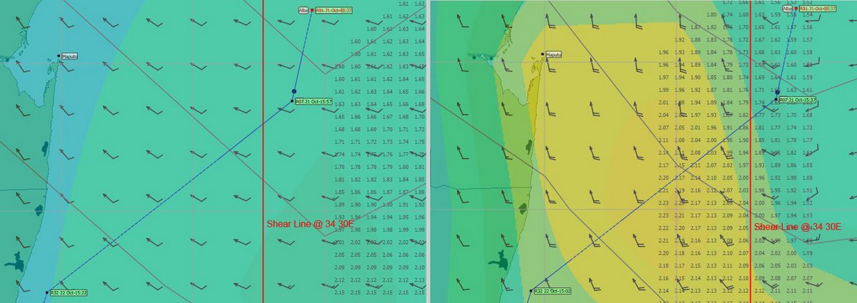
2017 Alba - When we were two days from Richards Bay, we had a strange anomaly in our GRIB files. I downloaded a low resolution (2.5 degree) GRIB in the morning and then a few hours later, I downloaded a high resolution (1.0 degree GRIB). The difference was astounding.
The low resolution GRIB showed no strong southerlies, while the high resolution GRIB showed a strong shear line with 20-30 knot south winds to the west of us. We turned south, stayed to the east of the shear line and avoided the strong head winds.
I'm not sure why there was an anomaly, but in future, I'll be getting a low res GRIB file for a large forecast area and a high res GRIB file for my local area.
4. NAVIGATION
4.1 Electronic Charts

We use OpenCPN with CM93 charts and Navionics charts on our 8” Samsung Tablet and our Raymarine Chart Plotter.
Both the CM93 charts and Navionics charts can be very inaccurate in this area, showing very little detail and can be out by up to ½ mile - they are okay for rough planning. Therefore I'm a great advocate for the use of satellite images for navigation.
There are several ways to do this, but the method I prefer is to produce KAP charts from Google Earth to use in OpenCPN.
The image shows our track in a remote part of the Anambas Islands, viewed with a CM93 chart and a KAP chart.
My KAP files can be downloaded from:
http://www.thehowarths/cruising-information/downloads
We have a separate article, if you are interested in more detail:
http://www.thehowarths.net/cruising-information/technical-notes/494-kap-charts-and-opencpn