
Last Updated: 18 September 2017
1. INTRODUCTION
We spent two months in Madagascar in August and September 2017 on “Alba” our Hallberg Rassy 42F. I was unable to find a definitive Cruising Guide for the country and relied on blogs and personal contact with cruisers who have visited in previous years. These notes are a combination of extracts from various blogs and articles as well as our personal experiences in 2017.
I've compiled another cruising guide on the Passage from Madagascar to South Africa.
Jason Trautz of SV Yolo produced a good guide in 2015 covering his experiences of Madagascar:
http://www.noonsite.com/Countries/Madagascar/madagascar-clearance-cruising-information
If you find any errors in these notes or want to add new information then drop me a quick message using our Contact page and we'll have an email conversation about it.
The latest version of this document can be viewed on line at:
http://www.thehowarths.net/cruising-information/cruising-notes
We kept a daily diary of our time in the Madagascar, which can be found at:
http://www.thehowarths.net/alba-chronicles/2017-indian-ocean
A set of GPX routes and waypoints (which will load into OpenCPN) can be downloaded from:
http://www.thehowarths/cruising-information/downloads
A set of KAP charts (which will load into OpenCPN) can be downloaded from:
http://www.thehowarths/cruising-information/downloads
2. MADAGASCAR
Madagascar is a huge cruising area, so I have split the country into five cruising areas: East Coast; North of Nosy Be; Nosy Be Area; South of Nosy Be; and the South.

There are many National Parks being created in Madagascar and you can be charged 55,000 Ariary per person per day. In particular - Nosy Hara. Interestingly Tani Keli near Nosy Be only charges 20,000 Ariary per person. Details can be found on http://parcs-madagascar.com/
3. GETTING THERE AND GETTING AWAY
3.1 Introduction
The best guide for the passages to and from Madagascar is written by Des & Nell Cason of SY Gambit, who lived and cruised in Madagascar for many years. It covers the strategy for getting to Madagascar from the Masculines and the Seychelles and most importantly gives great details and advice on how to get to South Africa via the Mozambique Channel:
http://www.noonsite.com/Countries/Madagascar/madagascar-cruising-notes
3.2 Rounding the Northern Cape of Madagascar
2015 Yolo: Cruising up the east coast: If you are anchored in Ile Saint Marie and want to sail all the way up the east coast of Madagascar, it will typically take you about three days. Pick your weather window carefully, so that you approach the northern cape in southern or southeastern winds of around 15 knots or less. Contrary to the Gribs, the winds and current really move at the northern tip, often twice the forecasted speeds! In forecasted 15 knot SE winds YOLO covered 100 nm miles in 12 hours, at times going 13+ knots double reefed! The current is like a freight train heading north along the northeastern coast.
2015 Yolo: Once you reach the northern tip, turn west and stay very close to the coast. Most yachts stay within a mile of land at the cape and I stayed even closer in 25 meters of water. In most cases you will now have the winds on the beam and you will be screaming along in flat waters. Try to time your turn to the west during slack water to avoid the clashing of the north bound currents. Vessels who sailed a mile or more off the coast really got hammered in the wind and waves.
3.3 Northern Route across the Mozambique Channel to South Africa
2015 Gambit: Article gives advice on how to get to South Africa via the Mozambique Channel with waypoints for anchorages in Mozambique to shelter in bad weather:
http://www.noonsite.com/Countries/Madagascar/madagascar-cruising-notes.
I've concatenated various blogs and other information into a separate article in our Cruising Notes.
3.4 Southern Route across the Mozambique Channel to South Africa
2015 Totem: A more unusual and direct route allowing you to visit the Barren Islands, but have to be fully committed with no place to hide in a southerly.
http://www.sailingtotem.com/2015/11/passage-hindsight-sailing-from-madagascar-to-south-africa.html
2015 Gambit: Down the west coast of Madagascar towards Toliara approx 180degT. This is a very pleasant part of Madagascar with lots of islands to stop off at, but you face a slight negative current coming up the coast and predominantly SW/S winds. This can become a bit frustrating if you are in a hurry. Normally yachties will head for Toliara or preferably Ifaty just north (highly recommended) and set off from there for Richards Bay. The draw back is that unless you can do 200nm a day you will get caught in a south westerly blow with no place to hide. If you elect the west coast stop at Morombe and then head for Europa Island and then Inhambane which gives you two hide aways en route to the Mozambique coast.
4. SECURITY
We have an article on Boat Security.
5. FORMALITIES
5.1 Overview
Jason Trautz of SV Yolo produced a good guide in 2015 covering his experiences of the formalities of Madagascar:
http://www.noonsite.com/Countries/Madagascar/madagascar-clearance-cruising-information
5.2 International Arrival in Ile Sainte Marie
2017 Alba - See our blog for the 16 & 17 August 2017:
http://www.thehowarths.net/alba-chronicles/2017-indian-ocean/543-august-2017-madagascar
5.3 Domestic Departure from Ile Sainte Marie
2017 Alba - See our blog for the 23 August 2017:
http://www.thehowarths.net/alba-chronicles/2017-indian-ocean/543-august-2017-madagascar
5.4 Domestic Arrival in Nosy Be
5.5 International Arrival in Nosy Be
5.6 Domestic Departure from Nosy Be
2016 Adina: Passing on information - Adina completed a domestic check-out with the Port Captain in Hellville as we intend to do our Madagascar international clearance in Majunga and we want no problems when we get to Majunga. We needed four crew lists, the port captain signed and stamped them all, kept one and told us to present the other three in Majunga. He also gave us a maritime clearance document. The port captain was friendly, efficient and there was no fee.
5.7 International Departure from Nosy Be
5.8 International Departure from Mahajanga
2017 Lusi - Our clearance was straightforward - go to Immigration at the container port, enter gate where it says passengers and locate the office near port captain. Fee was 20,000. Then proceed to office on tip of pt Sable as per pic. Enter office to the left. Young bespectacled guy did our paperwork and provided our clearance - 35,000ar. No local port clearance was asked for at either office. When asked, I said our last port was Ile St Marie.
6. WEATHER PATTERNS
6.1 Introduction
There is weather in the region - Work in Progress...
6.2 East Coast
6.3 North of Nosy Be
6.4 Nosy Be Area
6.5 South of Nosy Be
2017 Adina - Once you leave Russian Bay the only real all-round weather shelters are Baramahamay (Honey) River and Berangomaina. Stopping at any of the offshore islands overnight requires calm weather which becomes less common the more south you go due to the land and sea breezes strengthening. We had calm weather at Nosy Kalakajoro and were able to stay there. Once we got to Nosy Saba and Nosy Lava the evening east/south-east winds became stronger meaning over night we'd have been on a lee shore in the popular anchoring spots and it gets very bumpy. We used the tactic recommended by SY Gambit of anchoring off the mainland coast overnight.
We downloaded satellite images and looked for areas where there were breaks in the reef, shallows, mud or any extra shelter. Bing has better satellite images for this area; don't trust Navionics' depths inshore. We motored in slowly watching the depth and often anchored in 5-6m of mud, 300-500m off the shore. The only trick is the sea breeze dies off around 7pm so you get some initial bouncing but the peaceful night pays dividends. You could get lucky and get calm weather and not need to do this. We have found no decent internet access until now in Moramba Bay (Orange). Fill your water tanks in Nosy Be as clean water is hard to find and the bay's are murky/muddy. Similarly, stock up on fresh fruit and vegetables as these are hard to find.
6.6 Cap St Andre
7. NAVIGATION
7.1 Electronic Charts
We use OpenCPN with CM93 charts and overlays of KAP files that I produce from Google Earth. We also use Navionics charts on our 8” Samsung Tablet and our Raymarine Chart Plotter.
Both the CM93 charts and Navionics charts are very inaccurate in this area, showing very little detail and can be out by up to ½ mile - they are okay for rough planning.

Our primary charts are KAP files produced from Google Earth using the GE2KAP utility written by Paul Higgins (http://www.gdayii.ca/). These are very accurate (although some of the Google Earth satellite images are very low resolution in this area).
Cruising in this area would be more difficult without a good set of KAP files or using another way to view Google Earth images off-line.
Other cruisers use Ovitalmap on their iPad, but it is essential to download the satellite images into the application while you have a good wifi connection.
Another alternative is to use SASPlanet, which will also cache satellite images for use off-line. It can be used as a basic chart plotter with an interface to GPS via a serial port; and free access to Navionics charts, but it lacks some of the features of OpenCPN.
SASPlanet can download satellite images from other sources in addition to Google Earth. The Bing images are sometimes much better in certain areas. The GE2KAP utility can be used to create KAP charts from SAS Planet's cached images.
Good sunlight and eyeball navigation is essential practically everywhere.
My KAP files can be downloaded from http://www.thehowarths/cruising-information/downloads
A good explanation of how to create KAP files written by Ocelot can be found at:
http://svocelot.com/Cruise_Info/Equipment/KAPFiles.htm
7.2 Tides.
Total Tide has tidal information and we found the tidal predictions to be accurate. Navionics also has tidal ports in their charts.
8. EAST COAST AREA
8.1 Anchorages
The anchorages are listed heading north from Ile St Marie
|
Ambodifortra, Ile St Marie (17°00.04S 049°50.76E)
2017 Alba - Ambodifototra is the island’s only town. By 07:30, we were anchored at 17°00.13S 049°50.85E in 10 metres of water on sand/mud. The anchorage is a little rolly, but the inner harbour has moorings with no space to anchor. 2006 Niaouli - Guide in French. Produced a Mud Map of the anchorage. |
|
Ile Aux Nattes, Ile St Marie (17°05.54S 049°48.56E)
2006 Niaouli - Guide in French. Produced a Mud Map of the anchorage. |
|
Lokinski, Ile St Marie (16°52.44S 049°53.31E)
2017 Alba - We travelled past this anchorage when we rented motor bikes for the day and they are building a huge stone pier out into the bay. Ashore the village looked a bit dodgy, so we didn't anchor here. 2006 Niaouli - Guide in French. Produced a Mud Map of the anchorage. |
|
Antsiaka (16°50.28S 049°49.63E)
2017 Alba - We stopped here while waiting for evening to leave for .... |
|
North Ile St Marie (16°43.98S 049°58.34E)
Description |
|
Manompan (16°41.8103 S 049°44.8090 E)
Description |
|
Antanambe (16°25.64S 049°50.69E)
2006 Niaouli - Guide in French. Produced a Mud Map of the anchorage.
|
|
Cap Antsirikira (15°59.64S 050°09.14E)
2006 Niaouli - Guide in French. Produced a Mud Map of the anchorage.
|
|
Angontsy (15°15.13S 050°28.66E)
2017 Wairima: We sailed from Ile St Marie North anchorage to Angonsty. Looks horrible coming in with big reefs either side but flat and good holding in 5 m tucked in behind reef. We left Ile St Marie at 3 am to get there in light. Then did an overnight sail to get around top in light leaving at 9am. It's a rough sea 20 knots wind was enough ! 2017 Lusi: We only anchored once on the East coast - Angonsty. We anchored near the top of St Marie and left 0400 - arrived Angonsty 1630. Looked no good but was a good anchorage - slept well. From there we intended to stop but went out 35 miles and then long downwind tack to the top and around to anchor on the coast 4 miles south. So only one overnight. 2006 Niaouli - Guide in French. Produced a Mud Map of the anchorage. |
|
Vohemar (13°21.37S 049°59.24E)
2006 Niaouli - Guide in French. Produced a Mud Map of the anchorage. |
|
Nosy Akao (12°48.00S 049°48.48E)
Rumour: Supposed to be very rolly and only suitable in calm conditions 2006 Niaouli - Guide in French. Produced a Mud Map of the anchorage. |
|
Diego Suarez (12°16.24S 049°17.10E)
Rumour: It's a mission to get out of the bay against the south east winds. Tahuna 2015 - After our late night arrival near the entrance to the bay off Diego Suarez, we slept in a bit later than normal. Unfortunately, the winds that had died off during the night were soon howling again by mid-morning. We thought it would be a simple trip to the town of Diego Suarez just five miles away. But, the 30 knots of wind were on our port beam and we had wind and waves blasting spray over the entire boat on the way over. We initially went to a small bay near the town, but they only had moorings and it was not as well protected. So, we moved around to the commercial port and anchored near two large shipwrecks that were mostly submerged near the shore. That location has flat water and some protection from the wind, and it is quiet, but it has other drawbacks as we found out later. We had information that crime is a problem near the town, so we never left our dingy ashore and took turns going ashore. We found the town to be a cultural and visual delight each time we went ashore. We would drop ourselves off at a small ferry dock next to a half-sunken sailboat. Sometimes there were sheep grazing near the trash dump nearby. Locals were hanging out at a small cafe which was next to a building where women were often doing laundry. Going up the trash-filled dirt road near the cargo warehouses was not always pleasant. Later we would pass a large fish processing plant which had an awesome painting of fish along one wall. I took a cool picture of a tax in front of a cafe near there (which I really like). Later I noticed there are three languages on the cafe (Malagasy, French, and Spanish). Once in the town, we started passing an eclectic mix of old-style colonial buildings, in various stages of disrepair, and then we would happen upon nicer buildings with hotels, bars and restaurants catering to expats and tourists. There were a surprising number of older retired french men who were often seen sitting with pretty young local women. As we would walk through the town, we would often have local people offering to sell us things. There were numerous taxis of various types, and we soon learned that the long walk to the market could be saved by grabbing a tuk-tuk taxi and paying only 75 cents or a dollar for a ride all the way across town back to the docks. Before getting to the market, we found a nice supermarket called Score – that also catered to the foreigners – which had surprisingly good foods including cheeses, a large variety of drinks, a bakery, candies, and more. On the far side of town was a sprawling market that really surprised us. We have seen markets all over the world where we would buy fresh fruits and vegetables. They are usually a delightful way to see the real locals of a country. The market in Diego Suarez was stunning. A huge variety of local peoples from all walks of life. We saw the extremely poor and also locals who have moved up in society wearing modern clothing and using cell phones. We saw unusual types of foods, meats being butchered in the open air, live animals being sold, dried and cooked fish, pickled foods in plastic soda bottles, and more. There were kids of all ages just playing in the market, mothers feeding infants in the stalls, and of course there was trash everywhere. Fortunately for us, it didn’t rain while we were there because it would have been a muddy mess. But, we really enjoyed visiting the market and I really recommend reviewing the photo album below. There was one picture Gina of s/v Solace took of a baby playing in the dirt at the market. The photo didn’t turn out well on the camera, but I spent an hour or two processing it with tools I use. I really like how it turned out. Click on the image for a bigger version. One day, we were walking by some stores and spotted some very interesting wooden global maps. Then I saw some high-quality ship models as well. After a store attendant opened the store for us, we went to have a closer look. I was really tempted by the maps and one of the ship models which provided a look at the insides of a wooden sailing ship from the 17th century. But, I was shocked to find the maps cost over 600 Euros and the ship was 2900 Euros. They were excellent quality though. See the pictures in the album. After a few days, with 30 knot winds blowing every day, our boats were covered in red dirt from head to toe. Every step we took on the decks just spread red foot prints over everything. And, we noticed our sheets and halyards, even the shrouds, were covered on the front with red dirt. I had Karen take me up the mast and I washed the shrouds so the red dirt would be less likely to get on our new main sails when we deployed them later. Burglar! In the middle of the night, Karen heard some shouting and it woke me up as well. Karen got up to investigate first and she looked around the boat, but didn’t see anything. She came back to me and said she heard English. I said it must have been Paul and Gina on s/v Solace, so I turned on our radio. Next I tried sending a text message because I saw them shining a flashlight around the boat. They wrote back saying someone had came onto their boat and tried to steal a portable generator they had tied down in the cockpit. Paul woke up and shouted, and the man jumped off the boat into the water. There was a dug-out canoe waiting nearby. They discovered ropes had been cut on the generator, and later discovered two bundled ropes had been cut and taken off the bow deck. Paul and Gina were fine, but shaken by the violation of their property, and the realization the guy had a knife. The next night, we both implemented infrared security alarms on the decks of our boats. And the day after that, we decided to move our boats back to the entrance of the bay in preparation to head around the cape at the north end of Madagascar. The winds were forecasted to drop some the next day. Although, on our way back to the entrance, we were once again trudging our way through 30+ knot winds to the other side. Diego Suarez was definitely a memorable visit. But, we had stayed several days waiting for the weather break and were anxious to get around to the calmer waters and winds on the west side of Madagascar. |


9. NORTH OF NOSY BE
9.1 Introduction
2015 Gambit: Cap D'Ambre to Nosy Be inside the reefs and drop off, has many great anchorages and some yachties have spent up to 3 weeks working their way down to Nosy Be. There are no authorities up that way, so there is no pressure to rush. Some sharp operators will try and get cash out of you to anchor at some of the larger islands, especially Nosy Hao, but they can be ducked by producing a camera and insisting they pose with their ID documents. The threat of reporting their activities to the authorities in Hellville is usually enough to get rid of them.
Nosy Be to Cap St Andre is pretty relaxed and you could spend a couple of weeks cruising this section as there are a number of great places to stop over. If you are accessing internet via a local service provide you will have strong signal inshore down the NW coast all the way to Baly Bay. The wind up there is constant, but at least by staying in close you get away from the worst of the swell which is usually the problem.
As you will discover once you get to the NW coast, things get a lot more relaxed and these conditions hold good all the way down the NW slope to Cap St Andre (16deg S). The one element you must take into account are severe katabatic winds SE blowing offshore between Ananalava and Majunga, which persist the whole day and die at night. This kicks up quite a swell, up to 4m during the day, but obviously calms down to dead flat at night. Suggest you stay within 5nm, which is exciting sailing in flat water, till night fall. We and many other yachties have anchored offshore at night, as you will be sailing in 5-15m of water inside the drop off and if you can live with a bit of swell up to about 1900hrs, the rest of the night is peaceful. Would suggest anchor watch or radar guardsmen if you have it, as there are quite a few prawn trawlers operating in that area.
Cap St Andre is notorious for tropical squalls and lightning the closer you get to November, so if your timing puts you there in November - beware. A yacht 40m from us was struck at 0700 in the morning in Baly Bay which is something you don’t need, especially facing the run down the channel. If in doubt stay 20-30nm offshore and head due west to Mozambique.
9.2 Anchorages
Anchorages are listed from Cap D'Ambre heading south.
|
Mpaninabo Bay (12°00.9S 48°13.2E)
2007 Ocelot - S12°00.9 E49°13.2 24' (7.5m) mud Uninhabited. Can be windy. 5 miles to Cap d'Ambre. In 2009 we jumped off for the Seychelles from the farthest north anchorage we could find on Madagascar, that being the lovely Mpaninabo Bay (S12°00.9 E49°13.2). Carved out of limestone karst, this bay extends several miles inland from the coast and provides full protection from the swell. Because the surrounding land is fairly low, it can be quite windy, but we spent 2 nights here in comfort. The island in the middle of the bay has extensive shoals/reef surrounding it, and at high tide the water was not quite clear enough to tell how far down the rocks were. Be VERY careful. There's no one here but you. It must be one of the very few uninhabited bays on this coast. We did see some fishermen out during the day, but don't know where they came from. The tide is about 1.5-2 meters, and a couple nice beaches appear at low tide (as do the edges of the shoals). The loom of the Cap D'Ambre lighthouse is very visible at night, as is a lesser loom of Diego Suarez to the east. 2014 Inifini - S12deg00.8min/ E049deg13.2min; Mpaninabo Bay. We had a fast sail here, covering 1514 nm in 10 days, 2 hours; average speed 6.3 knots. We'll be updating this blog when we get SIM cards in Hellville, Nose Be (connecting to SailMail and Winlink has been almost impossible, and frustrating hours have been spent in the effort). We're so happy to be here; everything's fine with the boat and crew, and Team Infini sends hugs to all; we'll catch up to emails when we're able. 2013 Two Oceans - Once around the top the wind moderated somewhat and the sea became completely flat. Taking the pole down was quite a chore and after it was done we headed towards the entrance to Mpaninabo , an uninhabited and well protected bay. It was low water as we entered; tidal range in this area is about 3 meters and the fact was reflected in the shapes of the rocks in the entrance. We found a spot we liked and dropped the anchor; I watched the GPS plotter and it showed we were moving. It’s supposed to be a muddy bottom here so maybe I should put down two anchors in tandem. Once I did that we were stationary. The wind blew hard all night; taking the anchors out was a tricky operation, working with the engines to make sure there was as little pressure on the windlass as possible. It was high water and going out presented no problems, except of course for the wind which blew out of the southeast at 30 knots and more. As we went out of the bay I showed Gili the flat water to the south and promised it’ll be calm in about 200 meters. We opted for a conservative sail-plan: main and jib in second reef. We could always open up when the situation becomes clear. The wind, which abated for a while came back and we had to reef the main to the third position. Still, with flat water, we sailed fast, around 7-8 knots. |
|
Nosy Hoa (12°06.82S 049°02.31E)
2017 Alba - Didn't stop because it was blowing 30 knots.... |
|
Nosy Hara (12°14.51S 049°00.27E)
2017 Alba - 2013 Two Oceans - We planned on anchoring on the west side of the island in order to be protected from the prevailing south-easterlies but that anchorage was open to the west. At one point I asked Gili to take out the trolling gear; the the very same moment a fish was caught. I pulled it out to find a tail-less bluefish, a shark taking its share of the booty. We made a quick pass through the bay and went back to the east side, anchoring at 12 14.022 S 049 01.353 E. As evening arrived, the westerly died down and a light easterly sprang up. Memories of yesterday’s southeasterly surfaced and we quickly raised the anchor, seeing that my little trick was in fact improving the situation and motored to the bay on the west, where we noticed two fishermen boats on shore. Not long after dropping our anchor, one of them came over; it turned out this island is a part of a national marine park and there is a payment of 10000 ariary for each person on board. Oh, well…The anchorage on the west side was at 12 14.659 S 049 00.368 E. |
|
Ampisandava (12°15.60S 049°06.20E)
2017 Red Herring - Anchored 12 15.6S 049 06.2E off the yacht facilities/marina Ampisandava. Well one mooring ball, great place to beach a catameran. William, the French man here is so friendly and his wife we went to dinner last night for their daughters 5th birthday. Today we walked up to Windsor Castle 391m for fantastic views all over the north saw Diego Suarez and the entrance and bay . it is very close, almost see Cape Ambre and to south cape sebastian. Found old French gun emplacements from 2nd world War . Tired having a day off tomorrow but may go for a snorkel to find a ditched torpedo bomber plane in about 6m not far away. Wednesday a day trip to Diego Suarez and hopefully Mantagne DeAmbre then we will dive south more quickly and catch up with you all. 2017 Red Herring - Well Allah didn't want for us to go to Amber Mountain today so we are on our way to Mitsoi. It was all organised and a good place to leave the boat but late yesterday we had a visit from the resident ranger while we were on the beach. He knew all about us from the guys on the island and said we should pay again at the mainland. His boss was coming to the village in the morning (today) but we decided we didn't want to DISCUSS with him so cancelled. A real shame as the village misses out on so much. Yesterday the village kids took us on a mango hunt, it was fun but not many ripe ones yet. Found the the Blackburn Skua torpedo bomber in 4-5m but vis not that great, better with a bottle but we only snorkelled. 2013 Two Oceans - Our destination for the day was a waypoint where according to some report on www.noonsite.com a marina and a boatyard were located. My curiosity, as well as the need for the windlass base repair, made me decide to go and see for myself. The C-Map electronic charts were quite accurate and we skirted reefs, passed shoals of 4 meters depth and finally reached the target. Eagerly I watched the shore with my binoculars but could not find anything like a marina. A hint of a boatyard emerged when we saw a beached catamaran near a small village just a bit to the south of the given coordinates. The bay was open and not appealing at all so we turned towards Nosi Hara, 5.5 miles away. |
|
Cathedral (12°15.62S 048°57.68E)
2017 Alba - |
|
Nosy Tanga (12°26.32S 048°42.75E)
2017 Alba - |
|
Rantabe Bay (12°27.5S 48°45.0E)
2007 Ocelot - S12°27.5 E48°45.0 22' (6.5m) sand/mud Somewhat exposed. Beware wind shifts. In 2007, on our way south, we came gratefully into the lee of Madagascar after a pounding sail from the Seychelles. The northern tip of Madagascar extends far north of the visible mountains, so we were in lee waters sooner than we had hoped. Tired, but elated, we poked around the headlands with their black rocks and sturdy baobab trees (trees that look upside down!) to find a patch of sand for the night. We dropped the hook in Rantabe Bay (S12°27.5 E48°45.0) in 22 feet over sand/mud. One fisherman approached us and we traded lobster for clothing, which seemed to thrill him. In the morning it got rolly, with a small break on the beach, so we headed south. |
|
Andranoaombi Bay (12°26.7S 48°46.2E)
2007 Ocelot - S12°26.7 E48°46.2 19' (6m) sand/mud Well protected. A few small villages. No hassles. Had we had more time in 2007 we might have gone farther east into the deeply protected northern arm of Andranoaombi Bay to the east. There, in 2009, we anchored in 19 feet at low water, over mud, near the village of Ambaro (S12°26.7 E48°46.2). Far from the mouth of the bay, this anchorage afforded protection from the swell and chop kicked up by the onshore/offshore breezes. There were several small villages (of fewer than 10 huts each) scattered along the coast wherever there was a beach. We found the families friendly, curious, and eager to trade their meager offerings of limes, shells, eggs for whatever we had. Aspirin and T-shirts were at the top of their list. 2013 Two Oceans – We left Nosi Hara to the south; trying to keep a daily distance of not more than 30 miles, we found a long protected bay called Andranoaombi. Three villages were shown on the chart in the bay and we saw ourselves going ashore, doing some shopping for things we needed, like eggs, veggies and beer. On the way we passed the islands west of Hara and some of them were a real pretty sight. This cannot be said about Andranoaombi, which had no charm at all. With difficulty we spotted a single village, poor dwellings hiding behind the shrubbery. A small dugout canoe with three girls came for a visit. Interestingly they have a stabilizing outrigger on them here, just like in Micronesia. |
|
Maribe Bay, Nosy Mitsio (12°54.540S 48°34.691E)
2016 Adina - 12 54.540S 48 34.691E. Maribe Bay provides excellent shelter from both day and night time breezes. The sea breeze (onshore from the west) usually kicks in about midday while the land breeze (offshore from the east) starts at about 9pm. You will get canoes coming asking for things, the village is very poor and has little so don't expect much trading. Ashore is a village to visit. We had teenage girls show us around. While friendly, throughout the walk we were asked for things. Many yachts make day trips up to the beaches in the north of the bay and come back south at night. A very relaxing place to stay. 2015 Totem - 12°54.400S,48°34.650E,27,Sand, SW side of island. Easy in, with Navionic being accurate. It’s been a week since we made landfall. We might have kinda sorta not quite checked in right away, which you really should do, as failure can result in some unpleasantness…fines, expulsion, etc. But we hoped the angle a bit farther north would give us some sailing. Unfortunately, that also requires WIND… And we were keen to stretch out our official entry date just a bit. And we had a message from friends on Delos that they’d be up north a bit – wouldn’t we like to meet up? Why yes we would! This quiet village turned out to be the perfect place to ease into a new country. It’s intimidating, facing an expressionless crowd of villagers, all staring at you, when you land on the beach in front of their homes – while you wonder if it’s really OK to anchor in their front yard. In rural island cultures, it’s the norm to ask permission. In Fiji, we’d be bringing kava for the chief. In PNG, we’d have a fish for the village elder/leader. We had no idea what to do here, and we don’t speak French, so … well. A combination of the terrific French for Cruisers book, a little physical humor (Jamie entertained kids trying to juggle shells on the beach), and a smile seemed to make everything right. I think we locked that in when we traded a snorkeling mask and some fishing gear for four of the biggest lobsters I’ve ever seen. The guys asked for a picture…who am I to refuse?! It was all right enough we ended up on the sidelines of a soccer tournament / party. A team from another part of the island had walked more than two hours (on dirt footpaths–there are no roads) to get there: this field had recently been cleared, and the goals built, for the purpose of such an event. The home team, barefoot, was intimidated that some of their opponents wore shoes. Sounded like the perfect time for a little soccer ball diplomaDSC_4865cy, so we inflated one from our stash to donate. After some coaching in the appropriate words in Antakarana for gifting the ball immediately went into play! Because it would be surprising if our experience here unfolded in any kind of expected manner, it seemed perfectly normal that speakers blared dance music on the sidelines while the game was in play, and the event was also described as a “discotheque.” We got to do some serious hip-swaying while the game went on. Our days were filled with exploring. A small island nearby used to have a resort, but was empty save a fishing camp and a handful of ruins. Nice beachcombing. Crazy big trees (Mairen and Max demonstrate: you can put your WHOLE BODY in this one). Plumeria trees were left untended on the tumbledown resort grounds, their fragrant blooms just beginning to bud. 2015 Totem - We headed back to Nosy Mitsio from the bustle in Nosy Be Mitsio, looking for some quiet and new experiences. It’s humpback migration season, and we passed several pods along the way. Within a short time of settling in at anchor inside the deep vee of a bay, a dugout with two visitors came out. We’d probably have managed trading with our mix of pantomime and phrasebook French, but JP not only makes it easier- his skill means we get to know Sharaf a little better, while we trading a collection of clothes and household goods (some needles and thread) for some lobsters. Sharaf came back to Totem the next morning while French toast was flying off the stove, with a handful of shark’s teeth and a dozen or so limes to trade. We took the opportunity to add a plate for him at the table and with JP’s help, learn more about his home. It’s still imperfect, because Sharaf’s French actually isn’t all that great, but we learn a lot over breakfast from this soft spoken man. What he fishes. What he farms. The age of his son. Afterwards, he takes us on an extended walk that lets us see first hand what life in a rural corner of Madagascar looks like. The village school. The dry fields where rice is grown during the rainy season. Which trees are used for building homes, which are used for boats, and where they come from (an island to the north, Nosy Lava; most of Mitsio is bare). The pens where zebu are kept. The fences up around banana trees, which wandering goats would otherwise mistake for tender forage. Everyday village life: simple homes. Rice drying on a pandanus mat. Pandanus leaves being stripped to use for weaving. Jamie uses physical humor – making a mess of trying to juggle shells on the beach – to turn these cuties into a writing mass of giggles. Non-verbal communication for the win! For the record: I cleared taking this photo with their mom first, and she clearly appreciated it. Tucked in the shrubs was this funny looking flower. See all the bugs around it? There’s a reason. (this may or not be the species “discovered” in 2012…but we’re in the right place, and it sure looks like the one described) This “flower” is nicknamed Corpse Flower: a bloom with a truly wicked stench, and the oddly wicked name – Amorphophallus (that would be the green spikey bit). It’s earned ‘corpse’ because IT REALLY STINKS. And yet… Sharaf felt compelled to demonstrate. Which in turn we felt we had to reciprocate. eeewwww! I spy this gorgeous Japanese fishing globe in a heap of broken plastic fish floats. A jewel among the no longer useful. We try trading for it, and initiaallit looks like we have a deal, but another villager steps in and asks an outrageous sum. We were prepared to be generous, but not to the extent of the average per capita income, so we’ll just have a photo for a memory. Back on Totem, we’re having fun introducing JP to our life. The ritual of a sundowner: sitting in the cockpit for some snacks and a glass of wine while the sky turns pink. It’s lovely. And it feels ridiculously privileged after our walk through Mitsio’s simple villages. And we discover that Sharaf has left all the shark’s teeth and limes, a quiet departure gift. 2013 Two Oceans – Today’s destination is Nosi Mitsio which some people described as "a must" mentioning the availability of lobsters from local fishermen. Good sailing to start with but quickly the wind went forward an down to less than 10 knots so it was motoring again. At least the batteries get charged. Approaching the northern entry to Mitsio we saw a yacht, a Privilege catamaran at anchor near a nice sandy beach; we went on to Maribe bay in the south which is protected from all directions except the north. We saw a village on shore, with some huts looking as if they were part of a resort. Not a lot of people on shore but we did get visitors; three young kids on a canoe with a colorful sail came by to ask for anything we could give. Gili gave them some of her old cloths. A single man came and offered "Langouste" but he could only deliver next evening. Instead we accepted his offer of coconuts and papaya. He went ashore for the goods, came back with four small coconuts and a big shell. We didn’t want the shell and when I offered to pay for the nuts he made it clear that money was of no use for him. He actually wanted a spear for his old gun. That I didn’t have but decided to let him have one of my old diving masks. This made him happy. Three men passed by on a relatively large wooden boat, maneuvering expertly with their lateen sail. The Privilege left her anchorage and found a place near us; their dinghy came over with a young Malagasy, Anselm, who was one of a two man crew on it. They work for a charter company and I used the opportunity to ask him about repair facilities on Nosi Be. After a bit of a palaver he went and brought two useful telephone numbers, a fiberglass repairman and an official of the Maritime authority who is maybe a relative. "Tell them Anselm gave you the number". 2007 Ocelot - S12°54.5 E48°34.7 27' (8m) sand/mud Delightfully relaxing. About 25 miles south of Rantabe Bay we eased our way between the rocky buttresses that flank northern Nosy Mitsio and anchored inside the bay at S12°54.5 E48°34.7 in 27' (8m) over sandy mud. This was a lovely place, with several small thatch-hut villages along the shores and nice hills for walking. You can leave the dinghy on the beach and explore. We found the people friendly and happy to have us wandering their hills and footpaths in the warm sun. They are a bit spoiled when it comes to trading, however, as charter boats frequent this bay and the tourists are happy to part with Euros or dollars for lobster, goat or fish. We struggled to trade lobster for our filet knife, mask and snorkel and fish hooks. Speaking French is very helpful. This island group is reported to have good snorkeling/diving near some of its northern islets, (upper left, and center, in the photo) but we were busy with a yacht rescue and didn't have time to check it out. Local trading dhows often come here from Nosy Be. It's fun to see how they careen the dhows on the beach at low tide, off-load the goods, then wait for the rising water to set them afloat again. So who needs an anchor?? |
|
Ampasindava, Nosy Mitsio (12°50.782S 48°36.679E)
2016 Adina - (12 50.782S 48 36.679E) 8m at HW, Sand. Daytime stop with land breeze from the east so typically best in the morning. Long beach, clear water." 2015 Totem - 12°50.212S,48°36.570E,33,Sand,Anchored 0.1 miles south of last time and bottom had fewer bommies.
|
|
Anikarea, Nosy Mitsio (12°50.567S 48°35.028E)
2016 Adina - 12°50.567S 48°35.028E 7m at LW,Sand. Popular daytime stop, including snorkelling. If winds are light it's fine to stop in the morning but if there is a strong easterly land breeze then it's bumpy and better to stop at Ampasindava first. Around midday winds swing around to the west. Boats typically stay here until sunset and then head back to Maribe Bay 3 miles to the south. 2015 Totem - 12°50.418S,48°35.022E, 33ft ,Sand / Bommies, Bommies prominent, so hard to keep chain off coral - best to float chain. Good afternoon wind protection, but not protected from night winds.
|
|
Tsarabanjina (13 01.47S 48 32.77E)
2013 Two Oceans - A short trip today- to Tsarabanjina, a resort island about 10 miles away. We first went to the southeast side, where the snorkeling is supposed to be good. For the first time since we came to Madagascar we were able to enjoy clear water and nice, healthy reef. We then went back to the northwest side, where the resort is located. Anchored at 13 01.474 S 48 32.776 E 8 meters on sand, good holding. The C Map is not so accurate here as you can see from what it showed as we were passing the island northeast corner. In the late afternoon we went ashore for a beer and internet. Succeeded in getting the forecast and our e mails but could not publish to the blog, the internet was so slow! Oh well, tomorrow we go to the big town, Hellville and do it from there. As night fell the wind changed direction and became easterly; this seems to be the rule here. In a short time it raised waves at our anchorage. A traditional looking schooner, which came in just as we were sitting at the resort’s bar, anchored on the west side of the island, about 13 01.57 S 48 32.69 E which seems to be the better place to take. We rolled through the night with the wind topping at 28 knots. I was happy to leave at 0700; the sea outside was smoother than in the bay! After about two hours the wind started the diurnal change and moved to the south, losing strength.
|
10. NOSY BE AREA
10.1 Anchorages
Anchorages are listed heading south.
|
Hellville, Nosy Be (13°24.450S 48°17.044E)
2016 Adina - 13°24.450S 48°17.044E 8m,Mud. If checking into Madagascar you need to visit the police who act on behalf of immigration and can be found in the port in a small portacabin (13 24.462S 48 16.834E). They are corrupt - they show you a hand written note in a book stating check-in is now 80,000Ar (26USD) for a "droit d'arraisonnement", we saw in their receipt book they were charging yachts in 2016 anything from 60,000Ar to 240,000Ar (20 to 80USD). You need 2 copies of your last port of clearance plus 2 copies of your crew list. You pay them the fee plus standard visa costs and then return to collect your passport at a time they tell you. After this you need to clear in with the Port Captain (building at 13°24.4201S 48°16.7349E). Walk out of the port gate, follow the road that bends to the right, they are on the corner on the right. They will issue a cruising permit for Nosy Be and surrounding islands, we were told the minimum length issued is 1 month, we paid 59,310Ar for this 1 month permit. They didn't ask for any extra fees and used official documents. If you don't speak French it may help to use one of the "boat boys" like Jimmy and Cool who will charge you 30,000Ar (10USD) but to note they do as the officials tell him. Jimmy and Cool are helpful for looking after your dinghy (5000Ar half day/10,000Ar full day), getting fuel/water and any other information. Jimmy wears a red Mount Gay Rum baseball cap. We later did a domestic clearance with the Port Captain. This required 4 crew lists - he stamped and signed all 4 and kept one. We were given a domestic clearance document - no charge. Tuk-tuks to town are cheap at 500Ar per person, good fresh market, Shampion supermarket and assorted restaurants - Nandipo is where yachties hang out and Oasis Caf‚ for coffee and cake fixes! 2016 Tintin - 13°24.347S 48°17E, very muddy, 7 meters. We arrived in Hell Ville (Andoany) 27th August at 0830 hrs for our Port Clearance, the 2 month Madagascar Visa and 1 month Cruising Permit for Nosy Be. Just as we dropped anchor we were met by Jimmy and Cool who had canoed out to welcome us. These guys have a good reputation with cruisers and were recommended to us for assisting with all the check in formalities. They also saved us time re finding the ATM and Mobile Phone shop, the 2 most important things we need in any new country, ie local currency and Wifi. The guys also organised a babysitter for “Snowy” our tender as the port, though rather small is very busy and there is just nowhere to leave your tender. The Clearance Process (NB Saturday) was relatively pain free with no real surprises. We were taken to a small tin shed where at least 12 Police, mostly females were watching TV, one was doing her fingernails and the majority were on their mobile phones. We paid for our Madagascar 2 month Visa and the Police Fees for who knows what???, we did get a receipt and waited for our passports to be stamped, and waited we did! The Police were interrupted firstly by the Minister of Police and Immigration, secondly by the photographing of the Police with 3 men caught for robbing a yacht or 2 in Crater Bay and finally the arrival by boat of a famous “Pop Group” here for the festival that night. We can’t complain, it was very interesting watching the above and once we got our passports back and stamped it was off to the town centre in a Tuk Tuk to explore, have lunch and a cold beer. BTW the festival was held just opposite where we were anchored it started around 2100 and finished around 0600……..can’t say we enjoyed the music either!!! On Sunday we headed off to Nosy Komba, then back to Hell Ville Monday to pay for our Cruising Permit as the Port Captain was closed over the weekend. Another day in Hell Ville to complete Checking-In formalities and pay for 1 month Cruising Permit for sailing around Nosy Be, then off to the Market to buy fresh fruit and vegetables. The daily market is both in the town market building (a permanent structure) and hundreds of stalls lining several streets, running all the way down to the waterfront. This market is the best fruit and veggie market we have been to since leaving Thailand, however we were put off buying any fresh meat or seafood because of the huge amount of flies. The streets surrounding the market building are full of stalls selling everything from exercise books to coal for cooking. We love visiting the local markets as it is a great way to mix with the locals, and see and buy the local produce. This is the spot to buy the local vanilla and a variety of spices and all kinds of pepper. We found the Malagasy people to be friendly and welcoming, humble and warm, however they do not like confrontation. There is far less rubbish here, and hardly any plastic "water bottle litter" on land or water. The majority of Malagasy people can't afford to buy water in plastic bottles, most go to the local well, so therefore far less litter, very different to the "huge " amount of plastic bottles littered all over Indonesia, Malaysia, Thailand, Sri Lanka and the Maldives. Interesting note, we hardly saw any elderly people. According to the latest WHO data published in 2015 life expectancy in Madagascar is: Male 63.9, female 67.0 and total average life expectancy is 65.5 years, which gives Madagascar a World Life Expectancy ranking of 137, FYI Australia is: 83 years. Also the Malagasy people must pay to send their children to school, if you cannot afford the fees, your children do not go to school. Many of these children work as labourers in the fishing industry, wander the streets trying to sell food snacks in the hot sun, or as domestic servants. 2007 Ocelot - S13°24.4 E48°17.0 31' (9m) mud Shoals rapidly towards land. We anchored off Hellville town at S13°24.4 E48°17.0 in 31' (9m) over mud. Be careful going far into the bay - it looks nice and open but it shoals rapidly near the edges (probably an old reef). If you haven't already, read the cautions on dinghies here, written above. 2016 Camomile - Tuesday we motored back to Hellville to see our friends on Norsa and Solstice arrive from Mayotte. We all went ashore so they could check in and then met up later for lunch at our favourite cafe called the Oasis. Built in a Parisian street cafe kind of style the food is very good but the best are the chocolate brownies with a nice cappuccino. Yum Our first full week in Madagascar started with the chaos that is Hellville, the biggest town on the island of Nosy Be. The name means ‘big island’ and is pronounced ‘nossy bay’. It’s thought it was settled as long ago as 1649 by the English but the colony failed due to hostile natives and disease. They have had various arrivals since, Arabs and Comorans, but it finally came under the protection of the French in 1841. More recently Europeans have created a holiday resort of the island with many French and Italians settling there. We anchored at 13°24.375S 048°17.059E Hellville was named after Admiral de Hell a former governor of Reunion island further south rather than an evocation of the state of the town. It’s one of the places yachts can check in. A lot has been said about the government officials here and it’s very difficult finding any common ground. There are two locals here called Jimmy and Cool, Jimmy will walk you around the various officials which, if you don’t speak French, is necessary and Cool will mind your dinghy for you as there’s no dinghy dock. It will be moved around but we felt they needed to be trusted and we had no complaints. We work on 4,000 Ariary to 1GBP and Jimmy charges 30,000 and Cool 10,000 for the day to look after your dinghy so we aren’t talking big money. Unfortunately our photo of Jimmy didn’t come out but he’s on the left of this photo in the the red t-shirt. This also shows the chaos where you have to come ashore. We went ashore first thing on the morning of Monday 29th August and the fun began!! The first people to see are the police, they have an office/portacabin on the waterfront. They filled in an arrival form for us then said the person to stamp the visa wasn’t there so Jimmy took us to their office in the town. The tuktuk fares are 500AR per person for any journey which was 25p for the two of us. We got off at the bank to get some money out of the ATM. It issued us with 10,000AR notes which are worth about 2.50 so Bill ended up with wads of money in his pocket which is never a good idea. Continuing on to the visa office but the guy we needed to see wasn’t there either. A little word about tuk tuks, forget doors and windows, forget MOTs, forget health and safety, just go for a ride! We went back to the police dock and said we couldn’t find him and, after various suggestions, all of which would have cost ‘bribe’ money, it was agreed we would go back later. Then it was onto port control who were very efficient and it cost AR61,000 for a 1 month cruising permit for the Nosy Be area. (Note to sailors following us , you only need a permit for the month you’ll be in this area even if you have a visa for 2 months as we did.) The next stop was the Orange shop to set up a sim for the phone with internet access passing the local prison on the way. Remind me to behave here, can’t imagine the squalor that would be behind these walls. Continuing along to the market. We made our way back to the port to meet Jimmy at 2.30 to get our visas stamped. The guy still wasn’t anywhere to be seen and it was suggested we go to the airport to find him. I refused that because it wasn’t a weekend and I knew it could cost 30,000 plus in a taxi each way. The police were also after their ‘payment’ asking first for 120,000 but we refused saying other cruisers have paid 80,000 which they accepted. This is only about GBP20 but as we knew it was simply a ‘bribe’ we weren’t happy about paying but you have no choice. If you don’t pay they won’t check you in and can then arrest you – having seen the prison, we paid. We went back to the boat and finally at 4pm he turned up and we were able to get our visas which cost AR100,000 per person. At the end of the day we paid less than GBP100 for the whole thing which was far less than the other countries in the Indian ocean but it all felt a bit tacky. At last we were able to host the Madagascan flag I had made. The next morning it was back into town for shopping. This is the car park outside the supermarket. Isn’t he lovely? Its called a zebu and they are every where including on the meat counters for sale! The supermarket had a lot of French products and wine so we had a little stock up. The fruit and veg weren’t as good as the market but we found in the following days that certain days after a delivery the stock was better. We’ve got various leaks in Camomile’s water system and Bill needed some tubing. This man was very helpful with his little bit of English and Bill using a little bit of french he managed to get what he needed. The traffic is a bit chaotic here with a mixture of cars, tuk tuks and zebu carts. Back at the port we watched the most extraordinary scene where they were loading cars and fairly big trucks onto a local ferry. I’ll try and post a video on facebook. How they didn’t sink I’ll never know. Jimmy was watching and our dinghy had been pulled up onto the side. This is why you need to pay Cool his AR10,000 to watch your dinghy. The truck was held up while our dinghy was launched. 2015 Totem - 13°24.438S,48°17.068E,27,Mud, Easy in. Excellent holding, but exposed to the SE trades, which blow more at night as day has a land that locally, reverses trade winds. 2014 Inifini - S13deg24.459min/E048deg17.039min. We spent the entire morning (0715 to 1215) checking into Madagascar with Officialdom. We had made arrangements to meet our boat boys at 0730, and they were at the wharf promptly to take our dinghy and petrol jerry jug to allow us to meet our taxi. The boat boys here ensure the safety of the dinghy because there is no proper place to tie up to. I took my outboard engine key and fuel lines with me when I got out of the dinghy....Unfortunately, the taxi guy never showed up, and after waiting 45 min we used another taxi driver and had a pleasant chap, Sergio, along as interpreter. (Details: we used Jimmy as boat boy 0328479237, and Sergio 0347238698) It got a bit complicated as we had to first check in with the Policia, then go to the bank for local money (all fees have to be paid in Ariary), then Immigration, then Customs, then Treasury, then the Port Captain, and finally back to the Policia for the final stamps and signatures into our passports. Everyone was very pleasant and total monies were approx $125USD for two people for 3 month clearance. We then took a lunch break at the Papillon Restaurant (rated highly), went to the Orange shops for SIM cards for phone and data, and did a bit of shopping at the Champion and the "big market" (Ahkam Market). We had hired the taxi until 5pm and returned to the wharf at 5 pm sharp where our boat boys helped load the dinghy and we returned to Infini tired but a bit ahead of the game. Tomorrow we'll get diesel, pick up our laundry, and do more provisioning. Also of note is that the anchorage here in the present SW wind is quite rolly and uncomfortable, so the sooner we provision and get going the more sleep we'll get.... We topped off with diesel (gazole) at 2860Ar/liter and gas/petrol (essence) at 3560Ar/liter. At this time, the exchange rate is $1.00USD is 2360 Malagasy Ariary; 10000MGA's is $4.24USD. Going to the bank is interesting; you walk away with over a million Ariary in your pocket; no bill is over 10000Ar, but it all goes fast! Free internet and pretty good, very thin pizza can be found at the Nandipo Cafe. Jimmy and his helper had deposited our jerry jugs on the side deck of Infini, met us at the wharf, and we loaded up the dinghy with more provisions, this time fresh veggies and fruit from the market in the center of town. This is a large market, taking up a city block, and has lots of great fresh stuff. We couldn't wait to get back to the boat and prepare the huge prawns we had bought there, along with the fresh baguettes and salad makings. There was a nice rain shower during the evening and the decks finally look a bit better. 2013 Two Oceans – As we approached the pass between Nosi Be and Nosi Komba we had to roll the jib and resort to motoring. Both islands have a lot more vegetation than the ones we saw in the north. We came into Hellville’s bay and started looking for yachties to ask for information about the place to fill up water and to put the dinghy when going ashore. The only people we noticed were two young Malagasies on a Dutch flagged ketch; when we presented our questions they said:"Just anchor, we’ll come and give you all the information". They came by with the ketch’s dinghy, jumped on board before we could say "NO!" and pointed the dock where water could be had. Those two were our introduction to the Hellville boat boys, who will energetically do everything to earn their livelihood. We squeezed between a barge which was being filled with beer crates and a dilapidated cargo boat. More boat boys showed up trying to take a part in the operation and hopefully the gains. After our tanks were full we went back to anchor. Abdou, who also calls himself Jacques, called when we were on the way to the bay. Anselm, who gave us his number called at least three times to make sure we contacted his man. We put a big laundry bag and our garbage in the dinghy and rowed ashore. Everybody we met warned us about outboard theft and so we followed the advice and left ours inside the boat. We could see that all of the yachts in the bay were doing the same thing. On shore we met Jacques, who came ready with a lad to take care of the dinghy and a taxi driver to take us to wherever we needed to go. First to the Air Madagascar office to try a arrange a place for Gili on a flight from Nosy Be to Antananarivo; we tried that in Antsiranana but were told all the flights were full and the only one we could only get was Antsiranana to Tana. Again, no success. Jacques suggested the way Gili should go, which is take a fast ferry to the nearest town on the mainland and then go by taxi 5-6 hours to the airport. He called a friend from Antsiranana who would be able to do the trip. Gili is not pleased at all but that’s the only option. Next the ATM for more Ariary, the "Shampion" supermarket, which is supposed to be the best in town, the local market for fruit and veg and back to the port. The boy with the dinghy appeared mysteriously and we rowed back to the boat. Gili hoped for dinner ashore but that operation is so complicated, we gave it up for a pasta dish "at home". 2013 Two Oceans – At dawn the local boats bringing goods from the mainland started flocking into the harbor; engineless and using sails only, they glided into the bay, dropping the lateen sails and coasting to rest on the muddy bottom which the falling tide revealed. We went Ashore for a few things we wanted to do. Jacques was waiting for us and together we went to the harbor master for what I expected to be a courtesy visit. It turned out to be a very different matter. The HM wanted to see my papers and especially my port clearance from Diego (Antsiranana). I had a paper that I believed to be the right one on which the words:"Valid for all ports" etc. appeared. The HM said this was not enough and that I had to have a clearance to leave Diego. I was very upset, because I specifically told the lady at Diego port control I was going south and she assured me I had all the papers I needed. The harbor master, with Jacques helping in translation, showed us a document which stated that if you go out without the required document you have to pay a fine of 1.000.000 Ariary. Yes! one million! That’s about 430$ U.S! A long discussion ensued, with calls to the chief in Diego; it took quite a while until Gili succeeded softening the man in Diego. We ended up by having to write a letter of explanation of the mistake or misunderstanding that occurred and just paid the 35000 for the clearance we should have gotten in Diego. You can never be too careful with the authorities in countries like that, especially when the language is a challenge. Then to the market, where Jacques took us to meet his wife, who works in a food stall in the market; it was nice to see the way he related to her. "She works more than most men" he said. He also took us to see his home, where we collected our laundry, which he took care of. The way people live here stresses how fortunate we are with our standard of living and our way of life. We got Jacques’ phone number as a fiberglass repairman, but he turned out to be a general guide about town and a great facilitator in all our needs. If anybody needs a helping hand around Hellville – I warmly recommend him. His phone number is 0320415896. Gili is leaving the boat tomorrow, going to Antananarivo and catching a flight home via Johannesburg the next day. Her taxi to Diego will pick her up from a place called Enkify. We decided to sail and pass the night there. We had difficulty finding it; our C-Map chart was a bit confusing. Following local boats we finally got there and anchored near that uniquely looking place, a terminal of wooden huts built on stilts at the end of the main road leading inland. |
|
Nosy Be Land Trip(xxxxxxxxx)
2015 Tintin - We spent a day touring Nosy Be by land, Nosy Be means "big island" in Malagasy, though the island has several nicknames including “Nosy Manitra” (the perfumed island). Firstly, we visited Lemur Park, a natural and botanical reserve in the middle of a plantation of centenarian ylang ylang trees. We saw fauna and flora endemic to Madagascar, including a wide variety of endemic lemurs, wild ducks, the Madagascar Boa, beautiful chameleons, the green Gecko, a 206 year old Seychelles Giant Tortoise, crocodiles, and turtles. Lemur - Gidro Varika, usually live in groups of 3 to 12 individuals with multiple males and females We also visited the MCPS (Sociéte Products Perfume of Madagascar) distillery founded by the missionary Fathers in 1889, and world's largest producer of ylang ylang. Ylang ylang actually means “flower of flowers” and was given this name because of its sweet, floral scent. Ylang ylang oil is one of the key ingredients used in the beautiful perfume Chanel No. 5! The tree’s barely visible golden-yellow flowers are prized for their sweet, precious perfume. At maturity, the base of the petals becomes tinged with red, which is an indicator of harvest-readiness. Picking takes place throughout the year and early in the morning, ending at 0900, to preserve the aroma as much as possible, as it is reaches peak concentration at this time of the day. Ylang blooms all year, with an intensified flowering period between November and March. The very fragile flowers quickly lose their scent, so they are processed the day of harvest. Ylang Ylang complete essential oil is obtained by steam distillation of the flowers. The distillation process is very long, requiring about ten hours. The oil is exported to France. Next stop was the sacred tree. This is an important part of the Cultural Heritage of the people of the Sakalava (the majority Tribe of Nosy Be people). The sacred tree is a giant banyan tree that dates back more than 200 years. Apart from its age, it’s amazing reforestation extends up to 5,000 m2. We had to dress in the sacred dress and enter and exit the sacred tree area with right foot first. The trees roots are draped in red and white material, the colours of the Sakalava Royalty. This place is a place of prayer, where the locals come to pray for help, wealth and health. They bring offerings of red and white tissues, honey, rum, zebu and zebu blood.The Sakalava people believe that when men die, their spirits are reincarnated and they are the ones who watch over the living. After lunch we drove up to Mount Passot a volcanic hill in the centre of the island with views across Nosy Be Bay, the Radama Islands (south) and Mitsio Islands (north). With its 329 meters above sea level, Mount Passot is the highest peak of the island. There are eleven volcanic lakes on the island, that are supposed to provide fresh water for drinking and irrigation??, and we were informed full of crocodiles. We passed through the village of Dzamanzary the second largest town place in Nosy Be. Dzamanzary people relied mainly on the sugar business and the derived products (sugar, rum), however the main activities are now the plantation of Ylang Ylang and tourism. Fady's are rules that concern situations as well as people, animals, locations or a certain behavior. For example, a location that is used for sacrifice and only open to certain persons can be fady (sacred). However, it can also be fady (forbidden) to wear red clothing during a special event such as a funeral, fady to go to the bathroom in one place repeatedly, fady to fish on a Thursday, wash clothes on a Tuesday, point a finger at graves, fady that you must wash hands and mouth before entering a boat and the list goes on and on. Very interest, very confusing. People, places, actions or objects may be the subject of fady, which vary by region within Madagascar. The taboos are believed to be enforced by supernatural powers, and are particularly connected with Malagasy ancestor worship. So now back to Hell Ville to stock up tomorrow on food and local rum and enjoy lunch at Nandipo where yachtsmen and ex-pats mingle, before exploring more of main island of Madagascar and the islands. 2016 Camomile - Sunday we headed back to Hellville to meet up with Solstice and Tintin ready for our day trip around the island of nosy Be. Monday 19th saw the 8 of us going ashore and getting into a reasonable 10 seater minibus with air-conditioning for our day trip. It had been arranged through Roland, the guy who runs the chandlery in Crater bay. First we went to Lemuria land where we saw several types of Lemur such as ring tailed lemurs, crowned, and black and white ruffed lemurs. There were also crocodiles, chameleons, iguanas, tortoises, to name but a few. The group continued on to the ylang ylang distillery where girls had picked sacks full of the flowers to be weighed and registered to their name. They are expected to pick in the region of 20kgs a day, which is a lot of flowers, and they would be paid the princely sum of the equivalent of $5! It would take them most of the day to do this so very low wages. The flowers are distilled into essential oils and of course there was the obligatory shop where we were offered a juice and some little tidbits while we looked around. The prices were very reasonable so I treated myself to a few things. Back on the bus and on to the ancient sacred banyan tree. It was necessary to be covered for the visit and we were all ceremoniously wrapped in sarongs before we could enter the grounds. The tree covered a vast area, it was difficult to find the original trunk. Many of the branches had sent out shoots which hang down towards the ground and take root forming branches of their own. It was eerily quiet as we walked around the path in between the many branches with our guide. The last item on our itinerary for the day was Mont Passot, the islands highest point. On the way up we passed a series of deep blue crater lakes said to be the homes of the spirits of the Sakalava and Antakrana princes and some rice paddy fields. We stopped to take photos but sadly the area had been taken over by tourist stalls. Continuing to the summit of 326m which gave us the most amazing views. The last section was walked and led to a series of platforms so that you could get clear views in all directions. (Although the photos didn’t come out very clear) There was a bit of an afternoon heat haze but it was possible to see all the way north to Nosy Mitsio and south west to Russian bay and beyond. Stunning views. During the drive back our guide was able to give us lots of information about the Malagasy people, it was a great day out. The average life expectancy is 62 for men and 65 for women. 1 in 5 children die before the age of 5. There’s no welfare state and school in not compulsory. Many families can’t afford to send their children to school and there’s a 35% illiteracy rate. It was a interesting day. The whole trip for 8 of us including the van and driver, English speaking guide, and entrances fees but not the lunch cost 210 euros which was 53E per couple plus some tips which we all agreed was good value. Roland’s details are This email address is being protected from spambots. You need JavaScript enabled to view it. (photos for all this when we get to south Africa) 2014 Inifini - Road trip to Ankarana National Park and Diego Suarez. (We took a mooring at Crater Bay Marina (20000Ar/day) for our trip north. After a taxi ride to Hellville, our Malagas friend, Sergio, accompanied us and everything was so much easier with him interpreting and leading the way. He seems to know about everyone everywhere, and we were definitely in good company. We arranged for the fast boat from Nosy Be (Hellville) to Ankifi. This is a 30 min ride, compared to the 2.5-3 hour trip on the regular passenger or car ferry. Once there, we wondered about the fast boat, as the taxi-bus we chose waited an extra two hours for a few tardy passengers, thereby negating our time advantage. Oh well…”mora, mora” is what is said locally. It means “slowly, slowly…” We finally got going close to noon, and made it to Ankarana by about 4pm. The road is some of the worst you can possibly imagine. A 4 x 4 was a very expensive option instead of the taxi bus but, believe me, no one can negotiate the deep ruts, holes, broken road, and drop-offs that much faster than anyone else. Most of the larger taxi-buses are Mercedes diesels, and have really racked up the miles going back and forth from Ankifi to Diego Suarez. At any rate, our impressions of the ride are numerous, and I’ve tried to give a flavor of it all. Here goes…because we got such a late start, dozens of school children were walking single file down the road to (from?) school. Their blue shirts stood out, but everyone, small children included, know to jump way off to the side of the road when they hear any vehicles coming. You see, the buses are swerving all over the road and shoulders of the road to try to avoid the holes; an impossible task, but one that makes for a slow ride and allows time, if one is a tourist, to take everything in. People were tending the road, their fields, and their small yards. Chickens and zebu are numerous. There’s no electricity or running water anywhere, so villages are composed of small stick huts, with a small open fire to cook by. The countryside is beautiful, and long grass sways in the wind. Mango trees and baobob trees were numerous. Smaller trucks and buses carried way too many people, their belongings piled 6 feet high on the roof and tied down. Many people rode bicycles, stopping frequently for ruts and drop-offs. Building materials and vegetables for the market place were carried in large wicker baskets. There weren’t that many motorbikes, and a compulsory helmet law is in effect. Police check-points are placed to effect security, and the passengers are scrutinized, driver’s papers are checked, and a small gratuity is usually made to ensure rapid transit (or you may sit and wait). The men were dressed in shorts and T’s or button down shirts; women wore colorful sarong-like dresses, often with a matching head and neck scarf. Many women carried heavy filled baskets on their heads, and many people carried those ubiquitous yellow rectangular containers filled with water. Each container probably is 5-6 gallons; so probably about 40-45 pounds of weight there. This is a very poor, agrarian existence in one of the poorest countries on the planet. Sergio had arranged “reserved” front seats for us next to the driver, so our views were unobstructed. Let’s see…where are we…ah, Ankarana. At Nosy Komba, we had met a young Belgium woman who works for an NGO with abused children from the Diego Suarez area. She had told us about the Chez Aurelian, a complex of bungalows just outside the Ankarana National Park east entrance. Aurelia, his son Z-Z, and many of the staff speak French, Malagas, Italian, English, know a bit of Arabic and a few words of German thrown in. These folks were delightful, and we stayed in a small, plain cottage with a separate, but very basic, ensuite, and mosquito netting above our heads. Electricity was on from 6pm-10pm; that’s it. Depending on the size of the cottage, prices ranged from 25000-35000-50000Ar/night. On a smaller scale without ensuite, prices were 10000-15000/night. We ate our meals there; food was good, prices were also. This same afternoon of arrival, we went to the Park to find a guide and make hiking arrangements. The Park is set up like an a la carte meal; that is, there are numerous trail heads and viewing areas; price is based individually depending on what you do. Guides are compulsory, and their cost also varies depending on what you have chosen to see. We chose to do two days of various hikes, and the experience was dramatic. We saw lemurs (3 different species), snakes, many different birds, several kinds of chameleons, centipedes, and a number of tree species. We saw dried river bed and underground caverns, walked two suspension bridges over the tsingy canyons, and also walked on top of the tsingy, which is pointed limestone rock. If you fall…let’s not go there…you definitely don’t want to fall….the edges of the limestone are very sharp and unforgiving. We hiked miles of forest and our legs felt like jelly. It seems like it’s all or nothing when cruising; no serious exercise, or times like this when we really pay for it with sore knees, legs and backs. Picnic lunches must be purchased from the lodge, there are no facilities in the park. We took our own food and water. We also planned one sunset walk, and ended up on the top of a very tall mountain about 5 km away; that was a very special place. Also, my cell phone finally worked as there were cell towers in the distance! By noon the second day we were ready for a rest, and returned to shower and get on the taxi bus to Diego Suarez. There are numerous sites around Diego to go see, but we went to see our friend and the town, just too tired to consider more hiking. The road from Ankarana to Diego was every bit as bad as the first half from Ankifi. We arrived to town in the late afternoon and ended up staying at the Suffren Hotel. Clean, ensuite, security, convenient location, a bit loud outside as it was Saturday night, but the price was right: 20000Ar/night. We walked around and sampled the local food; good and affordable also. Sunday, we went out of town as we had arranged to get together at the Hotel Suarez. This is a very upscale place with prices commensurate. Our friends weren’t staying there; they just use the pool and sunbathe every Sunday, as the hotel will allow that as long as you buy a beer or eat there. Nice. We returned to town by 5pm, and packed for an early departure back to Ankify. The taxi-bus left at 0300, and went direct from Diego to Ankify. If there’s one thing worse than the road as I described above, it’s that same road at night when you’re in a taxi-bus with only one functioning head light as it’s twisting and turning to try to avoid the holes….what fun….We arrived at the fast boat ferry area by 0900, and were back in Hellville by 1030. What a trip. Not for everybody, and certainly maybe not in the fashion that we did it, but one with lots of great memories and a fantastic overall experience. Pictures will be forthcoming. Thanks for hanging on to this long-winded narrative! Details: Sergio: 034 72 386 98. Suffren Hotel: 261 32 59 209 67. Chez Aurelian is in Mahamasina. At this time 10000Ar (MGA) equals $4.14USD. |
|
Crater Bay, Nosy Be (13°24.03S 48°13.10E)
2015 Yolo: Crater Bay is just west of Hellville. It has the only marina in Madagascar. The marina has no slips and the moorings are questionable. Very basic yacht services can be secured at the marina or in the nearby community. Food and banking services are available nearby. The marina has a clothes washer that sometime works, 6,000 Ar ($2 USD) per load. The cafe/bar has cheap beers, 3,000 Ar for 650 ml. A pig roast brings many of the yachties together once a week. If you need fuel it can be delivered to the floating dock. One cubic meter of drinking water can be purchased from the hose attached to the floating buoy in the bay near the dinghy dock. Cost, 30,000 Ar, about $9 USD. There is a one cubic meter minimum purchase, which can be used all at once or secured in small amounts every few days. About a dozen charter cats operate out of the marina. Warning: When you approach Crater Bay you will see a big circle of moored and anchored boats. The apparent hole in the middle of the anchorage looks very appealing...DO NOT anchor there, unless you want the underwater rocks and coral to remove your bottom paint at low tide. 2013 Wapiti - There are many yachts here, mostly local. Ashore there is a small yacht club with a landing stage for dinghies. There is a small bar/restaurant built on an old cane railway locomotive. It is a 20 minute walk to the local town where there is a good small supermarket. Some chandlery is available. Only cash can be used and there is nowhere to change money except possibly at a nearby resort. Potable water is available. 2015 Totem - 13°24.038S,48°13.105E, 53ft, Mud, Easy in. Anchored near Crater Point. Afternoon breeze creates anchorage slop, but dies down at night. There are reportedly some bommies in the anchorage - didn't see any but does require some caution. 2015 Totem - 13°23.993S,48°13.161E, 52ft, Mud, A little further out, but similar to last time here. 2014 Inifini - S13deg23.966min/E048deg13.172min. We anchored in 45' outside about 30 other boats. Most are on moorings from the marina here, run by Rudy (0320442667). Many yachties leave their boats here to do land cruising, and we decided to check things out. Crater Bay has kind of a mixed reputation; in years past there have allegedly been some unsavory characters around. Rudy, himself, cautioned me to not hire any locals; the marina provides security and he felt that was good enough. One is, of course, free to do whatever one chooses, and having a boat boy aboard to ensure night time security is always an option. Rudy suggested stowing everything down below, outboards included. In the afternoon we walked to the intersection of the small town of Dar el Salam (sp?) and took a taxi into Hellville to go to a travel agency as well as do a bit of shopping. After, we ate a delicious pizza and had a few beers in the marina bar/restaurant (total cost 20000Ar, about $9USD) and talked over our upcoming travel plans. Nothing was decided; what a surprise there.... 2013 Two Oceans – Visit finished, we turned west towards Crater bay, where Rudi’s business was located. I played a bit with "pure sailing" going through a tack to windward, but as the wind turned more and more to the west northwest, I acknowledged defeat and started an engine. Crater bay is full of yachts and the atmosphere is more relaxed than that in Hellville. Still, most of the yachties hide their outboards in the yacht and row ashore. In the evening we went to Ambatoloaka for dinner. We were lucky to take a taxi; the road from the "marina" to that small touristic town is unpaved and passes through unlighted neighborhood.The place is known for sex tourism and you can see a lot of European men, clearly past their prime, walking around proudly with young local girls, "dressed to kill"; not a pleasant picture. The restaurant, "Chez Angeline" was nice but the food and the service a joke. Our main dishes arrived before the starters and were mediocre. Best food is on the boat! 2007 Ocelot - S13°24.0 E48°13.0 26' (8m) mud Protected, long trip to town. When we left the boat to travel inland we left Ocelot in Crater Bay (S13°24.0 E48°13.0) in 26' (8m) over sandy mud. For security we had someone from a charter company (now defunct we hear) sleep on the boat, and keep a daily look-out. This bay was less hectic than Hellville, seemed more protected from the shifting winds, but once ashore you have a long walk then taxi ride to town. Crater Bay did attract a small pod of humpback dolphins who leisurely patrolled the anchorage at high tides. |
|
Nosy Sakatia (13°18.048S,48°10.693E)
2016 Adina - 13°18.048S,48°10.693E 7m,Sand. Lodge further south, Leon's place ashore when he is there",Yes,"Anchorage does have some coral and small shallow shoals so proceed with caution. Well sheltered but can get a little lumpy depending on tide and wind at times. Ashore Leon Swanepoel lives in one of the houses from July to September and loves yachts to visit for sundowners (daily 4.30pm) 13 18.0252S 48 10.4817E. He monitors VHF67 (not always on). He can arrange transport to Hellville, provide guides for hikes, boys to look after your dinghy etc. Sakatia Lodge (13 18.771S 48 09.296E) nearby offers diving, guided walks. To see the turtles snorkel the seagrass at 13 19.08S 48 09.40E - some big ones and not bothered by snorkellers - keep looking you'll find them! 2016 Tintin - 13°18.094S 48°10.675E, Mud and 9 meters. As it was getting dark we (SV Camomile and SV TINTIN) decided to anchor off Nosy Sakatia also known as the Orchid Island and then head down to Hell Ville for our Port Clearance, the 2 month Madagascar Visa and 1 month Cruising Permit for Nosy Be in the next day or so. Once anchored we were invited to join Leon (South African) for sundowners the next evening on his veranda overlooking the bay below. We were also joined by Sue and Bill (SV Camomile) and Sue and Gavin (SV Comfortably Numb) and had a lovely evening getting all the info about Nosy Be and sailing from Madagascar to South Africa. This is lovely anchorage with lovely beaches, walks with beautiful views, forests with giant ferns, and the largest turtles we have ever seen. 2016 Tintin - 13°19.019S 48°09.631E, 13m, mud, good holding. We returned to this island for a couple of days to enjoy its beauty, waters full of turtles, catch up with SV Camomile, SV Norsa and SV Solstice and enjoy the resort that welcomes yachts. On arrival as we were dropping our anchor off Sakatia Lodge, 2 “enormous” Humpback Whales surfaced so close to TINTIN we could have stepped onto them. Unfortunately, an amazing photo opportunity was missed yet again, Jack was on the helm and Kevin on the bow midway dropping the anchor. There are no roads, only foot paths on this small island of 6.5 km long and 2 km wide at its widest point. The population (300 people) is spread over three villages and they depend on fishing and crops. The inland is pretty hilly and the southern tip of the island is still a virgin forest inhabited by the smallest chameleon of the World (1 cm) and the giant bat, Fady. We were not allowed to visit this area of the island due to Fady. The island is fringed by coral reefs, however snorkeling was not the best. We explored the island by foot and by tender. We did enjoy cocktails on the beach, romantic walks along the beach and a delicious meal at the lodge. 2016 Camomile - After our swim we carried onto Nosy Sakatia and anchored at 13 18.926S 048 09.680E with 9m under our keel. This is the beach in front of us, the Sakatia Lodge is right up in the corner to the left of this beach and very welcoming to yachties. The food is more expensive than the rest of Madagascar but was excellent. Had a great dive with the divemaster at Sakatia lodge. 2015 Totem - 13°18.132S,48°10.649E, 16m,Sand, NE side between this island and Nosy Be. Depth ranges from 9' to 20'. Saw 1 bommie on the way in, that looked too shallow for us at low tide - so be cautious. 2007 Ocelot - S13°18.1 E48°10.7 23' (7m) sand Clear water. Some current. Good snorkeling. On the western side of Nosy Be lies the small, tranquil island of Sakatia. We were unable to visit in 2007, but on our return we spent several lovely days here. Some yachties spend months, as this is the most protected, safe anchorage near Nosy Be, and has clear, clean water with some nice snorkeling. The tide ebbs to the north here, and can run up to a knot or more. Most boats anchor off John Shepherd's Sakatia Towers (S13°18.1 E48°10.7) in 12-25' (4-8m) over sand. Now that John has married and moved back to South Africa you can visit our friends Nel and Des, ex-cruisers who have built a place behind and to the left of John's low-key hostel on the hill overlooking the anchorage (now leased to a fishing charter group). Nel and Des have a barge shuttle linking to their taxis to Hellville on Nosy Be. If you don't want the hassle of a trip to town yourself, they might be able to arrange for someone to pick up all your shopping and provide you with a detailed accounting on their return. Their staff of taxi drivers pay local prices for produce and pass it on to you. If you want to travel for a few days, Nel and Des might be able to arrange for your boat to be watched. |
|
Nosy Komba (13°26.529S 48°21.141E)
2016 Adina - 13°26.529S 48°21.141E 8m,Sand. Beach dinghy by 'Chez Yolande' restaurant near 13 26.5837S 48 20.9492E. Yolande is a lively lovely Malagsy lady married to a frenchman - she used to cruise so loves cruisers! She will change money, has free fresh water, free shower, will give you a guide, watch your dinghy etc. Reciprocate and eat at her restaurant - famous for her pepper steak. Be warned she's hard to tie down for 5 minutes. Komba is a tourist village but many enjoy it as local life goes on happily alongside. You can see and feed tame lemurs - park fee is 2000Ar per person. You really don't need a guide, just ask for directions to the park entrance, often Yolande will ask her grandson Lancelot to show you the way. For a walk in the mountains, ask Yolande to introduce you to Yvonne. Yvonne set up a school in the mountain and uses money from her tours to finance the school. Yvonne is a wonderful lady well into her retirement and will give you a guide (10,000Ar per person); easy walk with a few uphills, good views and interesting to hear how they used plants to treat various ailments. Anchorage is rolly at spring tide but otherwise breeze from the west in the afternoon and calm breeze from the east in the evening. 2013 Wapiti - The anchorage here is rather exposed but the village and island is very pleasant. We left the dinghy at Chez Yolande and had a couple of very good meals there. Walked most of the way up the mountain, which is easy walking. The little lemur park at a cost of 2000Ar is well worth a visit. Lots of carvings and fabrics, some to quite high standards. 2016 Tintin - 13°26.61S 48°21.21E in 10m, mud, very good holding. Only 5 nms or 1 hour from Hell Ville made this a favourite spot of ours that required a couple of visits. Nosy Komba means “Island of Makis” and true to its name we saw the black lemurs called Macaco. There are 12 Villages scattered along the coast and up in the mountains, the largest village being Ampangorina and we spent 5 wonderful days anchored off this village. There are no cars, no motor bikes or electricity and the village has a very chilled and laid-back ambience. We spent our days exploring the village, jungle, the small deserted islands nearby, watching the woman embroidering beautiful linen tablecloths in “point Richelieu” style and trying the local cuisine..absolutely delicious "OH" and the local Vanilla rum. From freshly caught Barramundi in Vanilla Sauce to delicious Calamari and Prawns cooked in local spices, we were in seafood paradise. Despite regular tourists visiting daily, the Malagasy way of life remains untouched in this village. The woman go across to Hell Ville to buy the material to make these beautiful works of art. They can take a couple of days to 3 weeks depending on design and size. Hard to believe that the following are all grown on this small island: bananas, pineapples, mangoes, papayas, soursop, pine trees, lychees, guava, soursop, salad vegetables, tomatoes, carrots, cassava, potatoes, pumpkins, and there are also vanilla, coffee and pepper plantations. There are also 188 varieties of tropical flora, and 70 medicinal plants all over the island plus an Arboretum, composed of a number of imported trees from different parts of the world including Australia. 2016 Camomile - Later that afternoon we motored the 10 miles around to and arrived just in time to see this stunning sunset behind one of the off shore islands. The next morning we went ashore with Kevin and Jacqui of Tintin to explore. The village was very authentic and pretty. At first it looked like peoples washing blowing in the wind but we realised it was beautiful hand embroidered tablecloths for sale. These ladies are doing their washing in one of the troughs that has a fresh water fill from the mountain above. Their houses don’t have electricity or running water. We didn’t ask about the toilets! This isn’t one of those contrived villages where every one goes home after work, these are really houses where they all live. It looks like one decent puff of wind and they would be blown down but they are fairly strong. All the cooking is done outside on open fires. This is her kitchen in front of her house. They were so lovely, its a bit touristy but very pretty. After lunch we took a guide up into the forest to find some lemurs. The first thing we were shown was a ylang ylang tree whose flowers are used to make perfume namely Channel No5 they had a delightful aroma. We walked further up and saw this beautiful chameleon on a tree and wild pineapples growing alongside the path. Our guide was calling’ maki, maki, maki’ and opening a banana he had brought with us. Then they appeared, first two, then two more and four above us. Such gentle creatures. Lemurs, roughly cat sized, are well known in northern Madagascar. The males are black and the females are chestnut brown. The guide was holding out banana to them and gave me some to hold up ready to give them. Soon I had a couple on my shoulders looking for their piece of banana, they were very gentle. There were some mums with babies further up the tree but they didn’t want to come down. It was very funny watching them jump from tree to tree. So many of our photos have half a lemur in them. We were also taken to see some tortoises and a boa constrictor Back on the beach this local boat was anchored. It’s made almost entirely in local materials, the hull is made of wood, the mast is a tree trunk and the sail is made of a very tough cotton. Further up the beach was a local boat builder and Bill was fascinated to see the various stages of build. We headed back to the dinghies. On the beach there were some men building a local house, bet they don’t have a risk assessment! Not a hard hat, safety shoe or high vis jacket in sight. On the Saturday Camomile and Norsa sailed to Nosy Komba for Norman and Sara to see the little village there. Sara and I went up into the lemur forest to see the lemurs again. 2015 Totem - 13°26.591S,48°21.181E,35,Sand,NE of the Northern point. Rolly in the afternoon. Pretty spot. 2014 Inifini - S13deg26.605min/ E048deg21.231min. By late morning we were motoring to Nosy Komba, about 5 miles away. We've anchored in 35', run the watermaker, are still catching up to emails, and decided to put off exploring until tomorrow. Since it's Happy Hour, we're tasting a local rum we just bought. Called Cuvee Noire ("Black Vintage"), it's a dark rum which apparently won a Silver Medal at the 2012 Renaissance Rum Festival in Miami Beach. Cost: $3.09USD/bottle. Hmmm. We started the morning by getting to the beach shortly after 0900. We had read there was a lemur park on the island and wanted to go see it. The local village is built just at the beach and the trail that leads thru it has numerous small storefronts displaying handmade products, mostly embroidered tablecloths and wood carvings. There was a small sign pointing the way to the lemur park, and we paid 2000Ar each for entry. A young boy named John soon accompanied us and became our self-designated guide; he worked for tips. We wound up a hill, stopped at a tree, and the lemurs were right there on cue. They eat bananas, which John and the other guides had thoughtfully brought along, and we had a great picture opportunity with them sitting on our shoulders. Continuing our walk, there was one boa, several large tortoises, and a couple of beautiful chameleons. Other lemurs climbed thru the trees and came down looking for more food from us, obviously used to human interaction. Although not that informational in a signage or lecture sense, it was a wonderful way to get introduced to just a few of the 100 (some sources quote 60) lemur species endemic to Madagascar. Leaving the park, we went thru the artisans gallery of shops. Many of them have the same things for sale, and prices are negotiable. Lunch was at Chez Yolande; this small restaurant/hotel turned out to be quite the find. We met both sons of the owner (on holiday in France), one serving us (Ceril) and his brother the cook. The food was delicious (special note was the outstanding mud crab), prices reasonable, and the setting relaxing enough to encourage us to stay for hours. Ceril is studying hospitality management, and his service and attitude are first rate. You can pull your dinghy directly to the small beach in front of the restaurant, and cold mountain water is available by hose to fill jerry jugs or do laundry. (Ceril's Mom is an ex-yachtie and the family certainly knows how to make cruisers feel welcome.) We returned to the boats in the afternoon, after making plans to return for dinner. That was possibly a bit premature, as we all were still full from lunch. However, we dinghied back and Sue had grilled fish with vanilla sauce and I the filet of zebu; Stuart and Sheila chose somewhat lighter fare! Thoroughly enjoyable, so much so that we arranged for a custom dinner of Romazava, a traditional Malagasy dish, for tomorrow evening. Chez Yolande will cook pretty much anything you ask for, although advance notice is required for many of the traditional dishes as they take so long to prepare. Lemurs, delicious food, good company, nice setting....it's been a fine day. 2007 Ocelot - S13°26.5 E48°21.1 40' (12m) sand/mud Nice tablecloths, carvings, walks, lemurs. Nearby bustling Nosy Be is Nosy Komba, (S13°26.5 E48°21.1) a lovely little island with several villages, handicrafts for sale (carvings and drawn-thread work especially), and friendly people. Be careful of the rocks to starboard as you enter the bay, as they sometimes don't show very well. There's a nice forest walk, and lemurs to see, touch, and feed. There is a tiny ($1) fee to see the lemurs (which are wild), but it's worth it, as it provides incentive for the people to continue to protect these lovely, gentle animals. Take bananas if you want to feel a small silky creature on your shoulder! Follow the signs up the hill to the "maki" as they are called. The lemur guides speak English and are quite knowledgeable about this local species, the Black Lemur. Above the botanical park the path continues up and up to some nice forest and a few view points. Oh, and there are a couple little bars ashore if you want to kick back with a cool beer. We stopped here several times, sometimes spending the night, or at times just as a day sail from Hellville. |
|
Lokotobe National Park, Nosy Be (13°24.818S 48°20.393E)
2016 Adina - (13 24.818S,48 20.393E) 8m,Sand. Quiet, peaceful place on the edge of Lokotobe National Park. Walking ashore on paths." 2015 Totem - 13°24.567S,48°20.586E,26,Sand, Entered cautiously as there are some shallow spots, but easy enough. Wind funnels between Nosy Be/Komba in the afternoon and evening |
|
Tani Kely (13°29.278S 48°14.24E)
2016 Adina - 13°29.278S 48°14.24E 17m,Sand. Sand bank on south of Tani Kely. Daytime stop. Snorkelling. 10,000Ar per person." 2016 Tintin - 13°29.013S and 48 14.363E, 6m, sand, day anchor only. Nosy Tanikely also called “the island of the small earth “ is less than an hour from Hell Ville. The island is a protected marine reserve and one of the best snorkelling sites in the area, with “ok” coral (we have been very spoilt in the Maldives), numerous fish and large turtles. It costs 10,000 Ar ($4.24 Aus) per person and is the most visited island of Nosy Be. Day trippers come here for a swim, snorkel and photo session. It is so weird after having the waters for snorkelling all to ourselves in the Maldives (3 months) and Chagos (1 month) to suddenly be confronted with 20 snorkelers coming straight towards us splashing away and scaring all the fish… It was just great to be back in the water and definitely an island worth coming to visit whilst in Nosy Be. 2015 Totem - 13°29.000S,48°14.369E,60,Sand / Bommies,On east side. Much sand with more coral more north or south. Park ranger directed us to a mooring instead of anchoring. 2007 Ocelot - S13°29.2 E48°14.3 14' (4m) sand Only clear water we found. Petite Tani Keli (S13°29.2 E48°14.3) is a beautiful stop en route to or from Russian Bay, or a day trip on its own from Nosy Be. As this island has the clearest water along this part of the coast we stopped here to do a bit of snorkeling and to scrub the hull. Holding wasn't great, though, and we struggled to find depth over sand, not coral (which we won't anchor on). Mid-day the area can be busy with day-trippers from the hotels on Nosy Be, but you may be lucky and get it all to yourself! We didn't stay overnight, but if you do, be sure to allow for the inevitable wind shift! 2016 Camomile - Thursday 1st September Camomile left Nosy Komba for Nosy Sakatia stopping at Nosy Tanikeli on the way. It’s part of the national park and you have to pay AR10,000 per person. We anchored at 13 29.275S 048 14.209E on a bit of a shelf. We had 16.5m under our keel but only intended to stay for a few hours so weren’t too concerned. There aren’t many places to snorkel in Madagascar and the coral has been bleached but we decided to get in. This would probably be our last snorkel until the Caribbean next year. The first thing that struck us was the water was quite chilly compared to the Seychelles or Maldives. Then I spotted a turtle swimming gracefully around the coral looking for tasty morsels. At first I didn’t want to go too close and frighten it but it wasn’t bothered about us. I was able to get closer and closer. It was almost a metre long from head to tail. I swam with it for about 20 minutes just watching it. Magical. 2014 Inifini - S13deg29.016min/E048deg14.352min. Last night we experienced the dreaded Nosy Komba Roll, which was bad enough to prevent us from sleeping soundly. Shortly after first light, we raised anchor and departed, glad to get away from the constant beam-to motion that was so uncomfortable. We motored the 5 mi to Tanikely National Park, and took a mooring in 35' water. There were a few moorings further in, but depth would become an issue. The water was crystal clear to over 40', and I took the opportunity to use our hookah rig and change out the MaxProp zinc anode. Schools of fish swam around us, some of the larger ones actually bumping our hull! At the beach, we paid 10000Ar each for the Park entry fee and walked to the old light house structure. Built in 1908, it no longer is functional, but there is a small museum with placards in 4 languages, and we felt it a good place to learn about the history of the area, as well as imagining school children learning and enjoying a picnic lunch. There are two varieties of lemurs on the small island, but feeding them is prohibited. Dark skinks scampered everywhere, and the view from the light house was awesome. We snorkeled after lunch, accompanied a turtle for about 10 min, saw a small gray shark, and lots of beautiful kinds of fish. A nice place to visit, and anchoring is allowed in sandy areas just in front of the beach (about 35'-40' depths); this is considered a day anchorage as it's somewhat exposed. 2013 Two Oceans – Tanikely is a small island and a marine park which is popular for its beauty and the reef around it. We anchored on a patch with white sand on the island’s south and went into the water. This time the bloggers had it right; the snorkeling IS good. Apart from the usual tropical fish we were glad to see two turtles grazing, seemingly unafraid of the two humans above them. Park boat came to collect the 10000 ariary fee for each of us. As the afternoon sea breeze came we realized that there was no real protection around the island and chose to go back to Hellville. Encouraged by the example set by the local mariners I came into the anchorage under sail only, using the engine just for batteries charging. |
|
Nosy Munoko (13°43.390S 48°11.195E)
2016 Adina - 13°43.390S 48°11.195E 15m,Mud. Beautiful spot, very well sheltered. Sadly locals in the village ashore seemed jaded when we visited, perhaps too many visitors although we only saw two boats during our three day stay, one being a day trip. 3000Ar per person for a poor 15min tour in which you are shown two tortoises, a baobab and some thin black lemurs. Some serious mud on the chain when it came up." 2016 Tintin - 13°43.364S 48°11.265E,13m, mud, good holding, very protected. We arrived here in the late afternoon after sailing from Nosy Komba and anchored in the small sheltered bay. This remote island is just stunning with a small pristine forest that spills out onto sandy white beaches and amazing views of the mainland mountain ranges. Throughout the days we were here we watched dolphins play, whales swim by and Dhows and Pirogue sailed from the island to the mainland and then back again, transporting people, goods and ravinala leaves for building roofs. The traditional and very small village on Mamoko Island still has a monarchy in place, with a Queen as head of the island's small village population. The village sustains itself through fishing and trading with visiting yachts. Lucky for us we were the only yacht here and therefore had this beautiful place all to ourselves. We also had our own private tour guides, ”all” the children from the village (approx, 8). The villagers have absolutely nothing, and I mean nothing, so we gave basic medical supplies, colour and lead pencils, crayons, body soap, talcum powder, baby clothes, bibs and children's T-shirts to villagers. We bought a fresh lobster for $4 and cooked it for lunch, our first time killing a live lobster and then cooking it…delicious. Again we did not want to leave another beautiful spot, however 10 days away from “civilisation” meant we were running out of fresh food, plus there are so many other places we want to visit during our 3 months in Madagascar. |
|
Nosy Kisimani (13°34.747S 48°05.139E)
2016 Adina - (13°34.747S 48°05.139E) 9m,Mud. Initially we anchored inside the small bay at 13ø34.1722S 48ø05.7075E. However the stories of lots of mosquitoes very quickly proved true and with the anchorage being very close to the village, we moved out to this spot. Anchorage is well sheltered. Very peaceful and quiet." 2014 Inifini - (S13deg34.702min/E048deg05.253min. This is a beautiful bay. At low tide there is 360 degree protection from swell, and low hills block the wind. A few canoes came by to trade, and we ended up with fresh bananas, limes and calamari. We walked one of the nearby beaches, picking up some small, but lovely, shells. There is no internet or cell phone signal here, and not much activity. A very peaceful place. This morning as we were raising anchor to go back to Crater Bay, internet and some provisions, another pirogue stopped by and offered what Sue described as the largest Madagascar lobster she's ever seen; maybe the largest one she has seen anywhere! We politely declined, but it's good to know the big fellows are out there. |
|
Russian Bay, Mainland (13°32.190S 47°59.918E)
2016 Adina - 13°32.190S 47°59.918E 17m,Mud. Study charts here as there is reef coming out and near the entrance. Swell sometimes comes in from north but otherwise well sheltered in prevailing sea and land breezes. A local called Paul will visit your boat. He has a book with 9 excursions which are walks you can do with him, many including a trip in his dhow and lunch made by his wife. Very friendly and can speak English - highly recommended! An Austrian called Andre married to a Malagasy lives ashore and impromptu sundowners often take place at his house. He sells warm beer and is grateful for anyone who brings him a cold beer. If enough fish are bought in by cruisers he will sometimes do a meal (around 11,000Ar a head) and makes bread. There are two beautiful black lemurs which he feeds around 4.30pm. A great spot to explore, relax and meet up with other cruisers. A popular cruiser hang out and rightly so. A local man who speaks English offers guided walks and sailing trips on his dhow with lunch prepared by his wife. Further along the beach an Austrian has made Russian Bay his home and welcomes cruisers with meals and warm beers. The easy life, it’s very relaxing. For us it was time to head south. The truth is we know how easily you can get stuck in these cruiser hubs – it’s fun, it’s easy, it’s wonderfully social. But we’ve always said we’re on this trip to see things, we have one shot at this, exploring is our priority. 2015 Yolo - Russian Bay is just a day sail south of Hellville and some yachts went back and forth in the area several times. There are lots of small islands in the Hellville area to entice cruisers with their delights. 2015 Totem - 13°32.163S,47°59.828E,41,Clay, Excellent holding and generally good protection, though some swell rolls in the entrance and some fetch within the harbor. 2016 Tintin - 13°32.147S 47°59,954E, muddy, 10 meters. After a couple of nights anchored off Nosy Sakatia Lodge we headed across to Russian Bay, also known as Bay Ambavatoby a beautiful bay located between the island of Nosy Be and Nosy Iranja on mainland Madagascar. The bay's name dates back to 1905 during the Russo-Japanese war when a Russian warship anchored here. They were there to attack any passing Japanese ships, but the crew took to life in Madagascar and realised that they did not wish to wage war nor to return to Russia. Their ship was hidden in the upper reaches of Russian Bay and twice emerged to trade with pirate vessels that used to frequent the Mozambique Channel. The ship eventually ran out of fuel for its boilers and sunk in the bay years later. The last Russian sailor died in 1936. The soldiers graves and the ships remains can still be seen today. Paul is the local “tour guide” and will come out to your boat or meet you ashore at happy hour to discuss his tours and costs. He has a folder full of interesting tours, we chose the sail across the bay in a Pirogue*, then a walk to a very small village, followed by a coconut wine tasting then back across the bay for a seafood lunch cooked by his wife on the beach, consisting of barracuda cooked in pepper, coconut rice and salads. Paul lives with his wife and 2 sons the eldest has gone to school in Nosy Be. The Madagascar outrigger pirogues have their origin from two main regions, the Indonesian/Borneo, with 2 two float canoe and Sri Lanka, with a single float canoe. Pirogues are not usually intended for overnight travel but are light and small enough to be easily taken onto land. The design also allows the pirogue to move through the very shallow water of marshes and be easily turned over to drain any water that may get into the boat. We did see many of these small, lightweight Pirogues miles off shore and 2 capsized in the Bay of Bombeteka. The land around this bay is owned we were told by overseas investors planning to build a resort, airport and marina. To date nothing has happened thank goodness. The locals living here do not own their land, they cannot afford to buy any land its just too expensive. The malagasy people just set up a home (a hut, possibly a few goats or Zebu if lucky) and hope that if they have lived there for more than 7 years it will be very hard to move them on. One of the neighbours near to Paul is an Austrian guy called Andreas who is married to a Malagasy woman, however now lives with her sister. He came here over 10 years ago to explore by foot this region, and has never left. He has a small bar with a variety or homemade flavoured rums and warm beer, no fridge for keeping beers cold. What is unique about Andreas is that he will cook a 1kilo bread in the oven on order, plus calls out on the VHF to all the yachts anchored in the bay his “Menu for the Day”. Our first night eating ashore included octopus, fish, rice and salads by candle light, we were joined by over 7 yachts. When you go to Andreas’s for sundowners, to have a meal or just for a walk you will most likely bump into a lemur or 2, puppies, goats, ducks and chickens. He is very self sufficient, with a well for water, no electricity and pops across regularly to Hell Ville for supplies by Pirogue. The Sailing Regatta Party, 2 full days of beach party fun was held whilst we were there. Russian Bay went from only 5 yachts to over 33 yachts for the Regatta. Beautiful Dhows boats are a daily sight here in the North West of Madagascar. They are of Arab origin and their extraordinary history goes back over a 1000 years stretching from southern India to the North West of Madagascar through Yemen, Djibouti, Kenya, Tanzania and up to Comoros. Dhow with its lateen, a triangular sail mounted at an angle. They are very strong and are made for transport. Their shallow draft enables them, like pirogues (outrigger) to sneak in anywhere. This area in the North West of Madagascar is the last region in the world where hundreds of Dhows still navigate mainly with sail propulsion. In the past they transported weapons, pearls, gold and slaves, nowadays they transport still by sail all the traditional building materials coming out of the bush and the forest including ravinala leaves used for roofs and walls, mangrove poles, timber, rafters and also rice, coconuts, oranges, bananas, dried fish, zebus, goats, ducks and chickens. They are truly beautiful to watch as they glide pass. 2016 Camomile - In the afternoon we left Hellville for the last time and sailed back to Russian bay. Our anchorage there was 13 32.19S 047 59.95Ein 14.4M of water. Good holding over sand. Russian bay is named as such because in 1905 during the Russo – Japanese war a Russian fleet spent nine weeks harboured there. The crew of one of the ships are buried in the cemetery up behind Hellville. A beautiful and remote place opposite Nosy Be the bay provides excellent, all-round shelter. One morning Bill and I took the dinghy for a ride around the bay and were amazed by the bird life in the trees. Just outside the entrance is a beautiful beach which we sat on for an hour or so and swam in the sea. (Camera had another wobble and lost photos) We stayed there for the rest of the week and by the weekend there were 34 boats anchored in the bay because there was a regatta that weekend. Everyone had a great evening on the saturday and Andre worked hard putting on a bbq. The party continued Sunday morning as Andre was selling scrambled eggs and fresh bread with jam and coffee. I passed on the coffee but the bread was nice. There were games organised on the beach and then at midday a dozen or so of the yachts took part in a race back to Crater bay. The following day we started our passage south. The people in Madagascar are very poor but resourceful. They build their houses from materials gathered from the forest and their boats are totally made of natural materials. With a few exceptions the boats or dhows don’t have any engines and rely on the wind. Fortunately there are good winds here. In the early morning there’s the last of the night breeze blowing offshore and then most mornings a sea breeze strikes up towards the land at about 10am or 11am and goes on as late as 5pm or 6pm so the fishermen go out with one and come back with the other. Their sails are made of anything from rice bags sewn together to traditional heavy cotton sails with lots of varieties in between. Some have been fortunate to be given an old sail from a yacht and I say to those following us ‘don’t throw away any sails or sail material, bring it here’. Our friends on Adina gave away a sail and were given a live chicken in exchange! The Malagasy are very accomplished sailors and we often find they will try and race us when we’re sailing off shore and one of them very nearly beat us! While there a group of us went for a sail with a local guy called Paul in his traditional dhow to the other side of the bay for a wonderful walk. It was very basic and basically just bit of wood held together with bits of string but felt very secure. After about an hour the sail was taken down, wrapped up and Paul paddled the last bit. We all just perched on the side and across the branches laid across the outrigger. While we went for our walk the dhow just sat waiting for us with a large rock as an anchor. We came across a group of houses but everyone was out leaving just their herd of zebu's behind. We continued on up the hill. We came across another little house on the top of the hill. Despite being at the top of the hill the guy was building himself a canoe We walked back to the dhow and sailed back to the anchorage for lunch cooked by Paul’s wife. A really great day. 2014 Inifini - S13deg32.181min/E047deg59.834min. We motored over to Russian Bay this morning from Sakatia. Can you see a pattern here? No wind to talk about, lots of current, and the necessity of an iron genoa. Charts are accurate for the entry, although I'd suggest favoring the west side until the range line (on Navionics and Garmin, not on our CM93 charts) is reached. We dropped anchor in 40' and enjoyed lunch. In the late afternoon, we went into the small bar/restaurant/store and met its owner, an Austrian named Andre, and enjoyed a warm beer (as Andre explained, "the English way") and talking with him. Not too many fishermen are coming in and out so far, but we'll go exploring by dinghy tomorrow. Of note, we're not getting internet here, and are a bit far for VHF communication to Hellville (about 18 mi). 2013 Two Oceans – We sailed to Russian bay, a huge one full of potential anchorages. Going by a blog we read and following the example of a few other yachts, we anchored just past the entrance on the west side. The snorkeling was supposed to be good but maybe our standards were spoilt by some other places we’ve been to so we were not impressed. I decided to preempt the nightly easterlies and went to one of the bays on the east. Peace and quiet here; big fish broke our line and disappeared and a small one went into our freezer. 2007 Ocelot - S13°32.0 E48°00.8 37' (11m) sand/mud Shoals quickly - watch tide. Many cruisers enjoyed Russian Bay (S13°32.0 E48°00.8) for the walks guided by a local named Paul, and the camaraderie of the South African couple that lives there. Lisa does wash, and can supply you with drinking water and cool beers. We were late in the season (late October) and still had to make South Africa before the beginning of cyclone season so we didn't explore this large bay to the extent it deserved. There are several anchorages in the bay. We anchored in the northern end, just near the entrance. Lisa's place is to the south, farther in. Apparently Russian Bay got it's name because a Russian warship used to base here, sailing out to pirate passing freighters before it ran out of fuel. |
|
Nosy Ankazoberavina (13°29.31S 47°58.70E)
2017 Alba - |


11. SOUTH OF NOSY BE
11.1 Introduction
2015 Gambit:
Nosy Be to Cap St Andre is pretty relaxed and you could spend a couple of weeks cruising this section as there are a number of great places to stop over. If you are accessing internet via a local service provide you will have strong signal inshore down the NW coast all the way to Baly Bay. The wind up there is constant, but at least by staying in close you get away from the worst of the swell which is usually the problem.
As you will discover once you get to the NW coast, things get a lot more relaxed and these conditions hold good all the way down the NW slope to Cap St Andre (16deg S). The one element you must take into account are severe katabatic winds SE blowing offshore between Ananalava and Majunga, which persist the whole day and die at night. This kicks up quite a swell, up to 4m during the day, but obviously calms down to dead flat at night. Suggest you stay within 5nm, which is exciting sailing in flat water, till night fall. We and many other yachties have anchored offshore at night, as you will be sailing in 5-15m of water inside the drop off and if you can live with a bit of swell up to about 1900hrs, the rest of the night is peaceful. Would suggest anchor watch or radar guardsmen if you have it, as there are quite a few prawn trawlers operating in that area.
Cap St Andre is notorious for tropical squalls and lightning the closer you get to November, so if your timing puts you there in November - beware. A yacht 40m from us was struck at 0700 in the morning in Baly Bay which is something you don’t need, especially facing the run down the channel. If in doubt stay 20-30nm offshore and head due west to Mozambique.
11.2 Anchorages
Anchorages are listed heading south.
|
Nosy Antsoha (13°30.926S 47°57.692E)
2016 Adina - (13°30.926S 47°57.692E) 10m,Sand/Mud. Good spot for lemur lovers with four species kept on this small island. 10,000Ar per person. Guide arrives around 8am, try to get in before the first tour which seems to be at 10am. There is a trail around the island and the guide will call out to the lemurs. Take your own fruit or the guide should have some bananas. Also a turtle breeding ground and you may see some of the turtles they look after until releasing them once they are three months old. 2014 Inifini - (S13deg30.864min/ E047deg57.682min. Unfortunately, no one was on island (0900 hours) to show us around! Hiking thru the overgrown paths didn't appear too inviting, so we left without seeing any lemurs. Two large Madagascar sea eagles were in a nearby tree, so our stop wasn't totally wasted. |
|
Nosy Iranja (13°36.359S 47°49.790E)
2016 Adina - 13°36.359S 47°49.790E 13m,Sand. Two islands with a spit in between which can be seen at low tide. Ok snorkelling, rolly and a lunch time stop only. 2016 Tintin - 13°36.319S 47°49.688E, sand, 10 meters. FYI, the Navionic Charts are ok in most places we visited however some of the mud banks are missed so we always used the Ovitalmap Bingle Satellite images, (better than Google in this region) when entering any river or anchorage. The Nosy Iranja Archipelago is located 40 kilometers south of Nosy Be Island and is comprised of two islets, Nosy Iranja Be and Nosy Iranja Kely, linked together by a picturesque sandbar at low tide. Nosy Iranje Be is home to a delightful abandoned lighthouse designed by the famous Gustav Eiffel, who also designed the Eiffel Tower in Paris. Nosy Iranja Kely has stunning white sandy beaches that are important breeding sites for the Hawksbill and Green Sea Turtles. The lush vegetation is home to a diversity of bird life and giant Coconut Crabs. A 4-star hotel with 24 lodges spreads over the small island. Here Sue (Camomile) and I swam with 4 very friendly and very large turtles, this will most likely be our last swim in Madagascar as the further south we go the cloudier the water and more Crocodiles are found. At time of writing this blog a crocodile was caught in Russian Bay. 2016 Camomile - We didn’t have any wind so decided to stop at and anchored at 13 36.353S 047 49.715E. The little island is private but the bigger island has a village on it. Similar to Komba it had beautiful embroidered tablecloths hanging everywhere and the ladies were encouraging us to buy. After wandering around for about an hour we decided to have a swim off of the beautiful sandy beach, Jacqui found some turtles and we swam with those for a while. The water was lovely and warm and the sand soft under our feet. This will be the last swim in the sea until the Caribbean! 2015 Totem - Sailing south from Nosy Be, we take a path with longer days and fewer stops so we can reach a beautiful destination, Moromba Bay, with time to linger before pressing on to Mahajanga. The first anchorage on the way is Nosy Iranja: we’d been looking forward to a swim in what we’re told is the last clear warm water and coral reef we’re likely to see until the Caribbean. Everybody wants in! We saw half a dozen turtles in less than an hour, but otherwise, it’s nothing special. 2014 Inifini - (Pos: S13deg36.452min/ E047deg49.805min. We continued our Nordhavn imitation and motored to Nosy Iranja, anchoring in 33' of sand. The water is crystal clear here, and you can see the bottom at 40'. We went to the village, which turned out to have more people than we thought, and hiked up to the light house. It was locked up, but the surrounding views were great, and the children's school is right next to it. Returning by dinghy, we saw several turtles about 3'-4' in length, and we understand they use the south beach of the nearby island to lay their eggs. This is a rolly anchorage, so we decided to leave the next morning. |
|
Baramahamay (Honey) River (13°42.806S 47°54.040E)
2016 Adina - 13°42.806S 47°54.040E 10m,Mud. Navionics charts are good but Bing satellite images are helpful. 6m sandbar at entrance. Don?t go too far down the river as there is a sandbank not marked on the chart but visibe at low tide. Very well sheltered. Honey in 1.5L bottles was 15,000Ar when we were there. Mud Crabs 10,000Ar for a small one, big they wanted 15000Ar but they can be haggled down (expensive vs other places). Theophile/Jozianne live in the smaller village on the south bank. Historically they look after yachts but were out when we were here. We did a full day trip taking a pirogue up river to a village. Long day but a very authentic experience! We sailed on and deep into Baramahamay River, named Honey River or Honey Pot by cruisers. It’s not long before someone paddles out selling honey and crabs. Unfiltered honey, cheap as chips and rather tasty. Damn expensive crabs, they clearly see us as cash cows and good old haggling in a friendly manner helps. We look for things to do and run into a lady who says she can row us in her little pirogue (boat/wooden canoe) to visit a village further downstream. Looking at the size of her pirogue we are both a little sceptical. “Expect the unexpected” has always been our motto. The next day she turns up with her husband, son and a much bigger sailing pirogue much to our relief. We sail past mangroves and up into the mainland and walk into a village. The village is a collection of thatched huts, red/brown soil, and people going around doing chores or simply watching life go by. Kids, happily filthy as can be in tattered clothes, run around and play. Part of it is incredibly humbling, we know all too well we are lucky to lead a privileged life, people here have so little. Yet they don’t go around long-faced, they deal with the deck of cards life has dealt them. Kids watch us from a distance peering around a corner. There’s always one little brave one and we always bring things hoping to get a smile, hoping it breaks the ice. A simple tennis ball is treasured. Eyes light up and a smile beams through, a “Merci” and the ball is gripped tightly. Time for some fun. Tom throws the ball for a game of catch. More kids join in, lining up trying to catch it, jumping here and there, laughing at each other. They are not having half the fun we are. 2015 Yolo -The Honey River anchorage is located at 13.31 S and 047.58 E. This is usually the last anchorage in the Nosy Be area when heading south along the coast. During the 2015 cruising seasons things were NOT sweet at Honey River. Prior to early October at least four dinghies and outboards were stolen during the night at this anchorage. All the dinghies were tied to the back of the mothership, unlocked. Early the next morning most of the dinghies were recovered, however their outboards disappeared into the small rural community, supposedly unnoticed. For those seeking Madagascar honey, there was none available at Honey River in 2015. FYI, mantas were observed just south of the shallows located near the river entrance at 13.41 S and 047.51 E. 2016 Tintin - 13°42.823S 47°54.018E, mud, 6 meters. There is a bar at the river’s entrance however we did not have less than 5 meters and we used Ovitalmap Bingle Satellite images to assist. The Baramahamay River is characterised by verdant hills behind beautiful white beaches. The river in the early hours of the morning was so serene you could hear a pin drop, then once the morning breeze picked up it was busy with Pirogues going forwards and backwards across and down the river. The villages are known locally for their blacksmiths and boat builders and one small village is known by all the cruising community for its wild honey, which can be purchased from the locals who sell the bottles of honey as well as crabs from their little pirogues. We bought a litre of this delicious honey and some Mangos. The village also has a small primary school. We traded and gave pencils, paper, crayons, toiletries, basic wound care, and food packs to all the visitors to TINTIN. Unfortunately both Sue and Jacqui were unwell so going ashore and then up the river in a pirogue was cancelled. 2016 Camomile - We went back to the boats for a spot of lunch then continued south to the Baramahamay river (honey river). There’s a bit of a bar at the entrance but we didn’t have less than 6M of water at low tide. We anchored at 13 42.792S 047 54.074E. Tuesday morning I awoke early and sat out on deck. A truly magical place, strikingly quiet. No phones ringing because there’s no signal. No television, power tools or music because there’s no electricity. There aren’t any outboards or noisy Thailand long tails here just a paddle or a sail on their outrigger canoes that are made from trees. So quiet. I could hear birds tweeting in the trees 200M away, a cock crowing,a local boat builder hammering now and again. Their houses are made from the materials that surround them. The locals get up at dawn and go to sleep soon after sunset. There was very little sound of children’s laughter or playing which probably means many of them have gone away to school and the ones left behind the parents can’t afford to send them. As the sun came up I got some stunning photos of the reflections of the mountains behind us before the wind started blowing. Unfortunately we didn’t get to do very much there because I had had my cold for 3 weeks now and also had a very bad cough, (it sounded like I smoked 40 a day when I coughed.) I felt so tired all the time. Jacqui had also picked up a bit of a bug so we spent the day just resting. The Turkish boat Keyif came in later that day and soon after some local canoes come out to us to sell some honey but I didn’t buy any. Jacqui did and said it was delicious. Wednesday morning Keyif left early so we and Tintin decided to go to. It was a shame not to go ashore at Honey river because there are supposed to be some nice walks there but I didn’t have the energy. We had a lovely sail down to Berangomania point and anchored at 14 05.761S 047 54.435E. Keyif and Tintin joined us in the anchorage as well and I went to visit Nadire on Keyif who was a doctor. She gave me some strong antibiotics and advised me to rest because she felt my cough was going on too long and complications could develop. As we are now in a very remote part of the world it’s not worth taking any chances with our health. Within a few days I felt a lot better. Thank you Nadire. We also heard that Norsa’s gearbox was fixed and they were able to continue on their journey. As I still didn’t have the energy to go walking it was decided to move south again the next day. 2014 Inifini - (S13deg42.802min/ E047deg54.084min. The entrance to the river has lots of shoal water, and care must be taken. We had read to hug the northern side, and had no difficulty finding 24' to anchor in towards the end of the bay before the river forks. The anchor was hardly set when a young guy came over in his pirogue asking if we wanted to buy honey (though no English is spoken) . We did; a 1.5L plastic bottle cost 10000Ar, and has a quite distinctive taste. Other folks came by to try to sell crab or just to say hello. The chief of the village was gone to Nosy Be, so we missed her. We did meet the school teacher, Daniel, and walked to the small school house. The kids go to local school from ages 6-12, and may then go to Hellville (Nosy Be) for college (our high school) if their parents can afford to send them. The village here has 60 people, and the school 65 children, according to Daniel (kids also come from other villages in the bay). This is a nice, quiet place; there is no internet or cell coverage, and no electricity or running water either, although well water is available. 2007 Ocelot - S13°42.8 E47°54.0 24' (7m) mud Buy honey from chief's wife.We left Russian Bay mid-morning and had a great sail for about 4 hours, south, to Honey River (S13°42.8 E47°54.0) shown on the charts as Baramahamay Bay. We arrived in time to meet the chief's wife and purchase a liter of fresh honey that the villagers collect from wild bees in the hills behind the village. The whole bay is well protected and surrounded by lush green hills and small villages. With more time, a walk in the hills would be great. We did get to wander the chief's village, photograph the women, children and the pet black lemur, and see how the huts are constructed of wooden poles and thatch. As with other coastal anchorages on the mainland of Madagascar, the water is not clear, and there are numerous shoal areas, especially deeper into the interior where rivers flow into the bay leaving silt. |
|
Nosy Kalakajoro (13°57.092S,47°46.626E)
2016 Adina - (13°57.092S 47°46.626E) 18m,Sand/Coral. We ended up wrapped around coral heads. Better to move in further and anchor in sand close to shore. Calm weather anchorage, ensure you are well dug in as with land breezes at night and in the morning you will be on a lee shore but these tended to be light. Nice beaches, small welcoming resort and village. A path around the shore/land takes you to the west side of the island where a small village is situated in a bay. 2015 Totem - (13°57.039S 47°46.616E), 52ft, Sand, Appears as all sand bottom, but anchored just before sunset so not certain. Good protection from afternoon winds, but exposed to nighttime - so hope it stays calm. Nice beach. |
|
Berangomaina, Mainland (14°05.824S 47°54.378E)
2016 Adina - 14°05.824S 47°54.378E 10m,Mud. Navionics charts are off; use Bing satellite images which clearly show the reef at the entrance and in the bay or come in at low tide with sun behind/overhead. Well sheltered, excellent holding in mud. Village closest to shore has a path out the back leading to a short walk to the headland for beautiful views. Ask to 'Changa Changa' which means 'walk' and someone will show you the way (small gift/money appreciated). There is a longer walk on the opposite south shore but it is harder to find the path (drop dinghy where other pirogues are inside the mangroves). Villages are poor, no-one seemed to be able to speak french, but friendly. Nice stop. 2016 Tintin - 14°05.848S 47°54.406E, mud, 5 meters. Entrance to anchorage 14 6.53S and 47 53.360E, suggest you use satellite images as charts were out slightly here and you need good light to see the reef and mud banks. SV Keyif, Camomile and later Antares all anchored here the night. Talk about peaceful not a sound except the ducks quaking and a yacht generator or 2 humming away. We were visited by 2 young boys who traded 2 fresh eggs for a new Poloshirt with the SV TINTIN Logo (TINTIN and Snowy). His face once he put it on just made our day. We also gave them a "Kids Pack" that contains; lead pencils, coloured pencils, sharpener, crayons, paint, paper, balls, hair bands and ribbons, long life puddings, Nutella or milo and some treats. Up early to arrive in Moramba Bay before dark. 2014 Inifini - (S14deg06.029min/ E047deg54.244min. We departed Honey River early and experienced a counter-current that seemed to help us although the breeze was light. The main and jib went up and the Perkins ticked over at just over idle speed as we motor sailed down here. This entrance is shoal and a bit tricky as the charts are off (what else is new!). We're getting very weak internet here, and updated gribs show a strong system coming our way in a couple of days. We've anchored in 35' and are hunkered down for a blow, forecast to last 3-4 days. There's a very small village nearby, and the surrounding hills appear somewhat barren. |
|
Nosy Antanimora (14°07.04S,47°45.74E)
2017 Alba - |
|
No name, Mainland (14°25.432S 47°41.365E)
2016 Adina - 14°25.432S 47°41.365E 11m,Mud. We anchored here overnight due to the forecast for SE winds which would make Nosy Saba a lee shore. We used satellite images looking for areas with mud and no reef, and any hooks in the land to get a little extra shelter. Navionics charts aren't accurate enough and don't show the shallows well enough. On the satellite images you can work out if the water is deep or not, you can see the detail of the reef and where there are breaks in it. Interestingly we realised these were good spots as local villages were located in the breaks in reef so pirogues could be pulled up. We could have gone in further but it was dark when we anchored so chose to stay a little out. Sea state was a lot calmer inshore, slight roll. We used radar and a GPS on top of satellite images. This advice to stop on the coast overnight rather than on the islands was courtesy of Des Cason who sailed here for many years. Leaving Bergomaina Point we start to find more wind. Madagascar has daily land and sea breezes that mean the winds blow in completely different directions at different times of day and finding an all-round sheltered anchorage is not easy. So during the day we visit the offshore islands and then for the evening when strong breezes blow offshore we use satellite images to find good spots to tuck into on the coast. We can’t think of any country that has had better holding for our anchor – thick rich mud everywhere. Although lifting the anchor means the chain and anchor need a good clean every time and we count our blessings Adina has an anchor hose. We cherish these offshore islands, our last islands with white beaches and blue seas – it’s the last time we will be swimming at one of these for a long time. |
|
Nosy Saba (14°21.883S 47°38.620E)
2016 Adina - 14°21.883S 47°38.620E 12m,Sand. Navionics charts are off. A calm weather anchorage. We opted to anchor overnight off the mainland coast and visit Saba during the day when the winds were from the west/north. The shelf here drops quickly. When we arrived the land breeze was still blowing and we were close to the shore but knew the breeze would flick so stayed onboard until we swung round and ended up at 14 21.917S 47 38.639E in 20m. Chop in the morning. Nice beach and walking ashore. There is a well defined walking/cycling track made by the resort (resort is on the NW ) which is easy to follow and nice beaches. Seemed to be no-one in the resort when we were there. 2007 Ocelot - S14°21.8 E47°37.9 22' (6.5m) mud Nice, but exposed to east winds at night. Sailing past several off-shore islands, we succumbed to temptation and pulled into (almost) uninhabited Nosy Shaba (S14°21.8 E47°37.9). Here, on the west side, we found white sand (it was too late in the day for snorkeling), some shelling to be had, and a nice walk on the grassy hills overlooking the sea. With more time, many of these off-shore islands are worth exploring! But if you plan to spend the night you need to be prepared for the wind to shift around after the land cools off a bit. Or else treat it as a day anchorage only. True to form, the on-shore breeze turned at about 9 pm, putting us on a lee shore, with a bit of fetch from the east kicking up an uncomfortable chop. Luckily we had a GPS track to follow from cruisers who had obviously had the same problem a couple years before! We pulled the anchor and motored straight across 8 miles to the mainland where (in the dark) we tucked into the shore at a little spot called Mahavanga (S14°21.0 E47°42.0). We spent a calm night, anchored in 20' (6m) over mud/sand, in the lee of Madagascar. |
|
No name, Mainland (14°28.353S 47°42.256E)
2016 Adina - 14°28.353S 47°42.256E 6m,Mud. Having confidence from our first overnight coastal anchorage we repeated it finding this spot with mud. Only downside is wind drops off around 7pm so a bit bumpy if you arrive in daylight but rather that than a night on a lee shore at one of the offshore island anchorages. |
|
Nosy Lava 1 (14°32.165S 4736.650E)
2016 Adina - (14 32.165S 47 36.650E) 10m,Clay. Anchored here around 10am as the land breeze was easing. Lots of space to swing. Old prison ashore. A man who says he is the guard walks you around pointing out the cells, offices, small hospital etc. He will expect a gift of some sort. Ok stop. 2015 Totem - (14°32.145S,47°36.675E), 32ft ,Sand, anchored off sand beach with nearby abandoned prison. En route to Moramba is Nosy Lava, site of a former prison (where inmates escaped and murdered two cruisers a couple of decades ago. The facility has been closed for only a few years, but the ruins appear much older – testament to the power of cyclones in this area? While I’m wandering around trails inland, Siobhan and Jamie meet a man on the beach who leads them on an impromptu tour that includes a dungeon and cell block units inside a large surrounding wall, now guarded by dive-bombing birds instead of paid guards. I find Jamie later on the beach, shirtless; he wanted to offer something to the guide, but was at loose ends. The guys clothes were rags, so Jamie just took off his t-shirt and handed it over – everybody’s happy! We bring the man (with a name I can’t seem to get right: Jor? Dzor?) and Samuel, who I’ve met in my wandering, back to Totem for coffee, cookies, and stories. Their French is rough, but with Aline’s help we learn so much more than we might have otherwise about their lives and this island. |
|
Nosy Lava 2 (14°31.701E 47°36.388E)
2016 Adina - (14 31.701E 47 36.388E) 6m, Mud. We moved as the winds were from the north and the sea was choppy. Nice beach and a path to the top allows good views. Lots of walking to be found. Our last island swim before the Caribbean!
|
|
No name, Mainland (14°32.536S 47°43.448E)
2016 Adina - 14°32.536S 47°43.448E 5m,Mud. Another good coastal overnight stop in mud. Nothing around. Winds dropped around 7pm so sloppy until then, a bit rolly overnight. |
|
Moramba Bay 1,Mainland (14°53.614S 47°19.767E)
2016 Adina - (14 53.614S 47 19.767E) 5m at LW,Mud,Excellent,"Karst rocks, resort, lots of walking, some provisions",Good,We arrived at low tide and slowly made our way to this point experiencing a minimum depth of 3m (spring tides). Good protection from the SE winds but with sea breeze from the west and north west becomes sloppy to unpleasant. Fortunately these only lasted about 2 hours. Height of tide at spring tides for us was 3m. Lots of small rock islands to be explored. Ashore is Bridgette who has set up a small simple 'resort' and will do meals if arranged in advance. She can speak french and will advice where to find the Sunday market. Sifaka lemurs are often spotted as are Greater Vasa Parrots and Fish Eagles. Prawns can be bought from locals. Lots of walking and exploring around this huge bay. No fighting over the lovely prawns. That's if any are left after we filled our freezer! It's a place to take your time and explore. We had planned to be there about a week but stayed nine days and enjoyed it. People are friendly etc. BTW - with the prawns, they really don't know what to charge for them. Be warned though they quite often ask in Francs! Divide by five to convert Francs to Ariary. We'd take a pile of them and offer an amount. They'd always accept it and then insist we bought the remainder and would discount it. We often gave them some extras of sugar, soap, washing powder etc. We had heard good things about Moramba Bay and had planned to stop at least a week. Another place to get out and explore, one of those places it takes time to appreciate. Strong winds are forecast so we look at where we can find shelter, we pick an island and take our dinghy to check the depths. We use a thin line with a heavy lead tied to the end and make records. The depths are good so we move. The winds deliver and blow strong but the anchor is set and we stay put. Early one morning Tom is on deck when he sees a dhow flying along and ducks below to get the binoculars. Coming up the naked eyes show things are a little amiss – it’s almost like the dhow is beneath a wave, the hull can’t be seen, odd. The binoculars reveal the truth, the hull is indeed beneath the water, it’s hit a submerged rock. As fast as we can we launch our dingy and head off. The dhow has not sunk but the people are in the water or standing on the submerged hull, the wind is blowing, the water is choppy and they are drifting in the strong currents. We take onboard immediately the one solitary female already shivering and everyone’s personal belongings. Another dhow stops to help and we ferry as much over as we can. With all the choppy water our dinghy is getting full of water and starting to struggle – we have to ask the dhow for a water scoop. The people on the submerged dhow are trying to save everything, we ferry across broken bits of dhow. It’s clear the sail is treasured and they haul it to the rescue dhow. There’s not much more we can do, we’ve drifted a long way from Adina and simply thank our lucky stars that in our hurry to help we thought to bring an extra can of fuel. Once the winds calm we move close to the mainland. On shore are wild Sifaka lemurs; we spend ages watching them over several days, absorbed by their behaviour. Spring is coming and the new buds make a tasty meal. Our favourite is when the Sifaka bound along the ground holding their arms high up to help them balance, it’s a peculiar sight and makes us smile broadly. In the trees they effortlessly swing from branch to branch. Everywhere we look are big fat Baobab trees with their branches looking like the roots of a tree jutting naked high into the air. Susie describes them aptly as the friendly trees, always waving. They just need smiley faces. More and more people come out to the boat to trade. People bring crabs, lobster, eggs, a few vegetables, honey comb and, best of all, prawns. Moramba Bay has nice big juicy prawns; we take any that are bought to the boat and indulge. Everyone is friendly and gentle. They lack so much and we try our best to help with what we can. Adina needs a clear out so why not! As we walk and explore the islands we’re playing a new game. Back home in England we will visit friends and many of them now have children. So it’s time to ensure we know the names. Susie asks, “Chris and Kath?”; I reply “Two children, one girl, one boy, two Gs, Grace and George.” “Correct! Now, Neil and Hallie?” “Ahh – more tough – Amelia and Lorreliss?” “It’s Lorelei. Close!” We hope our friends similarly are making mental notes and checking up on the website “Name three countries they have visited this year”. “Where is their boat now?” 2016 Tintin - 14°53.495S 47°20.413E, mud, 6 meters. 3 words to describe Moramba Bay: baobabs, prawns, beautiful people, well that's 4 words. This is one of our favourite stops on the Madagascar coast. Surrounded by weathered limestone rock, beautiful uninhabited beaches, Baobab Trees and forest inhabited by Sifaka Lemurs all waiting to be explored. We are anchored next to a group of small rocky islands covered in Baobab Trees and we wake up to the beautiful sound of birds singing. The bird life was prolific with the Madagascar fish eagle, the all-black Greater Vasa Parrots and dozens of Dimorphic Egrets in their rookeries. The Baobabs look almost real, with personalities of their own, and we can just imagine when nobody is looking they just pull out their roots and go for a walk or change their position. Everyday we traded with the locals for freshly caught, absolutely delicious prawns and mangos. We were visited by 3 young girls from 10 to 15 years. We showed them around TINTIN our home, offered them a can of Sprite and a snack. We had to show them how to open the can, once they got the hang of it they left with our supply of Sprite and a few more goodies including TShirts, canned food, flour, noodles, dried fruit, flour, washing up detergent and so much more. Earlier we gave a bucket, flippers, "a kids pack" to 2 young boys. We think they all come from the same tiny village, however we do try to share what we have to give away and trade as much as possible. I had definitely over stocked for the Indian Ocean crossing so was happy to give/trade anything we do not need, did not use etc. So 9 shopping bags later since leaving Nosy Be, TINTIN feels a lot lighter. 2016 Camomile - Leaving at 4.45 we motored, and later sailed all day past the islands of Saba and Lava and arrived at Moramba bay at 17.00 along with Tintin, Keyif and also Antares. Sadly when we got there we were hoping to meet up with Tom and Susie on Adina but they had moved on the day before. We anchored at 14 53.432S Keyif and Antares left on the Saturday morning and, after an assessment of the weather, Tintin and Camomile left on Sunday morning. It was a shame we didn’t stay longer because Moramba bay was beautiful but we all wanted to get to South Africa so we plodded on. 2015 Totem - (14°53.536S,47°20.367E), 25ft, Mud, CM93 charts wrong and Navionics need to shift a little east. Water viz hard to read so approached slowly as we didn't trust depth soundings. All ok though. Moromba feels like a deep cleansing breath: a beautiful place to slow down and just appreciate WE’RE IN MADAGASCAR (still feels a little surreal). Stately baobabs look down from shore. Most spectacular is the batik baobab. Squwaking black parrots wheeling and fluttering around the bay remind me of the cockatoo flock in Sydney. Thankfully, unlike their Aussie cousins, these birds don’t seem to have connected “boat rigging” with “beak sharpening” just yet. The kids got into the pace pretty quickly… this particular afternoon included reading, drawing, and just ruminating for several hours under shade on the beach. Aline and I got into a late-afternoon beach yoga habit, once the sun had dipped low enough to dampen the heat. This turned out to be when lemurs came out to play too, the big fuzzy sifakas silhouetted against the sun. I think they must be abundant here, since even a dinghy ride inadvertently turned into lemur stalking. We do a lot of exploring: the karst islets that dot the bay are full of interesting corners. There’s the rumor of a 1500 year old baobab on one, which toppled two years ago but would still be an impressive site. We find it, and the middens nearby with their bits of pottery and shells. Rumor had it that among the treasures to encounter on this bay were burial sites for ancestral bones. Ancestor worship is still part of life for many Malagasy, even those who also profess a major monotheist religion. Saving bones, turning them annually, are active traditions. We find one, and appreciate it with a few minutes of quiet, curious respect before leaving the site …untouched except for the crunch of shells on sharp limestone that we climb over to reach it. Dugouts stop by with eggs, fruit, and seafood to offer. We trade a combination of cash and glass jars. In anticipation of Madagascar, I’ve been saving every olive and tomato sauce jar for months: Jamie is very happy to slowly reclaim the locker space. We really would have stayed for weeks if we could – but there’s just a few days to enjoy it. You can feel the season changing, and we’ve got crew to meet in Mahajanga. 2014 Inifini - (S14deg52.490min/ E047deg16.961min. We left Point Berangoma thinking we'd start our transit to SA, but changed our minds after a full day of close reaching in sustained 25-31 knot winds. Seas weren't too bad at 2 meters, but we pulled into the entrance of Moramba Bay in the waning light with an adverse tide, and dropped the hook just nearby the cell tower in 31'. Tomorrow we'll re-anchor further down the Bay and go look for lemurs. All's well aboard. 2014 Inifini - (S14deg54.281min/ E047deg20.157min. It blew all night and this morning, 22-25 knots sustained. At about mid-day, the wind went down to about 20 knots and we decided it was as good a time as any to haul anchor and go up into the bay. Even though we had a favorable current, winds continued to gust to SE 25, pretty much right on our nose, and the water depth was 20' in most areas; our speed was down to 2 knots much of the time. Yuck. We finally anchored at our destination in 31' and although it's still blowing, we're well protected. The Sifaka lemurs are supposed to be on the beach directly in front of us, and a big baobob tree stands sentinel over the surrounding trees. 2007 Ocelot - S14°53.6 E47°19.8 23' (7m) mud Fun to explore. We left early the next morning, as we had many miles to cover. Luckily, with the flat seas and nice winds abeam, we made awesome time, sometimes seeing 9 knots as we sailed with some of the larger dhows plying the coast. Sailing close to shore we had great views of the stark red-soiled land cut by sharp black rock formations and sparse greenery in the form of thorn trees and the occasional baobab. We arrived at what was to be one of our all-time favorite anchorages in Madagascar, Moramba Bay (S14°53.6 E47°19.8) by early afternoon. The anchorages (lots of nooks and crannies to tuck into, depending on the wind direction) are nestled between small rocky karst outcroppings that look like sharp mushrooms sprouting from the sea. Holding is excellent in 23' (7m) over mud/sand. On the islands stands of stocky, fleshy, other-worldly baobabs tower over lesser trees. The bird life was prolific with the large, all-black Greater Vasa Parrots prominent in the trees and dozens of Dimorphic Egrets (they appear equally in white or dark plumage) in their rookeries. Perched at the highest point in the trees, Madagascar Sacred Ibises balanced against the afternoon breeze, their black necks, heads, legs and tails contrasting with their white backs and bellies. Small beaches afforded great places for yachitie get-togethers in the evening. Again, with time, it would have been a great place to explore for more than the 2 nights that we did. |
|
Moramba Bay 2, Mainland (14°53.364S 47°21.356E)
2016 Adina - (14 53.364S 47 21.356E) 2.5m at LW Springs,Mud. With a forecast for strong SE winds we took the dinghy out and sounded this anchorage. The depths gradually reduce as you approach the beach. Further in is better shelter but be aware at spring tide there is a tidal difference of about 3.25m. We went in as close as we could and watched the depth at low tides during this period. Good shelter, holding is excellent, any wind generators will work well! We approached the island by leaving on a rising shortly before mid-tide. We sailed NE before turning and approaching the anchorage square on. There is an umarked rock covered at HW that we saw a dhow come to an arupt end on - if you use Navioncs and stay well clear of the area marked with reef you will be fine otherwise cross on a rising tide before mid-tide. |
|
Moramba Bay 3, Mainland (14°53.284S 47°20.435E)
2016 Adina - (14 53.284S 47 20.435E) 3.5m at LW ,Mud. Well sheltered from westerlies in the afternoon but exposed to SE. Ok to stay if the SE are forecast to be mild, gets a bit bumpy at times. Also no swirling currents. Close to Bridgette who has a small 'resort' and is a good source of information. She will do a local meal (15 000Ar) per person. From here it is 1.5hr walk to village that has a market on Sundays. Sifaka are often seen ashore around here. Water hole but water is muddy. Locals will come to boat to trade, ask for prawns (crevette) which are excellent. |
|
Moramba Bay 4, Mainland (14°52.938S 47°20.590E)
2016 Adina - (14 52.938S 47 20.590E) 3m at LW neaps,Mud. Same protection as above but closer to the villages which are strewn along the coast here. We tried to head further south but shallows too much for an overnight stay. Always anchor in Moramba Bay considering tidal heights! |
|
Mahajamba Bay (15°17.00S 46°58.7 13'E)
2007 Ocelot - S15°17.0 E46°58.7 13' (4m) sand/mud. We scooted down the coast south from Moramaba Bay, finding shelter that night in the red waters of huge Mahajamba Bay at S15°17.0 E46°58.7 (yes, all these anchorages sound the same!). We anchored in 13' (4m) in good-holding sand. Amanda and Sue went ashore to the tiny village that was no more than a set of grass and thatch huts hugging the sandy beach, just behind a low wall of dunes. We offered a whole bag of used clothing in exchange for some fresh fruit (we could see the mango trees behind the huts) but it took quite a while to get the idea across. Only one person in the village spoke French! And our Malagasy was limited to a brief Hello and Thank you! When they figured it all out, it was like Christmas on the beach with the men all trying on the hats and T-shirts, and they gave us the biggest mango we've ever seen! The beach combing was pretty non-descript, but it was good to stretch our legs. By the way, we found most Malagasy villagers to be cautiously friendly, and very honest. We never worried about leaving our inflatable dinghy and outboard hauled up on a beach anywhere (except in the big towns like Hellville and Majunga). We left early the next morning (wide open bays are good for those dawn get-aways) as we had 40 miles to make by early afternoon. Luckily the winds stayed true, and we scooted along at over 8 knots. 2016 Camomile - The Sunday evening we stopped overnight in Mahajamba bay (not to be confused with Mahajanga bay)anchoring at 15 15.755S 046 58.345E. I wouldn’t recommend this anchorage because both boats had a very rolly night and the following morning when we were ready to leave Tintin got their anchor chain jammed around a rock or something. They spent over an hour trying every thing they could to free it, the water was the colour of red oxtail soup; the visibility was zero. Kevin considered swimming down to it but he wouldn’t have been able to see it plus there was a very strong current running passed the boats,it would have been too dangerous. Sadly there was no option but to drop it along with about 30M of chain, Kevin sawed it off and we continued on our journey. 2016 Tintin - 15°15.683S 46°58.363E, mud, 5 meters, very, very rolly, strong tidal current, awful anchorage. Unfortunately we lost our Manson Supreme and 30 meters of anchor chain here. We spent over an hour trying to get our anchor up. Obviously we found the only rock in all this huge bay. Visibility was so poor due to the thick red muddy water, so impossible to see and impossible to dive on even though relatively shallow. Sue and Bill from SV Camomile had already up anchor and had started heading out, kindly they returned to provide support. We had so many messages of support and offers of spare anchors and chain from other cruisers in the area. Luckily we had our old CQR so we were ok and will buy a new anchor and chain in South Africa $$$$$. Due to the delay in leaving we did not make our preferred destination of Boeny Bay and diverted to Katsepe on the other side of Bombeteka Bay opposite the Port of Mahajanga. 2014 Inifini - (E047deg02.535min. Early morning the wind was howling, and it we figured it'd be a real hassle to launch the dinghy and outboard to go to the beach to spot lemurs. By 1000 hours, we felt it was a bit late for critter encounters, so decided to up-anchor and sail south. We're glad we did; winds settled down to 15-20 knots, and we had a beautiful sail, anchoring at 1500 hours. This is a protected spot for winds from NNE thru SSW, and we found 36' close to shore. |
|
Katsepy, Mainland (15°46.086S,46°14.757E)
2016 Adina - 15°46.086S,46°14.757E 5.5m at LW ,Mud. Small town opposite Majunga. Strong current at times. Village is a transient point for people crossing to Majunga. No great shakes, but people friendly. 2016 Tintin - 15°46.094S 46°14.759E, 7m, mud, good holding, strong tidal currents. On the other side of the Bay from the Majunga Port. We anchored off a small village with a beach bar, limited fruit and veges and some bread. We bought some tomatoes, potatoes and baguettes. Diesel is sold 200m from shops. After a walk around the village on very, very hot sand we decided to spend the afternoon at the beach bar watching the cargo/passenger ferry unload and load, and the zebus, goats and ducks walking by. The Malagasy people are incredibly poor, the villages are without fresh water, electricity, education and health support. However, they seem generally happy and content and at all times throughout our travels they made us feel very welcome. This is definitely a country we would love to return and explore more. On the way south from Nosy Be to Katsepe in the Bay of Bombeteka, the landscape changed from very lush Mountainous rainforest, to rocky cliffs and flowing hills, then cliffs with sand dunes and then finally flat desert plains. The water also changed significantly from crystal blue/turquoise to a rusty blood red or hot english mustard colour. The “running blood red and staining” can be seen by astronauts in space, and they say it “looks like Madagascar is bleeding to death”. The red soil is rich in iron and aluminium. We are anchored in the Bay of Bombeteka and the Betsiboka River flows directly into the bay depositing huge amounts of sediment, the largest amount recorded anywhere in the world. The removal of native rainforest and coastal mangroves for cultivation and pastureland has lead to the massive bright red soil being washed from hillsides into streams, rivers and finally to the coast. Betsiboka River is Madagascar’s largest river and this northwest coast is one of the fastest changing coastlines in the world. We left Katsepe for Baly Bay with a night stopover in Boeny Bay. Boeny Bay is just 5 hours south from Katsepe, unfortunately there was no wind, so we motored most of the way. Enjoying a fast passage we find we can make Majunga/Mahajunga in a day, not two as planned. Alas, the wind dies at the end of the day so we scurry to find if we can safely anchor just after nightfall. We can – we anchor in a village opposite Majunga/Mahajunga called Kalepsy. When you anchor the first twenty-four hours can be nervy; the focus is on the boat – are we safe, is the anchor holding, what is the wind doing, do we risk dragging, what are the people ashore like? Just imagine uprooting your home and depositing the whole thing in some completely random place in a remote country. You’d also get up at 2am to check your home hasn’t moved. Daylight arrives, there are strong currents, wind against tide, our home is being rocked but she is not moving an inch. Ok, let’s go meet the locals. In the afternoon we get in the dinghy, and remind ourselves of our motto ‘expect the unexpected’. There are small waves on the shore and falling out of the dingy in the waves is how not to impress so thank you the Seychelles for teaching us how to drive our dinghy onto the beach; we throttle fast and run the dinghy up the beach, jump out and pretend like we do this each day but in our minds going “Thank goodness that worked!”, or words to that effect. “Bolatsara!” (Hello!) We call it out to each and every person, hoping it will break the ice. In Madagascar more than any other country we’ve learnt the value of learning some of the local language. It really draws appreciation here, they smile, laugh and it makes friends. The odd person even thinks we can speak Malagasy and starts chatting and our blank eyes and polite smiles disappoint. We are no more than tourists and we revert to French. We wander around Kaletpsy. One horse town, the Wild West, the real Wild West. It’s a transit point to take a ferry across to the main town of Majunga/Mahajunga and all sorts of people and produce from the south arrive here. They come in trucks piled high. About fifty pigs lie on the beach, we can’t work out if it’s a mass delivery or someone running a business. A slaughtered pig appears and gets loaded into a ferry boat. The ferry boats are loaded with people: “Excuse me, please don’t stand on my pig.” We wonder around and venture into in a local beachfront bar busy with locals consuming the amber nectar. Seize the day, Margaret! The local beer is called Three Horse Beer and Susie pipes up, “Here’s to a Three Horse Beer in a one horse town”. We love it, we watch the colourful flavour of the town, people come up and talk to us, some are sober, some are decidedly not, all have one thing in common – they are smiling. 2007 Ocelot - S15°46.3 E46°14.6 22' (7m) mud Apparently safe - 5 miles from Majunga. Wanting to sleep soundly, we motored on across the bay where we found a spot for Ocelot in 22' (7m) in mud, near the village of Ketsepy (S15°46.3 E46°14.6). We walked the beach at sunset and in chatting to both the lodge owners and the truckers who congregated there we learned that none of them had heard of the troubles with armed robbery on sailboats in Majunga. Hmmmm. Closed ears? No interest? Too common an occurrence? Or just the isolation of small villages that keep to themselves. We deployed our Radio Shack intruder detection system and DID sleep soundly. 2016 Camomile - Despite sailing all day there wasn’t time to get to Boing bay where Adina was before nightfall. We couldn’t go into Mahajanga because we’d already checked out so we went over to Katsepe which is on the western side of the bay opposite Mahajanga. We anchored at 15 46.19S 046 14.71E. The next morning, Tuesday, we heard on the net that Antares and Keyif had left Baly bay further west and were going for South Africa. They both had difficult starts to their passage with strong winds and rolly seas. They are both much bigger than us and we decided to wait for a few days for the west winds to drop. Adina made it to Baly bay. On the Wednesday we went ashore with Tintin to look around the village of Katsepe. There wasn’t much there although we had watched a landing craft style ferry arriving each morning that had come from Mahajanga with an assortment of vehicles and leaving with an equal amount of goods and passengers including a huge container lorry almost as big as the ferry and a herd of zebu’s. I managed to get a few tomatoes and little peppers from one of the little market stalls and some bread. As we walked along the beach we found a bar serving cold beers so we sat down for a few hours and enjoyed a beer with the locals. Thursday the wind was still blowing hard on the nose, there was no chance of leaving. We’d heard that Adina had attempted to leave Baly bay the evening before but had to turn back. The wind was still blowing hard from the west, we were pinned into the bay. The anchorage was still quite calm even though the wind was blowing overhead but it was coming across land. Friday after long discussions about the weather Bill and Kevin decided it wasn’t good to go. Adina had managed to get out and leave but had a very bumpy ride but for us it would mean a day of sailing into the wind that was blowing 15 – 20kts on the nose. We would make another attempt the next day. Saturday we didn’t go – I was totally gutted because it meant I wouldn’t get to south Africa in time to fly home for my niece’s wedding. It was always going to be a long shot but really a very sad day for me. Although the wind had dropped the forecast was now showing our window to get south was blocked by a deep low forming over the west coast of Madagascar which was giving building southerlies – something you don’t want in this area. It also meant it would be possibly a week before the window opened again. A very quiet down in the dumps day. I went through so many emotions, sad, angry, regret but it still wouldn’t get me to the wedding. I felt a bit better at the end of the day when I was resigned to it. 2015 Totem - (15°46.179S,46°14.714E) 15ft, Sand -fine, Much better than the other side. Still a bit exposed if wind against tide. |
|
Majunga/Mahajanga, Mainland (15°43.927S,46°18.676E)
2016 Adina - 15°43.927S,46°18.676E5.5m at HW ,Mud. Advised to anchor here by Port Control who came to the boat and checked papers. Take dinghy to S15ø43.565' E46ø18.385' to get ashore (avoid low tide as you will end up walking in very thick mud) and pay someone to guard your boat. In 2016 there was a tall man doing guard duty (not the most savoury person). Harbour master was somewhere around here S15ø43.5112' E46ø18.2681' - very friendly and efficient. Police in main harbour and again friendly. Port area doesn't have much to take a taxi into main town. Fresh market, shops etc. The wind died just at the end of the day and left us with a night time anchorage so we headed to Katsepe. There we enjoyed, as Susie put it, "A three horse beer in a one horse town". We pulled into Majunga this morning and so far so good. The port officials came out to us and were very friendly and even took our rubbish. It's a proper port unlike good old Hellville and much more professional than there. We're tucked in quite close in the 'small craft harbour' as the officials seem to have taken a shine to Susie with her French and told us to move in closer and she's been on the radio chatting to them and a fishing boat this morning. After our long journey south we've piled into the fresh goodies and the supermarkets which are very good here. It's not exactly Singapore and is rather shabby but it's definitely a few notches above Hellville. Everyone is very friendly. So fingers crossed it continues. Nearly ten years back Majunga/Mahajunga became notorious with cruisers due to a couple being attacked while at anchor there. With cruisers these things live long in the memory, and rightly so; common sense tells you if you want to attract visitors you need to welcome them not attack them. But the flip-side is that these things can be isolated, the minority can ruin it for the majority. You need to check. Time and things change. Ascertain the facts. And that is what we try to do; we ask questions on Facebook, we e-mail cruisers who have been before. We learnt Chinese whispers are just that – many people said to us it’s a bad place to visit, you shouldn’t go there. When we asked those people if they had been, their response was “No!” Way back when we planned to sail to Algeria we were told we were mad; we did our homework, we went, we had the time of our lives. But we never take it for granted, we aren’t smug, we prepare, we go to great lengths to make sure we are safe. And of course we still get a little nervous. But we also have a motto that if the real facts stack up, forget the whispers, go check it out for yourself. So the next day we head to the ‘evil’ Majunga/Mahajunga and tuck into the port. Port Control come over, they are very friendly, check our papers and then tell us where to anchor to be out of the way of shipping traffic and to be safe and secure. Over the next few days we stock up, treat ourselves to a good meal and check out. A highlight is the daily departure and arrival of dhows sailing in and out – early in the morning, they are everywhere, it’s like being anchored in the middle of a sail regatta. Many sail close to us waving happily away, it’s a sight we shall never forget. Checking out the police and port officer are friendly and incredibly professional. We are left very impressed. 2015 Yolo - Majung/Mahajanga is a large town with all of the basics. A very nice craft market, Score and Leader Price grocery stores, fuel, and drinking water. Take your fuel cans to shore and flag down a tuk-tuk for a round trip to the service station, cost 2,000 Ar. The grocery stores and craft market are near the service station. The city is packed full of neglected colonial buildings so take your camera. You can purchase drinking water from the small shop located where the wharf road and dinghy landing alley intersect. Go during high tide to northwest corner of the inner harbor and the distance to the water taps is less than 25 meters. You will pay 10 Ar per liter, so $1 USD will get you 3,300 liters! There is no dinghy dock at Majunga. When you approach the inner harbor in your dinghy, on the port side (west) you will see a small beach and a concrete ramp in a corner still outside the harbour entrance. A tall young man named Jean Luc will probably grab your painter and pull you dinghy up on the shore. He often works with another partner in crime. During our stay in Majunga cruisers were paying Jean Luc 5,000 Ar to watch their dinghies and burn their trash. Some cruisers paid him in traded goods (DVDs, CDs, rope, etc.). He prefers cash. Unfortunately, after using his services for several days, three of the yachties notice that the fuel in their dinghy tanks was being siphoned off while Jean Luc was "watching" their dinghies. Ten liters of fuel disappeared from my tank one day, costing me 33,000 Ar to replace. After the discovery of the theft, dinghy owners would publicly measure the amount of fuel in their tanks in front of Jean Luc before entrusting their dinghies to his care. Thus, making it clear to him that we expected his double dipping to stop. 2013 Wapiti - We had been in doubt about visiting Mahajanga as we had had some bad reports about theft and crime. However we considered that these were probably old and out of date and we had no problems during our stay which we enjoyed very much. The port is one of the last strongholds of sail anywhere and it was fascinating to see the large schooners without engines coming in to the quay and being unloaded by hand. We would recommend a stop here as it is such an interesting place. Anchorage is difficult – the small craft harbour is shallow and very busy, anchoring off the port is exposed and there is a lot of traffic . We anchored as close in to Schneider Bay as possible, GPS 15deg 42.91’ S 46deg 17.79’ E right on the edge of the shallows. The bay itself is too shallow for mooring except for a cat. This was close to a mooring buoy that oil tankers used but they tie up between the buoy and the mole so there was no problem. The anchorage was mostly OK apart from one night when a westerly swell persisted. We took our dinghy to a small beach and paid 5000 Ar as a minding fee. From there it was a 3000 Ar taxi ride to town. Facilities: There is a very good supermarket – Score – much better than any in Hellville. Also there is a good fresh market. Or you can sit in a café having a cold drink and the food will come to you on ladies’ heads – the strawberries were excellent! Formalities: The harbour master was very helpful (Ratovonjanahary Pascal Tel: 032 11 257 20) and he lent us his car and driver to complete formalities. The only cost was 20,000Ar departure tax from immigration. They did not want to see the last port clearance. 2015 Crystal Blues - Mahajunga is our final port of call or provisioning, before we head down the coast for South Africa. Like Helleville, its a bustling old time port, the old town filled with decaying French buildings and the new town growing up in a "1960's concrete modern" sort of way around the old port. Here again we were captivated by the maritime culture, dominated by sailing vessels of all kinds. Schooners, outrigger sailing canoes, dhows, just about anything that floated had a rig and sails of some kind. Of course the sails were not hi-tech and they often had large pieces missing, but the boats still traveled well and the crews were always happy to see us. That sailing bond works wonders, even when we don't speak the language. The waterfront was a dynamic place, a blur of old and new, goods being loaded and unloaded on the backs of smiling young men, running along rickety wooden planks carrying everything from live chickens to crates of Coca Cola. We provisioned here for our crossing to South Africa, a 1400 nautical mile voyage that crosses the Mozambique Channel and takes us south, eventually to Cape Town. Majunga has fabulous markets, and we were able to stock up with everything we needed - fresh fruits, vegetables, local pork sausages and diesel to top off our fuel tanks. To our surprise we also found a fabulous restaurant and brasserie, serving world class cruising with a local twist. At La Rotonde, the Malagasy chef is a certified artist and we'll remember his plates fondly as we cross the ocean for the next few weeks. The primary service locations for visiting sailboats (supermarkets, fuel stations, port captain etc) are relatively simple to find, however we marked them up on the Google map below. Just click on the map to explore Mahajunga. From here we will coastal hop south for another two days, then head west across the Mozambique Channel when we have a good weather forecast. Our blog posts will be less frequent without internet access, but you can track our voyage on the live map at the top of the page, which updates hourly. 2015 Totem - 15°42.845S, 46°17.770E), 19ft, Mud, South of breakwater - lousy spot. Can't get behind breakwater enough in the afternoon winds. Very sloppy when wind against tide. 2015 Totem - (15°43.580S 46°17.950E). 23ft, Mud, West of Pt du Sable instead of the other side because several tug/tows lightering off cargo from a ship. Don’t go to Mahajanga, they said. It’s dangerous, they said. The coconut telegraph passes information from one cruiser to the next, and typically it’s useful data about destinations. It’s also good at propagating messages with half-truths or misinformation. In Madagascar, that message is: it’s a bad idea to go to Mahajanga – also known as Majunga, Madagascar’s second largest port, and the closest clearance port to the Cap Saint Andre where cruising boats typically jump to cross the Mozambique channel. This reputation isn’t undeserved: cruising boats in Mahajanga have been boarded at night by thieves… stuff was taken, and people got hurt. This is probably the primary reason that every boat we know here (and it’s quite a few) is doing outbound clearance up north in Nosy Be, even if they plan to sail by Mahajanga. We went to Mahajanga anyway. We didn’t go because we’re risk-takers, or looking our acts derring-do to trumpet about. Just the idea of that makes me giggle: we are VERY risk averse. Our reasons for going were practical: our crew was flying and would join Totem there. Outbound clearance couldn’t be done until Ty was on board. So we worked out a plan for security, and went. For us, staying safe meant anchoring away from town in the evenings. The sleepy village of Katsepy is a five mile hop cross the mouth of the delta from Mahajanga’s inner harbor. It felt more like our style anyway: instead of the shipping traffic bustle, we watched zebu on the beach at dusk, the crazy ferry loading on the beach in the morning. We had a lovely evening getting an impromptu tour around town from Patrick, an articulate man who ferries passengers across the delta in his boat a couple of times a day. He told us about the village: it’s a terminus for bush taxis to drop passangers to be ferried to Mahajanga (a much faster ride than driving around). There’s no clean drinking water: they’re working on it. He showed us to the library they’re building, talked about their small school, their mosque. How he wonders why most of the vazaha (foreigners) he meets – he used to work as a diver on the tourist destination of Nosy Be – make him feel like they’re looking down at him. Shifting between town and anchorage takes less than an hour, and at times it’s a glorious sail. For four nights Totem was anchored off Katsepy, twice a day we’d race outriggers across the water. It also gave us lots of chances to wave greetings to our fellow mariners in outriggers and dhows and tugboats and barges, enjoying how nearly all of them waved back – it’s one of our favorite ways to gauge the friendliness of a new place. Life gives us unexpected favors, and the three full days we spent in Mahajanga qualifies as a gift in my book. It was actually a very easy and convenient place to provision food and fuel. Fuel was managed by shuttling jerry cans from the dinghy into a tuktuk for filling at a gas station near the harbor. Context: We’ve been able to fill the tanks from a pump at a fuel dock exactly ONCE since leaving Australia more than three years ago… in Malaysia, last January. There were two higher-end supermarkets walking distance from the watefront, both sparkling clean and very well stocked. I’ve got to keep six people well fed for three weeks – that’s 378 meal portions worth of grub, and we like to eat more than 2-minute noodles so it’s no small task. (Confession: at this very moment, Siobhan is cooking up instant noodles for lunch). I also hoped to find a few last souvenirs, try to send some mail from the post office, and get a few things done online with a good connection. Across the street from one of the schmancy supermarkets reside a group of fruit sellers. These women carry tubs of fruit on their heads effortlessly, with baby tied in a sarong (lamba) on their back. The public market had more flies than I could cope with (and I can cope with a LOT of flies) but they offered beautiful mangoes, papayas, bananas and melons. Since I needed to stock up, why not spread it around? I bought a kilo or two of fruit from each of them. By the end of our transactions, I had half a dozen new friends: we danced, and laughed, and they threw spectacular poses for me. Aside from the ease of practicalities (and for the record, the clearance formalities were 1) lightning fast 2) easy 3) absent any bribe requests, unlike Nosy Be), it is just tremendously cool to be in an active port that is centered so much around commerce by sailboat. We had a taste of this earlier in Nosy Be, where sailing dhows and outriggers came through the anchorage daily to deliver sand and palm thatch on the shorts of Crater Bay. Mahajanga just amps it up by a huge dial spin in terms of the traffic. It is incredible to watch these boats and their crews in action. I’m not sure there are many places in the world any more where commerce on the water is dominated by sailboats. The colorfully painted, bigger dhows are especially beautiful and beg to be photographed. Walking around the docks asking for permission to take photos turned out to be a great way to get invited on board. It even garnered me a marriage proposal! I declined Botsy’s sweet offer as gracefully as I could, and promised to post a picture of the two of us to Facebook – you can see it here. Extra fun was tracking down my suitor the next day and giving him a few of the prints of him, his boat, and the two of us. On the first day, task #1 was to top up data on our phone so we could stay in touch with Ty and make connecting a little easier. I picked up a few chits for data from a street hawker adjacent to the harbor. Well, the simplest tasks aren’t always simple, and I couldn’t understand the French instructions on the phone to activate the new credit. Enter Alain, a guide at the adjacent hotel, who immediately made himself invaluable by dealing with my cantankerous phone (the 2 key takes a few tries to work, a screen crack obscures the 9, etc.) and successfully adding data. Did we need help finding things in town? I asked if he’d take us shopping the next morning (Ty’s luggage didn’t make it to Madagascar with him, and he needed clothes), and we made plans to meet. Over the next two days, this friendly, gentle man was our right hand. He got us where we needed to go, from the gas station to clothing vendors hidden in a rabbit warren of stalls. When I asked what we could pay for his services, he refused. Without guests in the hotel, he said he had time. But he gave us two full days of his time, so we insisted, and later got to meet his wife and children. There were other people who will stick with me. The pharmacist who helped me with a refill, spoke beautiful English, and told me about local problems with drinking water and their clean water project with a New Jersey chapter of Rotary. Then there’s the man who accidentally gave me someone else’s change in a shack of a restaurant, and just about fell over laughing when I asked if it was a ‘cadeau’ for me (bribes here are usually requested as a cadeau, or gift). And the man who repaired my blown-out flip flops by hand sewing carefully shaped slices from a car tire tube to join the thong to the sole, whose curious pointing and sign language asking about my tattoo resulted in a quasi-conversation in mixed French, English and Malagasy. There is, of course, a theme here. In this “dangerous” place, we met one lovely person after another. They showed us kindness and humor and were forthcoming with help. I don’t dispute that there has been grief for others here, only that it’s unfair to paint a place with one brush. At the end, I got a little carried away. Maybe it was wanting to chip away at what Patrick had said about his disappointing interactions with vazaha in Madagascar. Having overbought mangoes, I had a bag in hand while walking around town on various errands so I just started offering them to people. To rickshaw drivers on a break. To the mobile kola-drink vendor. A couple of kids on the corner. The woman in the bakery. Because one of the joys in life is to unexpectedly delight someone – as Mahajanga has delighted us. 2015 Totem - Mahajanga was an unexpectedly interesting stop – as was the Katsepy anchorage adjacent. There’s a lot more I wanted to share than I could fit into the last post: it’s a little random. Humor me. Climbing over the seawall from our beach landing to do last-minute provisions, Ty and I accidentally crashed a road race. Ty loves cycling so it was obvious to him that these racing bikes were a couple of decades old. It looked like a Criterium, where racers repeat a loop on the (uncharacteristically smooth) roads around the point where the Port Captain, the mint, national maritime school and a host of other government facilities are located. There was a really big crowd cheering the racers: my favorite were these kids across the street, watching and yelling when the clusters of bikes raced by. Vendors were set up street side to cater to the spectator crowd. This is a very typical setup for buying a beverage in Madagascar: small glass tumblers, filled from large soda bottles. The bottle is made of surprisingly thick glass – the drink being served may or may not have anything to do with the bottle label. Often it’s a custom concoction inside. Glasses are washed in a bucket between customers. I like eating local, but try to remember to carry a water bottle here. We never got tired of watching the boats go back and forth across the bay. The vast majority are sailing outriggers and dhows, but there are some substantial cargo ships as well. The inner harbor is too shallow for them to anchor, so barges haul containers between ship and shore. The current really rips and they do some fishtailing along the way – we tried to steer well clear. Mahjanga’s urban poverty felt more confronting than the rural poverty everywhere else we’ve been…there are a lot of haphazard squatters shacks. As far as I can tell, this simple dish of chicken stewed with tomatoes and served over a mountain of rice is Madagascar staple; I finally tried a steaming plateful at a little over-water bungalow in the inner harbor, with a dose of a spicy, vinegary chili sauce on top. Delicious! But, bad light. I tried. These kids were my impromptu guides in Katsepy. We talked at each other with about 5% mutual comprehension (and that mostly from miming). Just delightful. We don’t buy or give candy for kids, I think it’s a bad practice where there’s poor dental practices, hygiene and basically no dental care available. But I completely caved for these adorable kids. Clearance with immigration / police is inside the port, behind this blue gate. I had to say “immigration” in there different trying-to-sound-French accents before my garble made sense to the gate guard. It’s a stark contrast, the rickshaws and muscle power from guys without shoes, bringing their cargo to be loaded by relatively high tech cranes. This is just a portion of the cured pork products case in the butcher at Leader Price…it made me tear up a little. I mean, seriously, Serrano ham! The prices weren’t even horrible. Another reminder of how I wish we hadn’t bled $$ an extra month waiting on parts in the costly Seychelles… The river delta here is incredibly muddy, probably with erosion stemming from deforestation. We ran the watermaker once on an incoming tide when it looked OK, but mostly tried to avoid it. Madagascar’s answer to The Big Muddy. 2014 Inifini - (S15deg40.658min. E046deg18.905min. We had a lovely sail down to Majunga today. Winds 18-22 for the most part, and seas comfortable at 1/2-1 mile offshore in 25-40 feet. This was a beautiful stretch of coastline; lots of sand dunes, a few resorts, and not a lot else. We don't really need anything in the town of Majunga, so doubt we'll go in by dinghy. However, diesel, petrol, a bank and a nice supermarket can be found in town; this information from other cruisers blogs. The beachfront where we're anchored is chock-a-block with houses and hotels. It's Madagascar Independence Day today, so the music and partying will go on into the night. 2007 Ocelot - S15°42.6 E46°18.7 20' (6m) mud Very dangerous - not for overnight. At this point, we were wanting to top up the diesel jerry jugs for our Mozambique Channel crossing, and it had been more than a week since seeing fresh produce, so it was very tempting to go into this region's major town, Majunga (S15°42.6 E46°18.7). Unfortunately, within the past few weeks there had been a rather gruesome theft/stabbing on a French yacht just off the town. So when we arrived at 3pm we already knew that we didn't want to spend the night. This old colonial town must have been quite lovely in its hay-day. Today it is run-down and harbors a few very nasty men who the law seems unable (or unwilling) to apprehend. Jon ferried Amanda and Sue ashore with diesel jugs, then returned to Ocelot to await their return. The town was bustling with rickshaws and taxis. Cash could be changed by the Indian merchants near the open air market. Once we had the diesel and were ready to cart it from the taxi to the wharf, a couple boat boys appeared, all willing to help -- for about 5 times the going rate in Nosy Be! We settled on giving them an old hat and some Ariary (a dollar or so). |
|
Boiana Bay, Mainland (15°49.446S,46°00.938E)
2016 Adina - 15°49.446S,46°00.938E 9.5m,Mud. Need satellite images to get in here. Lots of anchorages around and simply need to choose one based on wind direction. Very quiet and peaceful, pretty." 2015 Yolo - This bay is a bit farther southwest along the coast towards the cape and provides staging/jumping-off points to cross the Mozambique Strait to South Africa or Mozambique. There are shallow sand bars in the entry to Boeny Bay, but the shelter was good once inside. Biting flies ruined the trip ashore to explore the colored sand cliffs. 2016 Tintin - 15°49.476S 46°00.511E, 10m, mud, good holding, quiet. |
|
Baly Bay, Mainland (16°00.840S 45°16.506E)
2016 Adina - 16°00.840S 45°16.506E 2.5m at LW ,MudGood shelter from SW winds we had. Edge in as far as you can. Very little around here - odd fishing boat. Launch spot for crossing to South Africa. 2015 Yolo - YOLO didn't go into Baly Bay, but beware the weather around Cape St. Andre as it is notorious for violent and sudden changes. 2014 Wapiti - Baly Bay lies west of Mahajanga on the west coast of Madagascar about 60 miles east of Cap St Andre which is a good departure point for South Africa. Baly Bay is often used as a place to wait for a weather window but it is rather open and it can be difficult to find good shelter. Tucked away in the NE corner is an inner harbour which is very sheltered. The entrance is quite shallow and can be difficult to find but there is a least depth of 3.1mtrs above chart datum at low water. Entrance is best done about an hour after low water when the sandbanks and can be clearly seen (not at high water as Delwyn McPhun suggests in his East Africa Pilot). Also if you get stuck the rising tide will lift you off. A suggested entry track is as follows but bear in mind that the channels can shift. 16 00’.87’S 45 20’.06E Anchorage was in 3 mtrs sand. The anchorage is totally sheltered. There is a small village ashore and we took a few present such as rope, medicines etc as a thank you for anchoring in “their” bay. We were given a quite formal reception and the chief showed us round the village. He said yachts did not visit. Wireless broadband reception is just possible with persistence. 2016 Tintin - 16°02.100S 45°23.300E, 8m, mud, good holding, quiet. Our last days in Madagascar were spent anchored in Baly Bay (Baie de Baly) preparing for our next rather challenging passage across the Mozambique Channel to Richards Bay, South Africa. Baly Bay lies west of Mahajanga on the west coast of Madagascar about 60 miles east of Cap St Andre which is said to be a “good departure point for South Africa”. We anchored in the inner harbour off a small fishing village that was very sheltered with SV Camomile. The entrance is quite shallow and can be difficult to find however the info and waypoints can be found on the Noonsite website. The area is very rich in terms of biodiversity since it includes both terrestrial and aquatic ecosystems, for example dense dry forests, mangroves, rivers and lakes, white-sand beaches, dunes and coral reefs. The locals would visit us daily wanting to trade tomatoes, prawns and mangoes for rope, clothing or actually anything. We had collected rope, containers, baby clothes, children clothes, toiletries, medical supplies, fishing gear, old t-shirts and shorts, nail polish, kitchenware, dried fruit, cooking oil, soap, pencils, crayons, paper and paints etc to trade or give as a gift, however I had really overstock before leaving Thailand so we had plenty of tinned fruit, cordial, flour, tinned veggies, legumes, rice, noodles, powdered milk etc etc so we gave this away as well. When we went ashore we were given an amazing welcome by all the children and most members of the small village. In fact we only saw 1 person about the same age as us and nobody over 55. The chief showed us round the village, and we saw their sacred Baobab Tree, the swimming/bathing hole and the school that is closed and never used as there is no teacher. We had prepared bags for each family i.e. food bags/medical supplies, plus children’s bags, pregnant woman bags, toiletry bags and had more than enough to ensure all received same and we had hoped we could allocate the bags to the relevant people. However this did not happen, and we were inundated by everyone trying to grab at anything we had as they were so desperate for any clothing item or food, actually for anything. They have absolutely nothing, made us feel so welcome and never did we feel threatened, however we can only hope that the medical and baby clothes at least find a suitable owner. Unfortunately after our visit to the village our tender anchor and Jacqui's Havaiana thongs went missing. On our walk around the village the children clung to their pencils, paper and cordial like it was the important item they ever owned. They loved their photos being taken, however more importantly loved to see their photos on our iPad. We will never forget this village and the smiling faces of the children. We have loved our time in Madagascar and would have loved more time to explore this amazing island. We said goodbye to Madagascar on Friday 14th of October, at 0530 as TINTIN and Camomile slowly motored out of Baly Bay to spend the next 10 to 21 days on passage, crossing the Mozambique Channel to South Africa. 2016 Camomile - Sunday we had had enough of Mahajanga and it’s muddy waters and decided to head towards Baly bay. It was too late to leave now but as the wind had dropped it would be good to get in position for the next window. Tintin stayed behind because they wanted to get fuel. They went ashore at Katsepe and managed to fill their jerry cans at a fuel station about 100 meters down the road. We had a wonderful sail along the coast which was now calm and the strong winds have dropped. Camomile was joined by dozens of local dhows. At one point I counted 71 including several that were quite big but all hand made of wood. It was an impressive sight (photos when we get to South Africa). We sailed all day passing 045 east which means we are now seven eighths of the way around the world. At 5pm we crept into the lagoon anchorage at Baly bay and anchored at 16 02.04S 045 23.448E with 4M under our keel. It’s a bit of a way in but as we were going to be there for a few days we decided it was worth it. The anchorage was very calm. The dinghy is all wrapped up ready for the passage so we can’t go ashore and that’s where we stayed for 4 nights. There’s a very very remote village in front of us and we’ve had a steady stream of canoes coming over with a few bits to trade with like mangos and bananas. I’ve been through our cupboards and sorted out as much as I can to give away including raiding Bill’s old ‘working’ t-shirts which have seen better days but compared to what they are wearing they are much better. Tintin arrived on Tuesday and it’s been decided we will leave tomorrow – Friday 14th October but I’m not posting this until we are out to sea. I don’t want to jinx it again. We left at 05.30 this morning. Camomile and Tintin ghosted out on the outgoing tide past the sleepy village and are on our way. There’s no wind at the moment so we are motoring. I will try and send reports each day after 10.00 log reading. Pray for us if that’s your thing or fingers crossed if it isn’t. 2015 Totem - (16°03.896S 45°20.522E), 21ft, Mud, Navionics accurate. Open bay so anchored behind shallow area hoping for afternoon wind protection. 2007 Ocelot - S16°00.7 E45°16.8 17' (5m) mud Can be rolly. Our last day on the coast was a long one -- 65 nautical miles to be made, all in daylight, with any luck. We left Ketsepy at 0500 and were lucky with good breezes that allowed us to average over 8 knots all day. At 1750 we dropped the hook in big, open Bali Bay (S16°00.7 E45°16.8) in 17' (5m) in mud. Because of the size of the bay we were subjected to the changing winds and the chop, so it was a rolly night. Early the next morning we motored 5 miles across the Bay to try the east side (S16°00.4 E45°21.0, 20' or 6m over mud). Twelve hours later found us back at our first anchorage! Can't help it. We like to be comfortable!! It wasn't quite the totally relaxing last day before a passage that we'd hoped it would be, but we did get some rest. There was an abandoned village ashore, and Amanda and Sue did a bit of exploring, but the rocky beach was not too hospitable. We jumped off for Mozambique on November 3, 2007.
|


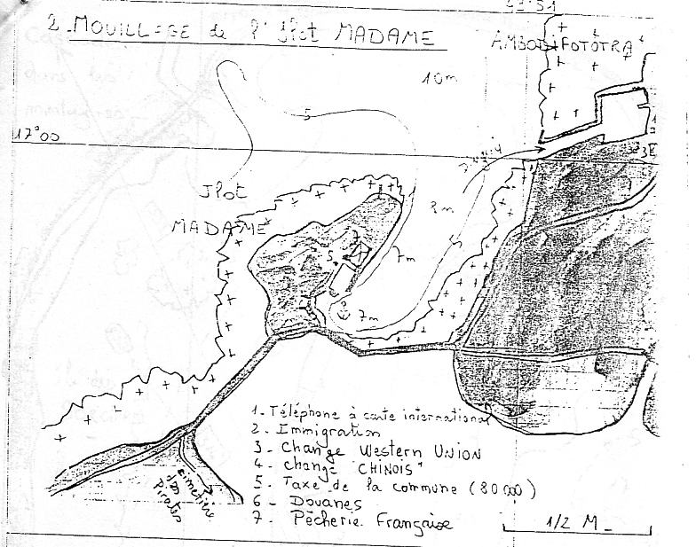
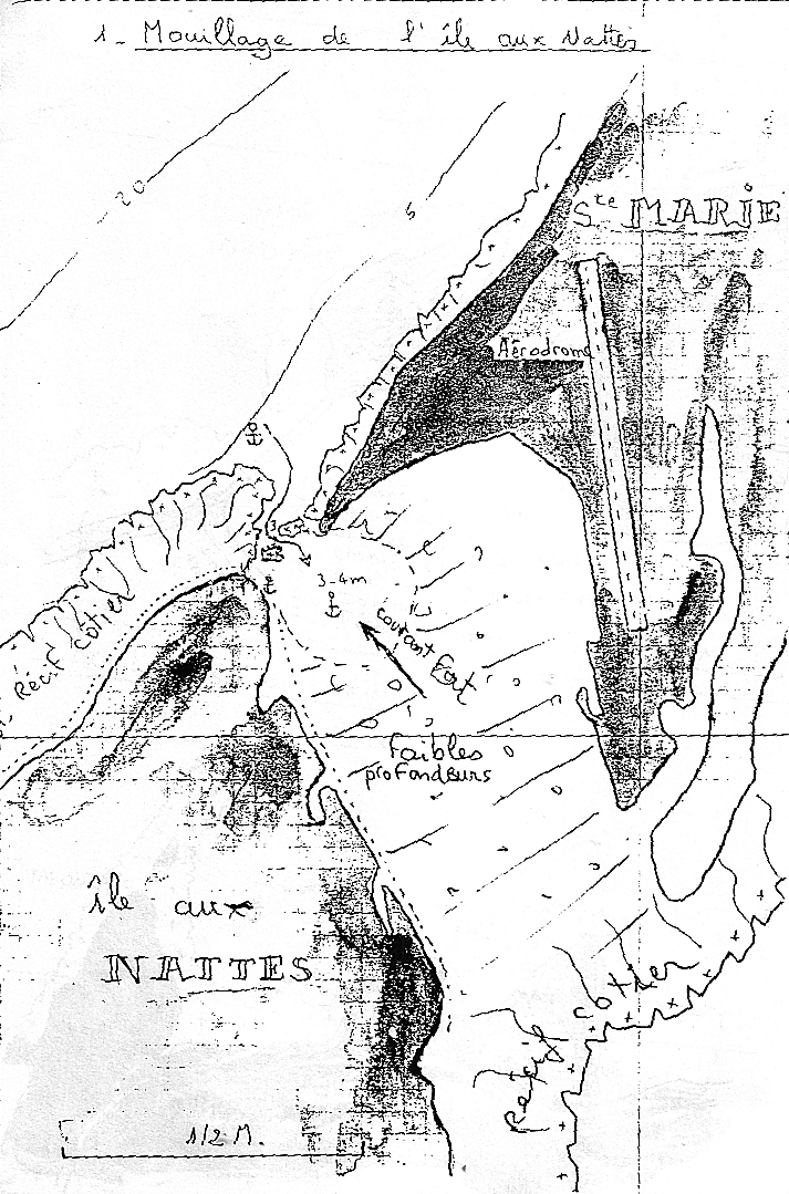
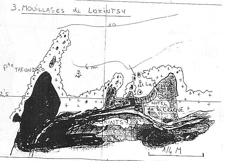
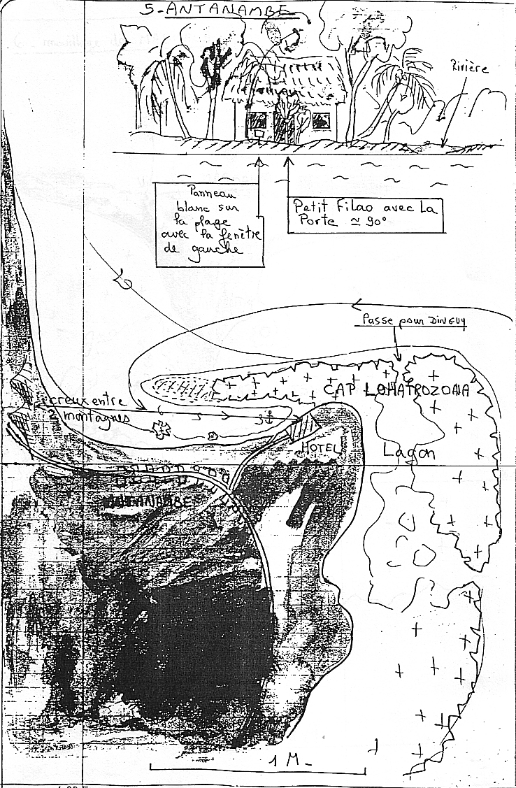
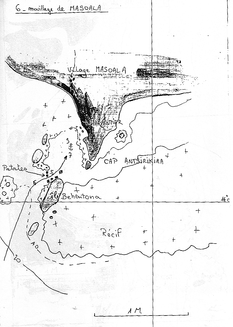
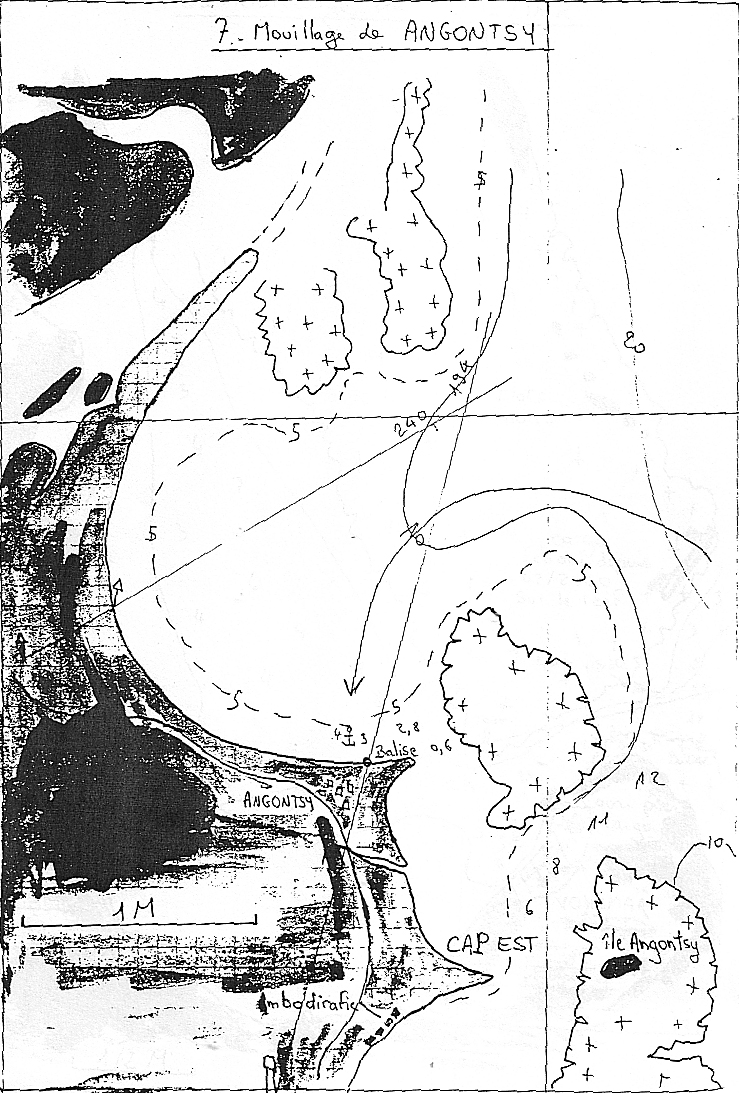
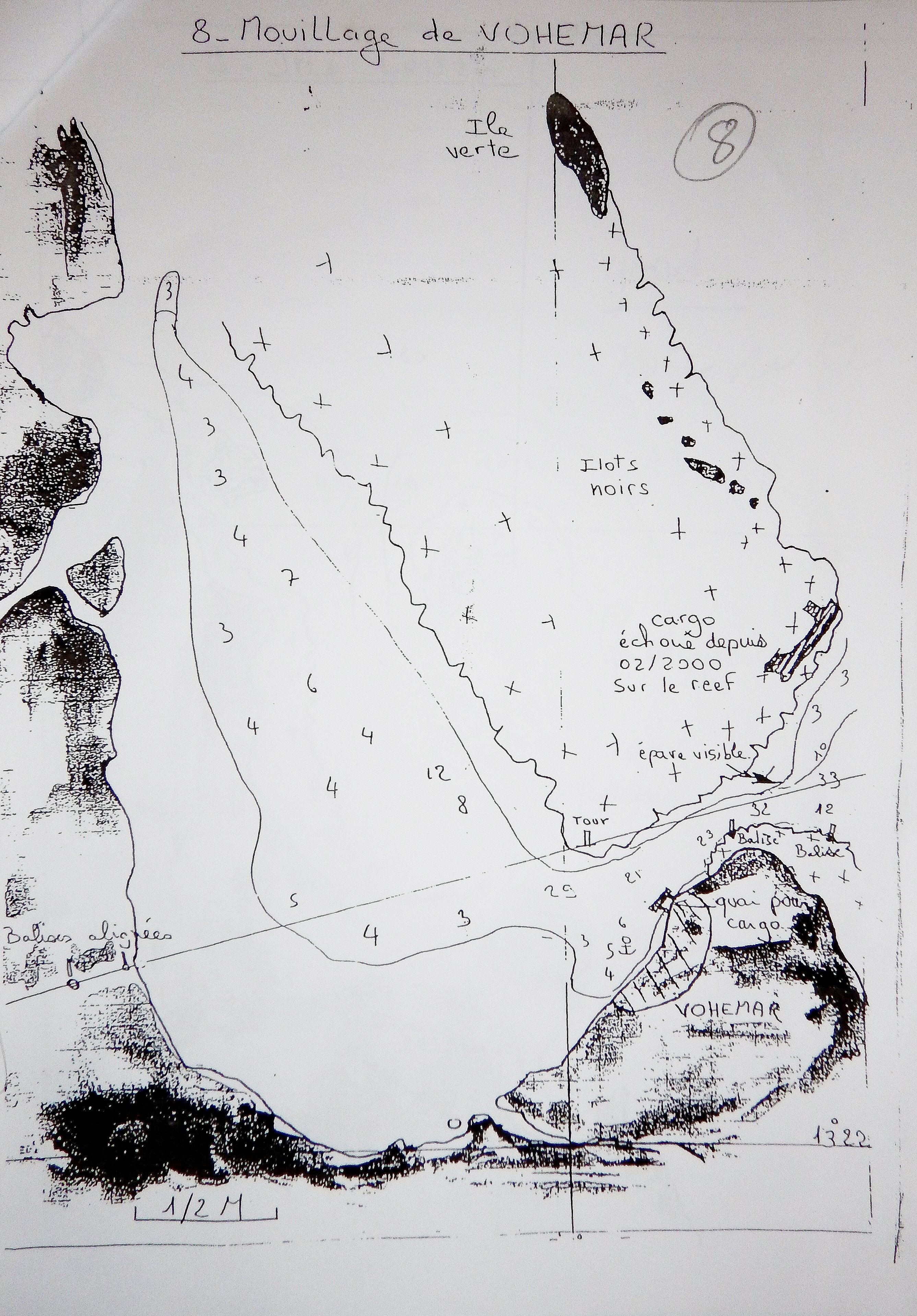
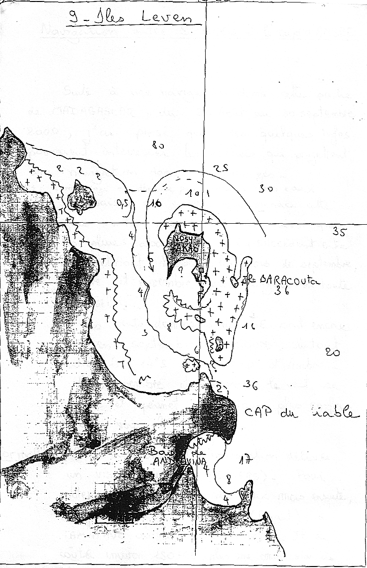
10. SOUTH AREA
10.1 Introduction
10.2 Barren Islands
Pulau Bawah (xx°xx.xxN xxx°xx.xxE) is the
Nosy Mavony
2015 Totem - (18°18.472S,43°44.942E), 65ft, Sand / Coral, South wind so anchoring on north side - not very good though. Poor holding with much flat coral. So so for flat, but lousy when wind against current.
Nosy Lava (Barren Islands)
2015 Totem - Fish camp,18°34.838S,43°55.922E,37,Sand / Coral, NE side of island - so much better protection than the last island. The island and surrounding reef isn't so different, but other near islands reef keep seas flat.
2015 Totem: South of Madagascar’s Cap St Andre is a sprinkling of islands, around 15 nautical miles off the coast. They’re aptly called the Barren Islands: some are no more than long spits of sand, just a couple of meters above sea level, and most have no more than thin sandy soil.
We spent a number of days anchored off Nosy Lava (the third Nosy Lava we’ve encountered in western Madagascar!), the site of several Vezo fishing camps. In places like this, it’s good practice to go ashore and seek an elder/leader to ask permission to anchor, showing up in their backyard as we do. Boats in our wake: ask for the président campement. He arranged for us to bring our donations to a covered meeting space. It started off more organized, but actually turned into kind of a grab-fest very much like the prior day.
I sat down today with the intention of sharing a lookback post on things that went well (and things that didn’t) for our transit to South Africa as a follow up to the passage report, but while culling photos and reflecting, I kept coming back to these striking islands and the people we met in our final Madagascar stop. Yes, people. Because although these small, flat islands grow little more than scrub and some grass- if they grow anything at all- for much of the year they are home to semi-nomadic families from Madagascar’s Vezo tribe.
Our visit was at the latter end of their seasonal migration; in November, when the risk of cyclones begins to increase, they depart for the mainland. But during the dry monsoon, they sail their pirogues to these outlying islands, build seasonal camps, and live from what they bring and what they glean while drying fish to transport to market.
The basis of Vezo culture is tied to the ocean: ply the water in dugout outrigger canoes, hand carved and carefully decorated. It’s hard not to compare them to the big metal trawlers we saw running lines just a hundred miles north, and wonder how the Vezo and their beautiful boats can compete with big commercial fishing operations. In fact, they can’t- their fishing grounds are threatened by industrial shrimp fishing and illegal fishing with SCUBA.
It turns out there’s another big risk to the Vezo besides the trawlers we saw. Mining can destroy the fragile ecosystem of islands, where turtles and seabirds nest. Runoff damages the surrounding coral reefs. There’s been mining here in recent decades, and islands are again targeted for extraction by a politically powerful, well-funded Malagasy group.
Vezo fisherman, through their community organization- the Vezo Miray Nosy Barren– recently wrote and signed a “lettre de doleance” to help inform authorities, and raise attention to this threat to their livelihoods and the environment. It is a big challenge for them to face down political power in a country with deep-seated corruption.
We spent a number of days anchored off Nosy Lava (the third Nosy Lava we’ve encountered in western Madagascar!), the site of several Vezo fishing camps. In places like this, it’s good practice to go ashore and seek an elder/leader to ask permission to anchor, showing up in their backyard as we do. But before we could get the dinghy into the water to make our way in, a pirogue approached. Would we like to trade for lobster? We invited the paddlers to sit in the shade of the cockpit and passed around glasses of water. Did we have anything to trade? Communication is rough, but passable, accomplished with a mix of sign language, our feeble French (theirs wasn’t much better), and a great phrase book with French, English, and Malagasy gifted by friends up in Nosy Be.
Trading for lobster sounded great: succulent tails drizzled in garlic butter and seared on Solstice’s barbecue later made a memorable dinner shared with friends. But although trading is a mutually beneficial and enjoyable aspect of our life, this time around, we weren’t actually all that interested in trading. As we learned more about the subsistence lifestyle led by the Vezo, and saw for ourselves how little they have, it seemed like the perfect place to give without seeking an exchange.
Living on a boat, we’re always chasing simplicity. In part, it’s an ideal for how we live. It’s also based in practicality, because we have very limited space: the walk-in closet of my past life is a far cry from the couple of shelves in a locker I share with Jamie now. But we have plenty, and we have access, and we will be able to buy new duds in South Africa. This was the perfect time and place to go beyond a few tee shirts for gifts. We tried to work out who the local leader was, but didn’t know what words to use – my English/French/Malagasy book has phrases for “what tribe are you from” and “does your tribe have a king” – not helpful, and didn’t to help us establish who the village leader was (and no, it turns out, the Vezo have no king!). Absent a leader, there was some chaos when we brought our first bag to shore for gifting.
We did finally figure it out on the second day. Boats in our wake: ask for the président campement. He arranged for us to bring our donations to a covered meeting space. It started off more organized, but actually turned into kind of a grab-fest very much like the prior day.
The third day, we realized each little camp on Lava has their own president. Eventually met three different encampment leaders there. And after that first visit, we went back through our closets and decided there were a whole lot of things we hadn’t felt worth giving away, and others that we had thought we’d hang onto for ourselves, that all ended up in another series of bags that went to shore.
Also appreciated was fresh water. There’s a well, but it’s not good drinking water. We ran our watermaker daily to fill jerry cans, ferrying ours to shore to decant to others and topping up any that were brought out to Totem.
To learn more about what’s happening in the Barrens, check out the site of an NGO called Blue Ventures. Among various projects, they’ve been working since 2010 to create Locally Managed Marine Area (LMMA) encompassing the Barrens; it would be the largest reserve of it’s kind in the western Indian Ocean.
Reef assessments shared by Blue Ventures show that the Barrens have SIGNIFICANTLY more fish biomass and coral cover than any other marine reserve in Madagascar. It holds five species of marine turtle, endangered seabirds, eight species of critically endangered sharks – 51 threatened species in all. Across Indian Ocean reef assesments, only Chagos exceeds the biodiversity and density of the Barrens. To those who know anything about Chagos, this speaks volumes. But these islands are very much at risk, and Blue Ventures is working hard to bring positive change. Blue Ventures’ mission extends beyond marine life. Their LMMA proposal would safeguard the livelihood of indigenous people and their fishery; the holistic plans in BV’s other projects here include health care, education, marine management, and more (Blue Ventures has a factsheet on the Barrens, is available at this link).
Other than the initial meeting and query about trading for lobster, we didn’t attempt any trade. But one afternoon, someone noticed that I liked the model outrigger canoes. And one after another, little outrigger models started showing up on Totem. A couple of them were even completed in our cockpit, colored in with the oil pastels we were giving them for kids!
The Barren Islands made for an unforgettable stop, with people who were fun and interesting and enjoyable to spend some time with. We spent hours every days with visitors on the boat trying to talk (with varying degrees of success). I wish we could have stayed longer, but we were watching for weather conditions to sail from Madagascar to South Africa – and when the weather said ‘go’, we went!
If we could do it again, we’d go with more time (yes, I say this often, but I really do mean it!). The reefs begged exploration. I’d have fulfilled my dream to go sailing in a pirogue. But hopefully, someday we’ll be back, and see how the Vezo are doing.
10.3 Port d’Ehoala/Ft Dauphin/Taolagnaro (S25.07 E46.96)
2011 Papillon - Papillon and Nauti Buoy Too arrived in Port d’Ehoala on Saturday afternoon, September 17, 2011 after battling 20 knot headwinds and 2-3 meter breaking seas for 5 hours. The new port, built by Rio Tinto Mining, has only been open for a couple of years. It offered safe berthing behind the breakwater and cement quay. Papillon rafted to Nauti Buoy Too to complete formalities. The harbormaster, Nicholas, was very helpful. He called an agent (MSC) who organized the officials who came to the quay. Because the facility was built for ships, the sailboats sat so low that we couldn’t get off and they couldn’t get on.
The authorities in Port d’Ehoala/Ft Dauphin aren’t used to cruising boats, and are going out of their way to make their annual budgets on us. The MSC agent initially asked US$100 each for himself, Customs, Immigration, Health, and Police. Nauti Buoy Too negotiated US$80/agency and paid it on arrival. Papillon stalled, saying we needed to get local money (Ariary, or MGA) from the ATM, and insisting on invoices in writing from each of the agencies. Immigration came back with $80 OR 100,000 MGA ($50.00). We challenged the agent, then told him we’d pay only MGA 100,000 per agency. A third boat, Moonbeam, came in and was given invoices for MGA 100,000/agency right off the bat. Nauti Buoy Too registered displeasure with the agency...but didn’t get any $$ back.
Meantime, the Port d’Ehoala manager met with the yacht captains re: port charges. We’re the first cruising boats they’ve had, and while they claim not to have invoiced us at commercial rates, they did present each boat with a 300 Euro bill (US$420). The captains protested loudly...especially since Mauritius and Reunion were between US$80-115/week, including power and water...where as we were anchored and had to generate our own p&w.; After much negotiation, they got down to around 120 Euros + 20% VAT, which is about $200.
The port fees plus agency and check-in came to US$450, making this stop our most expensive ever. Upon leaving, officials from Ft. Dauphin attempted to collect another US$400 per boat, but the yacht captains refused to pay.
Port d’Ehoala wants to attract cruisers, and has plans to install a floating dock inside the breakwater. They are reconsidering their fees and are working with the officials to come up with something more reasonable. However, cruisers are advised to contact the port and an agent and insist on a quote in writing before heading there. (The old Ft. Dauphin anchorage in the heart of the town is a security risk and not recommended.) Nicholas also asked that yachts contact the port by e-mail before leaving their last port. See www.ehoalaport.com for current contact information and charts of the port.
Although well protected from wind and wind waves, there was considerable surge within the quay. It was more comfortable to move outside to the anchorage, which both Nauti Buoy Too and Papillon did on September 18. The Port d’Ehoala anchorage is open to the NE. Even in easterly winds, the fetch can become extreme. During our stay we sat out 24 hours of 30-35 knot winds and 3’ fetch in 15’ of water, during which we broke one bridle at the devil’s claw and chafed through a ¾” nylon line on another. To top it off, the port was loading titanium ore on a ship. The ore is black before processing to the white pigment titanium dioxide. We were well dusted with black grit.
10.4 Toliara (S23.38 E43.66)
2011 Papillon - Papillon, Nauti Buoy Too, and Moonbeam arrived in Toliara on Friday afternoon, September 30, 2011 and couldn’t raise an official on the radio. The captains went into the dock to find the harbormaster, but no luck. They did meet Germain and Zose who offered services as a guide and driver for MGA 70,000/day no matter what we did. G&Z; took them to the harbormaster’s office in town & they completed the paperwork. The word was that we’d each need to pay something around MGA 70,000 upon check-out. He made it sound like he was the only one we’d need to see, but...
Saturday we went in to go to town and were met by Customs on the dock. Nauti Buoy Too had used his dingy to ferry all of us, as his crew was staying on the boat and could just come and get us when we were ready. That meant we didn’t need to leave a dingy on the dock. The Customs agent desperately wanted to come see the boats but had a meeting so we went by his office to have our crew lists stamped. He was angry that we hadn’t checked in with him on Saturday, but told the Captains that we could get duty free fuel for a payment of MGA 45,000 (per boat? collectively???). We had papers to bring back Monday morning to initiate the fueling process.
Monday the captains went in at 7:30 am to get the papers stamped and order the fuel. Germain & Zose drove and were coordinating the fuel purchase. Customs wiggled and waggled and OKed taking on fuel for the fee of MGA 30,000/boat, but there was no duty free discount. There was another office to visit to get another stamp, then the oil company. The oil company charged MGA 2600/liter, when the pump price was MGA 2580/liter. We understood that the price was delivered. The truck was supposed to be on the dock at 11:00 am, but didn’t come until 2:30 pm (dead low tide). We each, in turn, rafted to a tug and they delivered the fuel. Only Papillon was capable of measuring exactly how many liters were taken on, and we were 47 liters short out of 400 liters ordered. The oil company manager showed up hours later to get his money and was indignant that we said we’d been shorted 12% of the order. He was worried that we’d shorted the money, but we paid him the agreed amount. Then he wanted another MGA 100,000 for the truck. The captains wouldn’t pay, so the guide and driver offered to handle the problem because they had organized a fixed price deal for the fuel. (Note: This “scam” for the privilege of taking on duty free fuel in Madagascar is wide spread. In fact, the wholesalers have paid the duty, and if they back it out of the price for the cruisers they have to apply for a rebate from the government. The government is broke and won’t rebate the amount of the duty. Hence, no one will honor the duty free price anywhere in Madagascar, but there’s no way to know that before you pay Customs for a “duty free” permit.)
Between 10:00 pm Monday night and 1:00 am Tuesday morning Nauti Buoy Too’s dingy was stolen. He offered a US$1000 reward (MGA 2,000,000) to no avail. A boat captain told him that there’s a local mafia that makes it unsafe to be in town at night, or to look too hard for stolen goods.
We wouldn’t want to have missed Mauritius or Reunion, as they were both highlights of our trip around the world. Southern Madagascar however, was not comfortable in any sense of the word. Due to the alternating high and low pressure systems moving east from South Africa, making the jump between Reunion and SA in one jump can involve some rough weather, so it’s a hard choice to not stop to wait for safe weather windows. Tucking in along the shore, but not visiting major towns, or going the more traditional route around the top of Madagascar are both certainly worth considering.